ChattaVOL
Member
We got the northern shift at 12z on the EURO a couple of days ago... I think you are seeing it come the other way now and it will trend this way now
Someone post that MSLP trend right before the Atlantic transfer. That will tell the whole storyThat is a huge shift south in the axis!
More southern B transfer maybe?

Exactly what I was thinking....is the MSLP trend is anything like I am thinking, the shifts aren't done.Someone post that MSLP trend right before the Atlantic transfer. That will tell the whole story
Someone post that MSLP trend right before the Atlantic transfer. That will tell the whole story

It’s struggling in the long range with the CAD still. This will continue to come southUmm -- weird. By 4pm Euro suggests ATL already up to 44º with a severe storm threat. That's a heck of a CAD erosion... has surface temps already up to 37º by 1pm.
View attachment 187617

It seems a lot of offices and pros di** ride the euro til the wheels fall off. Now they are forced to play catch up.WSW just extend south of i-20
I just received the alert and I'm 8 miles from the Hartsfield-Jackson.Euro with a huge cave. ATL fully in the cross hairs. WSW should be moved south soon
yep. Sharpening more than anything
If it continues we will get more sleet and ice, not a great trendThere's your trend! Keeps getting pushed slower and more to the south, leaving the CAD in place longer. Hopefully that continues.
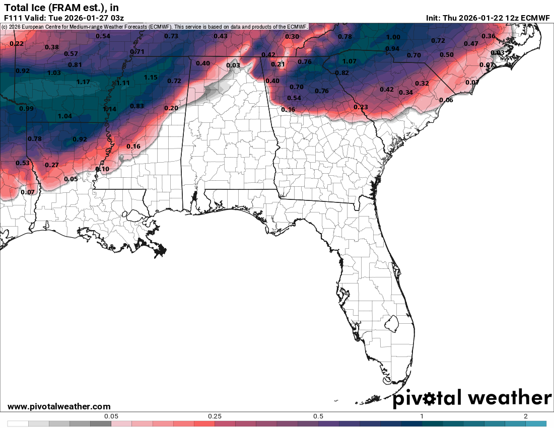
If it continues we will get more sleet and ice, not a great trend
You would think that would tip the scale to put WSW up for Atlanta and Columbia SC
Sent from my iPhone using Tapatalk
Except for BHM!
Atlanta is nowYou would think that would tip the scale to put WSW up for Atlanta and Columbia SC
Sent from my iPhone using Tapatalk
Surely they missed the 12z models lol. What a failCAE in their discussion DECREASED confidence in freezing rain. Man do what??
Its exactly what they were waiting for.Guess the Euro was enough for them to see haha huge expansion
View attachment 187619
I don't think many people have a proper appreciation for the magnitude of what's coming.
I have a theory that some mets live on a 12 hour lag when it comes to forecasting. Like I understand you don't need to shift your entire forecast off one set of models, but you have to keep up with trends. The warmer trend was Tuesday into yesterday. It doesn't take a freakin rocket scientist to see that it stopped & started trending colder since last night.Surely they missed the 12z models lol. What a fail
Gandy never wavered. Prob bc he’s retired now and answers to no one.I have a theory that some mets live on a 12 hour lag when it comes to forecasting. Like I understand you don't need to shift your entire forecast off one set of models, but you have to keep up with trends. The warmer trend was Tuesday into yesterday. It doesn't take a freakin rocket scientist to see that it stopped & started trending colder since last night.
Could be wrong but I want to say 2014Does anybody know - or know where I can look to find - the last time FFC issued an Ice Storm Warning? However long it’s been, that streak likely ends tomorrow.
—30—
Drier might not necessarily be a bad thing if we trend cooler.Still of note, the AIFS continues to tick drier in the face of the rest of the modeling. Going to be interesting to see who wins that one
Surely they missed the 12z models lol. What a fail

As @Webberweather53 mentioned somewhere lighter precip will only help CAD stay locked in as well as accrue freezing rain more efficiently. Hopefully it trends dry enough that icing impacts are reduced but I still think most of the CAD zones are going to see steady freezing drizzle at most times for this event.Drier might not necessarily be a bad thing if we trend cooler.
If it continues we will get more sleet and ice, not a great trend


