May be banter but they need to get rid of those snow accumulation forecasts on a weather app. It's going to catch so many people with their pants down and it's honestly frustrating. Those apps are intended for everyday, is it going to be 40 or 70 type of deals, not extreme phenomena like what we're dealing with.
-
Hello, please take a minute to check out our awesome content, contributed by the wonderful members of our community. We hope you'll add your own thoughts and opinions by making a free account!
You are using an out of date browser. It may not display this or other websites correctly.
You should upgrade or use an alternative browser.
You should upgrade or use an alternative browser.
Wintry January 23rd-27th 2026
- Thread starter SD
- Start date
iGRXY
Member
Every FRAM model run is pushing an inch of accrual. I don’t see how we aren’t getting at least 0.75” minimumGood lord this is FRAM? Good lord
That model is almost on its own now. Pretty much all others have settled into the 1-2" range (ignoring NAM)
This model is losing me now. I had more faith in it but now it's limiting QPF too much. We will have moisture from the gulf and the other models are holding steady at 1" + of QPF. Doesn't make sense to keep supporting it
For Raleigh....Its all 3 major AI models...GFS-AI...AIFS...Google AI around 0.5-0.7" QPF while the major globals (UK/GFS/Euro/CMC) are all double that. Let's see who wins...
Again...this is just the overrunning part through Sunday night...not counting what comes after the transfer. This part would be mostly sleet I hope.
All I have heard is how great the AI models have been...

AI Models

Yes, which unless this thing stuns everyone and dumps 10 inches of snow in the Piedmont, it’s not happeningAnd that’s probably gong to be accurate, but isn’t the GFS showing below zero temps?
I'm looking at nowcasting and short term models for QPF at this point. But I tend to trust the euro and gfs over ai...For Raleigh....Its all 3 major AI models...GFS-AI...AIFS...Google AI around 0.5-0.7" QPF while the major globals (UK/GFS/Euro/CMC) are all double that. Let's see who wins...
Again...this is just the overrunning part through Sunday night...not counting what comes after the transfer. This part would be mostly sleet I hope.
All I have heard is how great the AI models have been...
View attachment 187657
AI Models
View attachment 187658
BlueRidgeFolklore
Member
Sounds like WNC during Helene. If I learned a few things from that time that will buy you a few days, it's this:This is a really sobering thought. Imagine communications will grind to a halt if cell towers lose power and generators run out of fuel. Bad situation…
- Keep a battery powered radio on hand. A lot of good information gets put out on the radio when all other lines of comms are down.
- Keep some cash on hand. Cards didn't work when communications went down.
- Fill up your cars and if you have an extra gas can, keep one filled up. I ran out of gas trying to find gas.
- Go grab some dry foods for easy storage and easy cooking. Not bread and milk.
dsaur
Member
It's because ya'll got trashed in that last ice storm. Only have to live thru that once to realize what might happen. Hope you fair a lot better this time!!I imagine part of that is post-Helene fears. At least here in Augusta nobody really expected it to be nearly as bad as it turned out to be, so people are being very cautious now. At least that is what I am seeing in my area based on how busy the grocery store has been.
NAM following AI models for QPF...so far but we asking for a lot with the 84 hour NAM. But point taken and agree...let's see how the mesos look tomorrow. I just thought it was interesting the AI models are clustered and the non-Ai are clustered.I'm looking at nowcasting and short term models for QPF at this point. But I tend to trust the euro and gfs over ai...
I think the EPS is hard to beat with QPF but see what it shows tomorrow 12z.

rburrel2
Member
Comes down to how much convection blocks moisture transport to the Midwest. The fact that the euro is showing that now tells me it’s probably happening to some degree.For Raleigh....Its all 3 major AI models...GFS-AI...AIFS...Google AI around 0.5-0.7" QPF while the major globals (UK/GFS/Euro/CMC) are all double that. Let's see who wins...
Again...this is just the overrunning part through Sunday night...not counting what comes after the transfer. This part would be mostly sleet I hope.
All I have heard is how great the AI models have been...
View attachment 187657
AI Models
View attachment 187658
rburrel2
Member
Also you know if you lived in Kentucky the drier models would verify there… and they probably will. It makes some sense that the best qpf runs more along the arctic frontal boundary.
This isn’t your granddaddy’s ice storm. Lows of 22 and 24 on the southern fringes of the wedge during the peak. This winter storm will most likely be the new standard
Models seem to be trending towards what Windborne’s proprietary model had a few days ago
Blue_Ridge_Escarpment
Member
Models seem to be trending towards what Windborne’s proprietary model had a few days ago
In regards to temps I’d say so, precip but south of there per the latest 12Z guidance.
Tsappfrog20
Member
Good look at the GRAF from our friend Gerald!!
Sent from my iPhone using Tapatalk
Sent from my iPhone using Tapatalk
Tsappfrog20
Member
Here is WRAL forecast right now!
Sent from my iPhone using Tapatalk
Sent from my iPhone using Tapatalk
Dunkman
Member
Here is WRAL forecast right now!
Sent from my iPhone using Tapatalk
Southern Wake getting screwed with all ZR, seems about right.
WxBlue
Meteorologist


That is an insane forecast from WRAL. They're usually cautious and conservative too.
WEATHERBOYROY
Member
HRR 18 VS NAM 3K 12Z snow line south for the hrr. Lp off cal coast slower on the hrr. overall flatter approach on hrr.
I’d recommend some alternate heat sources!! If you have a fireplace, stick up on wood!!
In 2002 I was without power for 5 days and lived on one of the busiest roads in Greenville! Even with fireplace going, it was in the low 50s in the house! Just a friendly reminder!
In 2002 I was without power for 5 days and lived on one of the busiest roads in Greenville! Even with fireplace going, it was in the low 50s in the house! Just a friendly reminder!
beanskip
Member
"Tips for surviving an ice storm" sounds like a good, seperate thread topic with stuff about generator safety, etc.I’d recommend some alternate heat sources!! If you have a fireplace, stick up on wood!!
In 2002 I was without power for 5 days and lived on one of the busiest roads in Greenville! Even with fireplace going, it was in the low 50s in the house! Just a friendly reminder!
beanskip
Member
Both 18z NAM and HRRR coming in a bit warmer ahead of the storm. Of course, lately good early developments have just gone to hell later in the run, so maybe this is a good sign!
Here is WRAL forecast right now!
Sent from my iPhone using Tapatalk
I'm right on that boundary in Wake County between 0.5-1.0 and around 0.5 inches, not that it is going to matter too much.
WxBlue
Meteorologist
Just because you can prepared the best you can do doesn't mean this won't suck badly for several days. Especially if the power goes out with the cold that is following.Lots of fear mongering going on. Just be prepared the best you can. That's all anyone can do spread the crazy fear that's flying around just makes things worse
NBAcentel
Member
Yessir. First call maps right here. First is ZR, second is sleet. Not enough confidence in snow in our area to make a map, but I’ll probably do one later. I’m on the slightly southern end of forecasts by a smidge, but reason why is because areas just south of GSP/CLT have a longer duration of ZR (first areas to transition) and likely lighter rates time to time for more efficient accumulation, vs areas further north where sleet and heavier rates may cut into accretion a bit. Still looks like a significant, damaging ice storm for CLT/GSP. Could be the worse one since Dec 2002. Only hope here is trending some more colder low levels via lowering heights over the next day to our NE, any confluence helps in driving more of a stronger cold nose@NBAcentel are you putting out a call map?


LukeBarrette
im north of 90% of people on here so yeah
Meteorology Student
Member
2024 Supporter
2017-2023 Supporter

Someone messed up at NWS Blacksburg, snow map doesn't quite line up with physical map LOL
foothillscrewzone
Member
It's building in still. Posted too soon. 18Z precip shield is slightly south from 12ZAnd NAM says what CAD in GA?
.png")
packfan98
Moderator
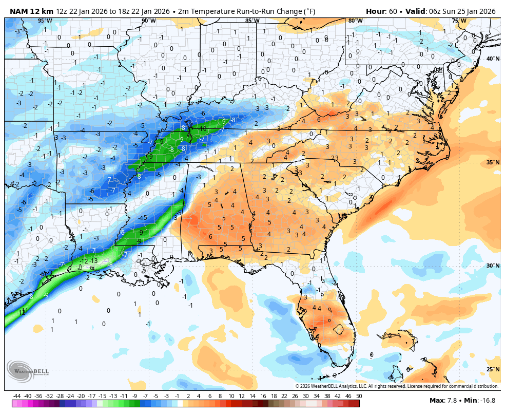
Surprised to see the 12k NAM come in warmer with the cad.
Brandon10
Member
What is the NAM doing? 
beanskip
Member
Looks like the Baja energy moves east more quickly on this run. CAD either delayed or weaker. Thought for sure after the Euro we were entering a relentlessly strengthening CAD mode.
Seems like GSP lowered ice totals in their latest winter storm watch
Does anybody know - or know where I can look to find - the last time FFC issued an Ice Storm Warning? However long it’s been, that streak likely ends tomorrow.
—30—
Could be wrong but I want to say 2014
The last widespread moderate to major icestorms in N ATL were in 12/2005 (moderate) and 1/2005 (major). For S and ATL metro as mentioned it was 2/2014.
foothillscrewzone
Member
.png")
Blue_Ridge_Escarpment
Member
NAM finally wakes up with the precip this run
foothillscrewzone
Member
Hi-res NAM probably has a better read on temperatures .png")
foothillscrewzone
Member
Takes sleet down into NEGA.png")
Massive changes on the 18z NAM, it's shellacking central NC with a sleetstorm after the dry slot on the 12z run.
I’m quite concerned for an elderly relative in Fayetteville, NC who requires a plug in oxygenator. I’m keeping her updated on the wx.
Any educated guesses as to whether or not that area will likely have widespread power outages? Any responses would be greatly appreciated.
@Webberweather53 since that’s your hometown and you’ve got a great knowledge of their history
Any educated guesses as to whether or not that area will likely have widespread power outages? Any responses would be greatly appreciated.
@Webberweather53 since that’s your hometown and you’ve got a great knowledge of their history
beanskip
Member
Funky run -- colder in the Arklatex, but warmer in CAD region. Seems like a ton of precip still has to move through from way back in Texas and it's already Sunday morning.