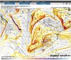
Northern SC/ Piedmont NC gets pounded this run.
I do not like this look being in the piedmont at this time. I'd much rather take a suppressed look this far out.
Northern SC/ Piedmont NC gets pounded this run.
I think more of SC/GA will be in the game. I think we will see south shifts due to blocking.


Cash me out! ENC gets robbed lol
Northern SC/ Piedmont NC gets pounded this run.

This will be fun to moderate. We need competing factors here to get this to work for our backyards

Always . I’m not ready to get nasty yet so good luck to all
Except Brick
Sent from my iPhone using Tapatalk

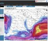
im starting to wonder if its going to trend northwest. looks like its trending southward each runAlmost perfect spot for this low once you get your 100-150 miles NW trend.View attachment 63102
im starting to wonder if its going to trend northwest. looks like its trending southward each run


Me too. I think this system has massive potential for many of us on here. Plus, I think the 1st will help this one, and look how much it is trending colder for that one.I’ll take that look 6/7 days out
Sent from my iPhone using Tapatalk


We are going to fight 2m and 925’s it appears. All other levels look fine for the most part. I still think this has massive potential (and not just talking about the mnts or WNC).
This has more potential then anything we’ve seen the last 2 years ??I think that if we can trend the high in a good spot and it holds, maybe we see a response in 2m temps and 925mb temps as well. Also, if we can bundle that energy a bit better, that could bring a nice storm that will help some as well. I think all in all....a GREAT look this far out right now.

I cant remember the last time i tracked back toback systems lol my wifes going to kill me........This has more potential then anything we’ve seen the last 2 years ??

Agreed!This has more potential then anything we’ve seen the last 2 years ??
We really need that piece over Iowa to rotate through the lakes first.Not gonna lie, this both excites and scares me. The Euro is adding more energy from different areas each run.
That's not saying much.This has more potential then anything we’ve seen the last 2 years ??
Oh ok, lolThat's not saying much.

Agree. It also has the potential to be another snow-jam kind of nightmare for BMX, ATL and/or CLT. If that precip expands late in the game during a workday it will be a total cluster.I’d say this pattern has the potential to drop a significant storm(s) to the likes of which we have not seen for a decade or so.