-
Hello, please take a minute to check out our awesome content, contributed by the wonderful members of our community. We hope you'll add your own thoughts and opinions by making a free account!
You are using an out of date browser. It may not display this or other websites correctly.
You should upgrade or use an alternative browser.
You should upgrade or use an alternative browser.
Severe Jan 8-11 2024 System Severe
- Thread starter SD
- Start date
Don't you have pea gravel being dumped on YOUR Roof? @Shaggy? I've not seen this much heavy rain since Florence!NOt as windy as I would have thought
Stormsfury
Member
Glad you mentioned it.Very weird how we get these intense 10 min periods of stronger winds then it backs way off for a bit then another round of big winds, almost gravity wavish...
Weaker lapse rates at the low levels I believe contributed to the wave ducting and the "bursting" of higher and lower periods of winds.
Stormsfury
Member
Charleston area wind reports.
And as the last batch of rain pulls thru, a rogue lightning strike rumbles the silence.

And as the last batch of rain pulls thru, a rogue lightning strike rumbles the silence.
- Joined
- Jan 2, 2017
- Messages
- 1,566
- Reaction score
- 4,279
Over 5.5" of rain...flooding all over...zero wind yet thankfully
Downeastnc
Member
Decent couplet over Vanceboro right now here in the east....its part of the same cell that hit Surf City earlier I think.
Power flickered half dozen times, holding on for now amidst strongest winds of the day. I failed, got chairs all over the yard, grill blown over and limbs down. Continued flickers
Shaggy
Member
We.just got rocked. Biggest winds I've seen in years. I'm a few miles southwest of the airport along the river.Power flickered half dozen times, holding on for now amidst strongest winds of the day. I failed, got chairs all over the yard, grill blown over and limbs down. Continued flickers
Attachments
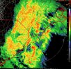
Gravity wave? 
Shaggy
Member
Wake low maybe?Gravity wave? View attachment 141023
NoSnowATL
Member
TidalGravity wave? View attachment 141023
78 mph wind gust reported at New River https://www.weather.gov/wrh/timeseries?site=KNCA&hours=72
Shaggy
Member

Ended up 4.1 for the event house got pressure washed
Really good thing we've lost the convection and no mechanism to transport this down, holy smokes... 3k feet up

Tornado warning for Carteret County.
Didn't see or hear anything but we had a radar indicated T warning a bit ago.....
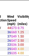
Lost power for about 1 minute, 70 sounds about right I heard some very unhappy noises from the structure of my dwelling around that time.@Disco_Lemonade @SENC yall got power?
Not just one gust to 70 but 3 over 20 minutesView attachment 141024
Darklordsuperstorm
Member
Winds are still whipping tonight. Enough to make my house hum.
but wait there’s more. Actually a lot of wind with this little thing..wow
These little straggler lines mean business. This is about the windiest it has been all day..pretty sure I just heard some of my drip guards get blown off the roof 
One last gust to 44 this morning with the showers that moved through. On my way into work this morning still saw some areas without power and a number of trees down in some yards here and there. Lots of broken pine limbs strewn about and oh the ground is like mush. Honestly amazed more trees didn't topple, no leaves probably really saved our buts
Downeastnc
Member
Yeah if this was April there would have been a lot more trees down...One last gust to 44 this morning with the showers that moved through. On my way into work this morning still saw some areas without power and a number of trees down in some yards here and there. Lots of broken pine limbs strewn about and oh the ground is like mush. Honestly amazed more trees didn't topple, no leaves probably really saved our buts
BHS1975
Member
One last gust to 44 this morning with the showers that moved through. On my way into work this morning still saw some areas without power and a number of trees down in some yards here and there. Lots of broken pine limbs strewn about and oh the ground is like mush. Honestly amazed more trees didn't topple, no leaves probably really saved our buts
Pines don't uproot they shed limbs and crowns.
Sent from my iPhone using Tapatalk
- Joined
- Jan 23, 2021
- Messages
- 4,590
- Reaction score
- 15,179
- Location
- Lebanon Township, Durham County NC
Confirmed EF1 in Claremont