-
Hello, please take a minute to check out our awesome content, contributed by the wonderful members of our community. We hope you'll add your own thoughts and opinions by making a free account!
You are using an out of date browser. It may not display this or other websites correctly.
You should upgrade or use an alternative browser.
You should upgrade or use an alternative browser.
Wintry Jan 23-27 Winter Storm Obs
- Thread starter Rain Cold
- Start date
Ryan87NC
Member
Torrential downpour of sleet in Lewisville! The little things hurt when they hit your face!
Heavy sleet in Matthews
Forevertothee
Member
Back to all sleet. We may actually get to levels that Greenville achieved. Moderate. Temp up to 28.
Update 5pm: All ZR and fast development of icicles.
Update 5pm: All ZR and fast development of icicles.
Last edited:
MichaelJ
Member
Moderate to heavy sleet, 20/18 in W-S
Looks like we're already up to 29-30, but that seems to be where a lot of the western upstate settled. let's see
33-34 degrees across Anderson- Oconee counties.
broken025
Member
Sweet fest in Waxhaw
power lines picking up a notable white sheen now from a distance, just watched the first branch fall in the backyard
GoDuke
Member
The big line is here. It’s all heavy sleet so far at 22 degrees.
lcpdk
Member
22 degrees and starting to sleet in eastern Forsyth County NC
kennedybb6
Member
It sure isSweet fest in Waxhaw
SWVAwxfan
Member
starting to get really concerned about the Columbia SC metro. still 28 degrees with that line just to the west.
WxBlue
Meteorologist
NBAcentel
Member
the back edge is just above here. This afternoon was all zr and no sleet! Fortunately power is still on - it’s hard to measure ice when it’s still falling lol. It looks to be about .4” or so. After seeing some of the damage in Mississippi from their inch of ice I am glad we missed all that damage.
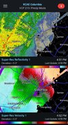
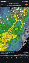
R u kidding me? A QLCS with SLEET?! Add that to the list of things I've never seen before. This system has defied all physicsHeavy, heavy sleet. The line is intensifying into a QLCS. Can see some elevated supercells in the line in SC View attachment 189195
Sent from my SM-S156V using Tapatalk
wow
Member
The band is coming in.. heavy sleet. Just heard a bit of thunder!
StormSurf
Member
16/14
Heavier sleet now. Still has Not gone to ZR.
NWS had Roanoke as ZR for the day but has revised to a mix.
Heavier sleet now. Still has Not gone to ZR.
NWS had Roanoke as ZR for the day but has revised to a mix.
chuckhendo
Member
I posted that in the other thread - pretty cool. Didn’t know that was a thingView attachment 189194
Bores over CAE.
Rain/sleet just started here. Pretty heavy right now
If this was snow I’d say it was ripping fatties but this is skeet so I’ll just say it’s heavy af
GeorgiaGirl
Member
Well, apparently, I actually am not above freezing or am not above freezing enough, because I just took a look and there are some tiny icicles on the rooftop.
I am not in the mood to go look further outside, but if I am continuing to struggle like crazy to get above freezing...woof to my northeast.
I am not in the mood to go look further outside, but if I am continuing to struggle like crazy to get above freezing...woof to my northeast.
Mpirone12
Member
NWS says .10 to .20 FR for triad. I’m not sure how that’s all the moisture we get with these bands coming through until 10pm
Sent from my iPhone using Tapatalk
Sent from my iPhone using Tapatalk
iGRXY
Member
28/26 still ZR. Will do an official measurement at 5:30
- Joined
- Jan 23, 2021
- Messages
- 4,602
- Reaction score
- 15,197
- Location
- Lebanon Township, Durham County NC
Can’t remember what office said it but they said we were stretching the bounds of what was atmospherically possible.R u kidding me? A QLCS with SLEET?! Add that to the list of things I've never seen before. This system has defied all physics
Sent from my SM-S156V using Tapatalk
SWVAwxfan
Member
back edge is approaching me outside of Chrristiansburg. it was moderate to heavy sleet. Zero freezing rain here. thank goodness.16/14
Heavier sleet now. Still has Not gone to ZR.
NWS had Roanoke as ZR for the day but has revised to a mix.
Sctvman
Member
Guys this storm is as juiced as Barry Bonds. Could easily see another .15-.25” ZR in the triangle which will cause some real problems. Crazy to think essentially the entire eastern half of the country will be locked in their homes for the next 48 hours
iwantsouthernsnow123
Member
Unfortunately that's just not the case. High winds are expected through tonight, and with how much FZR we recieved today. This will cause even more problems and likely widespread power outages all across the area.Temp has risen from 26 to 31 since the 2nd wave started. Looked like CAD is breaking down. Think we dodged a bullet here with no power issues. Good luck to my SC peeps
Sent from my iPhone using Tapatalk
Freezing rain mixing in with the sleet in NW Winston Salem. Seeing rain streaks on the deck door.
Sent from my motorola edge plus 5G UW (2022) using Tapatalk
Sent from my motorola edge plus 5G UW (2022) using Tapatalk
iwantsouthernsnow123
Member
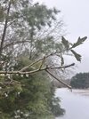
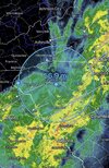
Me too... Finally crossing out of it. All too much too late, got around .65 to .75 of FZR across different areas. Worried about the winds tonight.I can see the daylight View attachment 189199
JimBobs
Member
The heavy storm line seems to be raising the temps a couple of degrees, whenever it arrives.
imagine we'll still have a little bit of mist or drizzle linger for a bit tonight but the heaviest ZR is done. it did pick up quickly but not a ton on branches, maybe a tenth down here
last time I saw sleet this heavy was 40yrs ago living in Rockwell NC. This is amazing!
Winds have picked up and frz rain picking up as wellstarting to get really concerned about the Columbia SC metro. still 28 degrees with that line just to the west.
BlueRidgeFolklore
Member
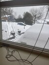
Just out of curiosity, which part of MD are you in?My god ive never seen this much sleet on top of snow. Gonna be a tough shovel tomorrowView attachment 189190

