• Hello, please take a minute to check out our awesome content, contributed by the wonderful members of our community. We hope you'll add your own thoughts and opinions by making a free account!

Jan. 17-18, 2026 SE Winter Weather Threat

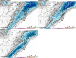
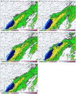
Best looking SREF I’ve seen. By the way, I HATE the SREF. However, it has behaved like several other models today in that as the runs have progressed, models that were not showing snow earlier, is now outputting more snow. I’m not sure if it’s due to dynamic cooling with increased precip or just a cooler column overall. Encouraging at least.
IMG_7907.png
 
Best looking SREF I’ve seen. By the way, I HATE the SREF. However, it has behaved like several other models today in that as the runs have progressed, models that were not showing snow earlier, is now outputting more snow. I’m not sure if it’s due to dynamic cooling with increased precip or just a cooler column overall. Encouraging at least.
View attachment 184784

Doesn’t this mean more than likely NAM will beef up too? Are they not related. Interested to See NAM thermals for GSP - CLT - GSO I really think someone Along - NW of that line(I-85) may see a surprise 1-2” if it’s gonna happen anywhere Tomm that’s my Call. (Yes I’m a Homer but I actually believe that)


Sent from my iPhone using Tapatalk
 
Best looking SREF I’ve seen. By the way, I HATE the SREF. However, it has behaved like several other models today in that as the runs have progressed, models that were not showing snow earlier, is now outputting more snow. I’m not sure if it’s due to dynamic cooling with increased precip or just a cooler column overall. Encouraging at least.
View attachment 184784
Ticked up and actually ticked SE, NAMs gonna be lit here in a few
1768696110699.gif
 
Birmingham had light rain at 6PM CST:

BIRMINGHAM LGT RAIN 45 32 60 W7 30.19R TC 7
6HR MIN TEMP: 45; 6HR MAX TEMP: 53; 6HR PCP: TRACE;

This was their forecast that had no mention of rain:

JEFFERSON-
INCLUDING THE CITIES OF BIRMINGHAM AND HOOVER
507 PM CST SAT JAN 17 2026

TONIGHT
MOSTLY CLOUDY. MUCH COOLER WITH LOWS IN THE MID 20S.
NORTHWEST WINDS 5 TO 10 MPH.
 
Doesn’t this mean more than likely NAM will beef up too? Are they not related. Interested to See NAM thermals for GSP - CLT - GSO I really think someone Along - NW of that line(I-85) may see a surprise 1-2” if it’s gonna happen anywhere Tomm that’s my Call. (Yes I’m a Homer but I actually believe that)


Sent from my iPhone using Tapatalk
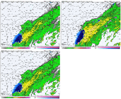
NAM was already beefed up precip wise. I’m curious on the westward extension of that heavy precip into the more favorable areas to get snow. Also, it would be great if the column is colder. Last shot to dial everything in before go time.
 
I just don’t see how we overcome the thermals, I don’t see the cold spilling over the mountains in time. We’ve had this scenario before and it does not work out for my area pretty much most of the times. I understand some models have upticked but I don’t think the cold will be here in time.
 
Birmingham had light rain at 6PM CST:

BIRMINGHAM LGT RAIN 45 32 60 W7 30.19R TC 7
6HR MIN TEMP: 45; 6HR MAX TEMP: 53; 6HR PCP: TRACE;

This was their forecast that had no mention of rain:

JEFFERSON-
INCLUDING THE CITIES OF BIRMINGHAM AND HOOVER
507 PM CST SAT JAN 17 2026

TONIGHT
MOSTLY CLOUDY. MUCH COOLER WITH LOWS IN THE MID 20S.
NORTHWEST WINDS 5 TO 10 MPH.

Can confirm this as I live in Hoover.
 
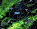
Pretty cool that you can actually see mesolows developing over the upstate of SC on some of the CAMs tomorrow as the low-level flow interacts with the mountains, generating some lee side eddies.

I highlighted a pair of these on the HRRR forecast

View attachment 184771


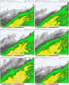
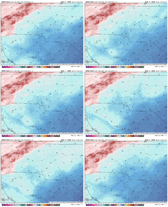
This actually helps back-build the precip westward in spite of the downsloping and allows the cold advection catch up more with the precip, increasing the chances for snow around GSP up to CLT

View attachment 184767

View attachment 184768
Think this can help down here in toccoa?
 
Updated forecast map for this event.

Only real significant change I've made since yesterday is the introduction of rain/snow mix chances down over Charlotte (& of course into the upstate of SC) due to the potential presence of a mesolow there.

View attachment 184777

Sneaky tough forecast with a lot of things going against snow here. But if snow does occur, it’s probably going to be absolutely ripping because of how warm the boundary layer is and the rates needed to overcome that
 
Sneaky tough forecast with a lot of things going against snow here. But if snow does occur, it’s probably going to be absolutely ripping because of how warm the boundary layer is and the rates needed to overcome that
Always enjoy your insights even if it is pumping the brakes. Hopefully some of us on the forum can catch a few positive surprised
 
Updated forecast map for this event.

Only real significant change I've made since yesterday is the introduction of rain/snow mix chances down over Charlotte (& of course into the

Sneaky tough forecast with a lot of things going against snow here. But if snow does occur, it’s probably going to be absolutely ripping because of how warm the boundary layer is and the rates needed to overcome that
I think this thing is going to over preform once that air column cools. You saying cold rain from wake county east is very bold of you. If it checks out I’ll give you brownie points.
 
Back
Top