Yep, almost same here: 6:40AM-2:15PM. Really glad it's back. Very thankful to have all our trees, and only minor damage to the wood shed. So bummed that the batteries on my weather station decided to go out yesterday I guess and it was too wet to get on the roof. Irma's gusts made me put it up there, and now I missed out on Zeta. But, since we lost power, I wouldn't have gotten good data anyway, I guess.6:15 am to 2:38 PM we had no power. At least it's on now finally.
-
Hello, please take a minute to check out our awesome content, contributed by the wonderful members of our community. We hope you'll add your own thoughts and opinions by making a free account!
You are using an out of date browser. It may not display this or other websites correctly.
You should upgrade or use an alternative browser.
You should upgrade or use an alternative browser.
Tropical Hurricane Zeta
- Thread starter Henry2326
- Start date
Biggest gust here was 23, 6 ft. off the surface. Pretty much about what I thought. Could have been blowing harder in the treetops, though. Seems to snow more up there too.
Shaggy
Member
So I learned that despite high wind advisories people treat these setups entirely different than a hurricane. Instead of securing outdoor objects crap was left to blow all around. I just picked up 23 cans from someones recycling bin that ended up in the bottom of my ditch.
Shaggy
Member
So before anyone bashes me understand I dont track the weather for sunny days. I like extreme weather. One I hate is a widespread heavy rain from a remnant low. All the flooding but no wind during deer season is the worst. This event however was totally different. Winds gusting into the mid 40s maybe pushing 50 with not one drop of rain.
I must live in a hole. Everyone around me got gusts into the 30s at least. I like extreme weather too, but I don't mind heavy rain. I like to watch it rain and listen to the sound it makes.So before anyone bashes me understand I dont track the weather for sunny days. I like extreme weather. One I hate is a widespread heavy rain from a remnant low. All the flooding but no wind during deer season is the worst. This event however was totally different. Winds gusting into the mid 40s maybe pushing 50 with not one drop of rain.
SimeonNC
Member
My power flickered off and on for a bit, apparently my workplace lost power for a while according to a coworker.
Shaggy
Member
Seeing Zeta cross from the GOM to the Atlantic leaving H and TS force winds across its entire path is impressive.
Now think about what Hazel did by making it to Canada in just 12 hours after landfall bringing 100mph winds very very far inland. Really make you realize how rare and special Hazel was.
Now think about what Hazel did by making it to Canada in just 12 hours after landfall bringing 100mph winds very very far inland. Really make you realize how rare and special Hazel was.
Text book example of how a GOM landfall realizes TS warnings and conditions in to the Mid-Atlantic. Baroclinic enhancement prior to landfall which resulting in a exhaust valve and strengthening up to and maintaining with dry air ingest. Strongest winds here occurred between 1:30-2:15, est was 50, station clocked 42.9 before power was lost at 1, result of a large oak coming down on the line feeding us. Restored now, still waiting on cable. Some snow now in the Adirondacks, melting layer clear from Albany in to southern VT/NH.
Attachments
BHS1975
Member
Seeing Zeta cross from the GOM to the Atlantic leaving H and TS force winds across its entire path is impressive.
Now think about what Hazel did by making it to Canada in just 12 hours after landfall bringing 100mph winds very very far inland. Really make you realize how rare and special Hazel was.
If we get another Hazel it would be an epic disaster now that the power grid is way more expansive among other things that make us way more vulnerable now. Folks where way more self sufficient back then.
Sent from my iPhone using Tapatalk
I guess this was GA and AL “Hugo” with regards to inland damage, toward speed and such. Yes I realized Hugo was a solid Cat 3
What was the damage like around in Greenville, SC? Have not heard much
Jessy89
Member
What was the damage like around in Greenville, SC? Have not heard much
Lots of trees down and power outages
Sent from my iPhone using Tapatalk
Duke outage map

Last night was incredible. The first big thing was a possible mesovort in the remnant eyewall. I saw the flash of the transformers in the distance, I then heard trees popping. I will never forget the roar. I’ve never personally have heard a tornado, but the freight train rumble sent chills up my spin and had me running for porch door. I could hear it moving closer and then move away. Whether or not it touched down I don’t know, but I’ll remember that sound forever.
The second and main event happened after the remnant eyewall moved by. I’ve never seen winds as strong as that. I have little doubt we had sustained winds of 35-45mph with gusts over 60mph if not close to 70mph. It actually looked like a hurricane outside.
Tons of trees are down and the whole area still has many power lines down. All in all, Zeta didn’t disappoint.
D
Deleted member 1449
Guest
I hope the bird man is ok:
D
Deleted member 1449
Guest
Shaggy
Member
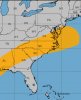
Solid for a GOM landfall
Not sure how the NHC comes up with these wind history maps but the ENTIRE state of NC is covered bythe TS wind history.
Attachments
I hope the bird man is ok:
We'll find out on November 1. Stay tuned!
Henry2326
Member
Power went out at 4 am this morning....no ETA. West side of Atlanta.
accu35
Member
There is one gas station in my town that's open with power and let me tell ya, that coffee was good
Dewpoint Dan
Member
Does walmart have power ?There is one gas station in my town that's open with power and let me tell ya, that coffee was good
Henry2326
Member
Hahaha....my new go-to....Racetrac....super coffee barThere is one gas station in my town that's open with power and let me tell ya, that coffee was good
Dewpoint Dan
Member
QT is betterHahaha....my new go-to....Racetrac....super coffee bar
Henry2326
Member
Lol....I was told thatQT is better
Dewpoint Dan
Member
I like Kum and Go also but QT is my faveLol....I was told that
The roar of a tornado that is very close, 75-100 yards away, is unmistakable, and something I never want to experience again!Last night was incredible. The first big thing was a possible mesovort in the remnant eyewall. I saw the flash of the transformers in the distance, I then heard trees popping. I will never forget the roar. I’ve never personally have heard a tornado, but the freight train rumble sent chills up my spin and had me running for porch door. I could hear it moving closer and then move away. Whether or not it touched down I don’t know, but I’ll remember that sound forever.
The second and main event happened after the remnant eyewall moved by. I’ve never seen winds as strong as that. I have little doubt we had sustained winds of 35-45mph with gusts over 60mph if not close to 70mph. It actually looked like a hurricane outside.
Tons of trees are down and the whole area still has many power lines down. All in all, Zeta didn’t disappoint.
accu35
Member
Like 2 hours agoDoes walmart have power ?
Jessy89
Member
Question can zeta be retired even though it was from the Greek alphabet?
Sent from my iPhone using Tapatalk
Sent from my iPhone using Tapatalk
Brent
Member
Last night was incredible. The first big thing was a possible mesovort in the remnant eyewall. I saw the flash of the transformers in the distance, I then heard trees popping. I will never forget the roar. I’ve never personally have heard a tornado, but the freight train rumble sent chills up my spin and had me running for porch door. I could hear it moving closer and then move away. Whether or not it touched down I don’t know, but I’ll remember that sound forever.
The second and main event happened after the remnant eyewall moved by. I’ve never seen winds as strong as that. I have little doubt we had sustained winds of 35-45mph with gusts over 60mph if not close to 70mph. It actually looked like a hurricane outside.
Tons of trees are down and the whole area still has many power lines down. All in all, Zeta didn’t disappoint.
That's crazy sounding and I was looking at the Alexander City obs last night because that was also the closest to my parents and they gusted to 62 at least and over 45 mph for 2 hours
The forecasts definitely verified there
Question can zeta be retired even though it was from the Greek alphabet?
Sent from my iPhone using Tapatalk
That's a good question we probably won't know til the spring meeting of the WMO but what I'm wondering more broadly is if there will be a push to ditch the greek names for some other method(going to numbers or another regular list etc) especially if we have another significant hurricane which definitely can't be ruled out looking at the models
Brad P mentioned something about this as Delta was approaching the coast. The name Zeta won’t be retired, but on the retired name list it would be listed as Zeta-2020Question can zeta be retired even though it was from the Greek alphabet?
Sent from my iPhone using Tapatalk
Snowflowxxl
Member
Winds are really howling tonight
NoSnowATL
Member
I will note
Im getting stronger winds with this front then I did with the storm.Winds are really howling tonight
There are crazy winds in Lawrenceville! Not as scary as this morning but probably close to it. So much for getting any sleep tonight! Ya'll be safe!
I will not
Im getting stronger winds with this front then I did with the storm.
I didn’t lose power with Zeta, but I just did. Unbelievable.
Looks like the mesos were on to something...

Henry2326
Member
Good luck....just got an ETA on the west side for 11/1 at 11 pm.I didn’t lose power with Zeta, but I just did. Unbelievable.
GA power restored power to 490,000 today. There is 280,000 left to fix. A friend in Buckhead got a message for middle of next week. Multiple transformers blew out in the city.
NewnanWetather
Member
Just got our power back in Newnan Ga. It was out for 18 hours and 2 minutes.Good luck....just got an ETA on the west side for 11/1 at 11 pm.
GA power restored power to 490,000 today. There is 280,000 left to fix. A friend in Buckhead got a message for middle of next week. Multiple transformers blew out in the city.
Oh no Tornado Warning!!
