Shaggy
Member
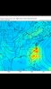
GEFS sends a lot of members directly over Hispaniola
View attachment 45297
Until we have a bonafide center I'm cautious of modeling. A reformation north of south even by marginal distances can play havoc.
GEFS sends a lot of members directly over Hispaniola
View attachment 45297

My concern for this system is slowly growing from meh to hmmmmm........being in eastern NC ( 100 miles due west of Hatteras) some of these tracks are interesting....with a large wind field even a center miss 50-100 miles west would make for a windy wet day.....

This system is already over 1 degree south of its forecast point by the NHC. Lol
This system is already over 1 degree south of its forecast point by the NHC. Lol
I guess with that out the window goes the overall weak storm west strong east idea. If it rides the islands someone's getting slammed if going by that.
For those two that lean into the Gulf, if we keep seeing that trend, we can see a really strong storm as it would have longer time in the gulf with westward trends. Riding the islands would also cause it to stay weak and not get lifted north until the Gulf when it stops riding constant mountains. Yes I'm sort of going on 2 members but it's not a good look to see if the other day nothing was hitting land. For all we know tomorrow we could see most of the members end in the gulf and blow up, or all of them ride Florida. Regardless, it's a complex situation and needs to be watched.How do you figure? Half the tracks don’t even develop
Gotcha. Yeah I’m so anxious to see where it’s at come Thursday morningFor those two that lean into the Gulf, if we keep seeing that trend, we can see a really strong storm as it would have longer time in the gulf with westward trends. Riding the islands would also cause it to stay weak and not get lifted north until the Gulf when it stops riding constant mountains. Yes I'm sort of going on 2 members but it's not a good look to see if the other day nothing was hitting land. For all we know tomorrow we could see most of the members end in the gulf and blow up, or all of them ride Florida. Regardless, it's a complex situation and needs to be watched.
This is a pretty significant shift west. Notice a good chunk of members run over Hispaniola.
This is a pretty significant shift west. Notice a good chunk of members run over Hispaniola.


I think this thing could very well end up in the center of the gulf before it said and done


first sign of a little strengthening winds are up and pressure is down 1 mb(recon is out right now)
SUMMARY OF 200 AM AST...0600 UTC...INFORMATION
----------------------------------------------
LOCATION...14.9N 60.3W
ABOUT 50 MI...80 KM ENE OF MARTINIQUE
ABOUT 450 MI...725 KM ESE OF SAN JUAN PUERTO RICO
MAXIMUM SUSTAINED WINDS...45 MPH...75 KM/H
PRESENT MOVEMENT...WNW OR 295 DEGREES AT 25 MPH...41 KM/H
MINIMUM CENTRAL PRESSURE...1006 MB...29.71 INCHES
The GEFS went back east but again without a center this is guesswork
View attachment 45323
HWRF is into eastern Florida as a weak cane
View attachment 45324

Yeah who knows at this pointHopefully the HWRF, as is often the case, is on crack. Meanwhile, a much better model, the King, has only a weak low in the SE GOM:
View attachment 45325
Yeah who knows at this point
I don't think we'll know much til it clears Hispaniola

Is this where the center is?
View attachment 45326


Gfs ensembles still up the coast?