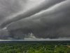
• Hello, please take a minute to check out our awesome content, contributed by the wonderful members of our community. We hope you'll add your own thoughts and opinions by making a free account!

Tropical Hurricane Isaias

Brad P was spot on. This storm was very PATHETIC in Charleston.
Like that in Summerville today...
Strongest gust may have been 25mph and mostly light rain... sun came out nefore sundown too...
The sun shining on the edge of Isaias revealed a nice mammatus field at the edge...
 
KLTX overshooting tops, intentional or not, does appear we will have a strengthening storm up to landfall in the next couple hours. Picking up 110mph pixels on the super res vel scans on the NE side.
 
Like that in Summerville today...
Strongest gust may have been 25mph and mostly light rain... sun came out nefore sundown too...
The sun shining on the edge of Isaias revealed a nice mammatus field at the edge...
Yeah I'm in Mount Pleasant and I would say the highest wind gust was probably 35 or 40mph. And same here the sun came out at the very end..
 
KLTX overshooting tops, intentional or not, does appear we will have a strengthening storm up to landfall in the next couple hours. Picking up 110mph pixels on the super res vel scans on the NE side.

Currently at our place on OKI. If landfall projections are correct, I’ll be on that NE side shortly. We’ll find out!
 
KLTX overshooting tops, intentional or not, does appear we will have a strengthening storm up to landfall in the next couple hours. Picking up 110mph pixels on the super res vel scans on the NE side.

real question is what does that translate to on the ground when the center is over central NC.....how does this deepening into landfall impact the potential winds...just how crazy are the wind clown maps....I am guessing folks from I-95 to Hwy 17 see a period of 4-5 hrs of gust 50-75 mph....I guess a few places could see higher in the event the mystical and rare "sting" jet comes into play though I dont think that is likely this far south....still PGV will gust higher than it did in Flo or Dorian ( low 50's).....maybe even Irene ( 73)........
 
James Island as well. The high wind gust was like 40 mph or so. Maybe 1” or so of rain. Needed a good soaking rain like this, but pretty much was limited to daylight only. 8-9 hours.

There have been thunderstorms with more rain than that in a hour here this year.
 
Looking at the webcam at the campground I stay at in North Myrtle and it looks like it is flooding.

 
Any GIS folks out there? Looking for a map service that only shows tropical watches and warnings. The current NWS service has all weather types. Using services from weather.gov/gis
 
Back
Top