NBAcentel
Member
Um, yikes
View attachment 46006

GREAT work by one of our very own! Congrats Webb!
GREAT work by one of our very own! Congrats Webb!
Got my rain gear ready, just drank a pot of coffee......bring it onnnnnnnnnn....
Radar loop looks like I will be east sided the whole time with the center 20 miles to west....MBY might not get the center at all but only by a little bit, basically what Jim Cantore is standing in right now is going to come over Pitt Co in 4 hrs....but will it be that bad away from the water....

I made the 6 hr drive to PGV hahaha
NWS going hardcore upping the wind gust forecast View attachment 46010
The drive only works in Jan/Feb and even times is suspect.

It’s hard to beat the dwarf triplets when it comes to short range modeling. They’re the DGEX of the mesoscale world.Those are my favorite snow models!
We need @SD to go over and drop a comment “Shelby, keep politics out of the storm discussion thread. Thx.”Then there’s people like this that just want to ruin your day View attachment 46009
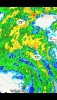
Things are taking off in northeast North Carolina tornado wise.View attachment 46011
005
WTNT64 KNHC 040359
TCUAT4
Hurricane Isaias Tropical Cyclone Update
NWS National Hurricane Center Miami FL AL092020
1200 AM EDT Tue Aug 4 2020
...1200 AM EDT POSITION UPDATE...
...EYE OF ISAIAS MOVING INLAND OVER SOUTHEASTERN NORTH CAROLINA...
A weather station on Johnny Mercer Pier at Wrightsville Beach,
North Carolina, recently measured sustained winds of 62 mph (100
km/h) and a gust to 76 mph (122 km/h).
A sustained wind of 47 mph (76 km/h) and a gust to 74 mph (119
km/h) was recently reported at Wilmington, North Carolina.
SUMMARY OF 1200 AM EDT...0400 UTC...INFORMATION
-----------------------------------------------
LOCATION...34.2N 78.3W
ABOUT 30 MI...45 KM W OF WILMINGTON NORTH CAROLINA
MAXIMUM SUSTAINED WINDS...85 MPH...140 KM/H
PRESENT MOVEMENT...NNE OR 20 DEGREES AT 22 MPH...35 KM/H
MINIMUM CENTRAL PRESSURE...988 MB...29.18 INCHES
$$
Forecaster Brown/Berg

Made a serious NE turn unless it's just a wobble, HRRR determined it turns back north and comes right up 95


.png")

Looks like another tornado on the ground with this one.