Belle Lechat
Member
- Joined
- Aug 29, 2021
- Messages
- 1,705
- Reaction score
- 1,371




 www.ventusky.com

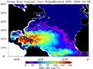
Not to mention, the storm will be traversing an eddy in the GOM with high oceanic content this evening.Agreed, I think next 12 hours this can def get to cat 3

I agreeThe faster it speeds up, the further west it’s going….i wouldn’t be shocked to see this coming onshore in MS.
Yeah, I noticed that. I think the GFS was the further west.12z models have def come further East!
Sent from my iPhone using Tapatalk
I'm of the opposite opinion. The faster the forward speed, the less influence westward from the building H5 ridge in the SW Atlantic. And one could argue less capture by the developing ULL to the NW.The faster it speeds up, the further west it’s going….i wouldn’t be shocked to see this coming onshore in MS.
I'm of the opposite opinion. The faster the forward speed, the less influence westward from the building H5 ridge in the SW Atlantic. And one could argue less capture by the developing ULL to the NW.

Your right. Stronger it is the farther east she’s going. Clear to seeI'm of the opposite opinion. The faster the forward speed, the less influence westward from the building H5 ridge in the SW Atlantic. And one could argue less capture by the developing ULL to the NW.

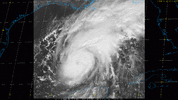
Cool. Thanks for posting that link!Theres a web cam out in central GOA. Station 42001 off ventusky website.
Webcams - Station 42001 - MID GULF - 180 nm South of Southwest Pass, LA
See the weather like never before – live weather maps powered by the most accurate models.
| Wind Direction (WDIR): | E ( 100 deg true ) |
 Wind Speed (WSPD): Wind Speed (WSPD): | 31.1 kts |
| Wind Gust (GST): | 36.9 kts |
| Wave Height (WVHT): | 6.2 ft |
| Dominant Wave Period (DPD): | 7 sec |
| Average Period (APD): | 4.5 sec |
| Mean Wave Direction (MWD): | ENE ( 63 deg true ) |
| Atmospheric Pressure (PRES): | 29.67 in |
| Air Temperature (ATMP): | 79.9 °F |
| Water Temperature (WTMP): | 85.6 °F |
| Dew Point (DEWP): | 76.3 °F |
| Heat Index (HEAT): | 85.1 °F |
| Wind Speed at 10 meters (WSPD10M): | 33.0 kts |
| Wind Speed at 20 meters (WSPD20M): | 35.0 kts |

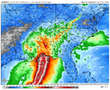
Pretty much every 12z ticked east -- esp. the hurricane models. All now have Florida landfall with HMON east of Destin.12z Euro ticked east View attachment 198612
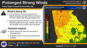

Interesting that the winds look to be stronger in North GA than in South GA. Is that due to higher elevations in the north ?

The pressure gradient from the wedge will be greatest in N. Georgia.Interesting that the winds look to be stronger in North GA than in South GA. Is that due to higher elevations in the north ?
That is blessing right?It's amazing that a storm that is "getting its act together" and has "an eye clearing out" and is "ready to pop" ... hasn't lost any pressure in the last 5 or so hours. In fact last recon pass was up 2 mb to 978mb.
It is for me.That is blessing right?
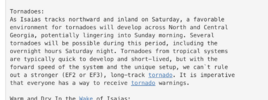

Tornadoes: Due to the slight westward shift of the track, more of
the rain bands will progress over our area. The tornado threat
would begin early Saturday morning when the first bands approach.
This threat would continue through Saturday evening until the
remnants of Isaias progress out of the area. The fly in this
ointment is as the approaching shortwave trough phases with
Isaias. There is a low chance that this may stall over the TN
Valley, which would prolong the tornado threat. There is a medium
to high chance at least portions of our area will be in a tornado
watch on Saturday.

