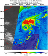
It seems the storm gulped a bit of dry air in the wee hours. It also looks like D-min is helping the storm to mix it out. A big convective burst has gone up right over the center.



So because the storm center will pass by that evening, we are going to put everyone in harms way prior to the game. You can’t even make this up.SEC officials, Alabama and Georgia are proceeding as if Saturday’s football game between the Crimson Tide and Bulldogs will kick off as scheduled at 6:30 CT in Tuscaloosa, while monitoring developments with Hurricane Isaias in case any late changes need to be made.
The storm was upgraded to a hurricane on Thursday morning and is expected to make landfall along the Alabama Gulf Coast Friday night. But updated forecasts say the speed of the storm will likely take it past Tuscaloosa, which is about 200 miles inland, by Saturday evening.
The storm itself still looks dangerous for the Gulf Coast, but its recent increase in speed makes it more likely it will be clear of Tuscaloosa by kickoff.
The most concern for the game would be if the storm were to slow down, but there isn’t much chance of that anymore, according to Chad Merrill, a senior meteorologist at AccuWeather.
“It looks like if anything it would be a hair faster,” Merrill said on Wednesday evening.
That also could mean slightly more severe impacts on the Tuscaloosa area, just earlier in the day.
“While the weather looks like it’s going to improve in the evening Saturday, there will be quite a bit of rain, some power outages, and the potential for tornadoes,” Merrill said.
And even if the worst of the storm avoids Tuscaloosa, current projections make the game conditions less than ideal. There could still be rain, plus winds of around 30 mph, with gusts potential double that.
Moving to Sunday afternoon is an option, and Georgia has done that before. Ten years ago, its game at South Carolina was moved from Saturday night to Sunday at 2:30 p.m. because of Hurricane Matthew. Officials made the decision on Thursday of game week after the storm strengthened to a Category 4 hurricane. And while Columbia, S.C., is about three hours inland, the need for state troopers to help with hurricane-related security and relief also figured into the decision.
As for other potential sites: Atlanta’s Mercedes-Benz Stadium, site of the SEC championship, is hosting an MLS match Saturday.
Could the game be moved to Athens? If it’s out of the storm path, that’s always an option. It would also mean Alabama would only have three home SEC games this year.
—————————
One person in comments below suggested this:
Alabama is scheduled to play Texas A&M on October 24. Both teams have a bye on October 31. Move the Bama v. A&M game to the 31st and move Bama v. Georgia to the 24th. Everyone keeps their home games that way, avoids serious weather this weekend, and the game doesn't get moved out of Tuscaloosa or to Friday or Sunday.

The major threat inland is tornadoes to the right of the center of circulation. It's not a big deal as the models weaken the wind field quickly.So because the storm center will pass by that evening, we are going to put everyone in harms way prior to the game. You can’t even make this up.

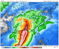
It seems like they are putting all their focus into the conditions during the game itself and not considering the dangers that people may face trying to get to the game. I’ve seen wind maps showing 60 mph+ winds in Tuscaloosa which could do a lot of damage.So because the storm center will pass by that evening, we are going to put everyone in harms way prior to the game. You can’t even make this up.
Agree. Even with the fast-forward motion, those who wind up under those training bands will get copious rainfall.I have to believe that with such a strong dry punch of air/interaction with the upper low that heavy training cells will be interesting to watch in Georgia. One would thinknthe models are underestimating totals in ga
It seems like they are putting all their focus into the conditions during the game itself and not considering the dangers that people may face trying to get to the game. I’ve seen wind maps showing 60 mph+ winds in Tuscaloosa which could do a lot of damage.

James Spann said this morning that the worst of the storm should be clear of the Tuscaloosa area by noon Saturday and he felt much better about playing the game as scheduled.So because the storm center will pass by that evening, we are going to put everyone in harms way prior to the game. You can’t even make this up.
IDK if we're ever going to clear out the eye with the ongoing shear, but a well-organized eye is most certainly hidden under the canopy.
View attachment 198601
View attachment 198600
James Spann said this morning that the worst of the storm should be clear of the Tuscaloosa area by noon Saturday and he felt much better about playing the game as scheduled.
AgreeI agree with Spann that that’s looking more likely as almost all of the globals have continued to speed up the movement to the point where the center gets by their latitude by ~noon-1PM CDT. Thus I continue to lean toward them playing there on time as most of the afternoon would even be ok for tailgating
-However, what if there’s a lot of damage and outages there in the morning? Wouldn’t that be a major problem?
-Are state troopers going to be extra busy especially in S AL making their availability for the game limited?
 I think currently the only factor that would affect playing the game as scheduled is power outages and down trees affecting traffic flow. He also mentioned that the game day broadcast setup would make a decision tonight and would likely move indoors.
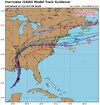
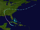
Same path of CamilleEarly model track guidance: good consensusView attachment 198602

Nah. Camille came in at Bay St. Louis on the extreme west side of Mississippi after brushing Boothville, LA. The landfall is closer to where Hurricane Frederic made landfall.Same path of Camille
I mean the whole path with the sharp right turn and a path over the Appalachians though a touch more northNah. Camille came in at Bay St. Louis on the extreme west side of Mississippi after brushing Boothville, LA. The landfall is closer to where Hurricane Frederic made landfall.
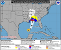
TS Watches up for inland AL/GA View attachment 198603

Agreed, I think next 12 hours this can def get to cat 3Its definitely organizing at least steadily looking at IR. Finally seeing visual banding around the eyewall.

Wouldn't be surprised. That's usually how it's been the past decade or so with hurricanes blowing up quickly.Agreed, I think next 12 hours this can def get to cat 3


Probably be much stronger winds towards Mobile area if we blend it with the other models that are further west.
Definitely seems to lineup with the many reports in past few hours that it seemingly has really pulled together. It's concerning because we have seen in very warm waters like in the Gulf right now system really blow up big in past definitely think Cat 3 is not out of picture at least before approaching landfall and weakening. Bottomline is the more amped it is the longer it will take to weaken and more inland impact will be felt as wellVery impressive for the NW eyewall.

Heading straight over your house.Probably be much stronger winds towards Mobile area if we blend it with the other models that are further west.