Downeastnc
Member
Yikes

GFS gets it back this closeGuess the looping back around and striking East Florida solution is no longer in the cards?

So about the pop up cells this evening…I feel pretty safe in saying that if you dont see rain from pop up storms this evening and you're north of 85 in the triangle, you may not see more than a couple tenths at best.


I was looking right at it from Wilmington driving home from work, couldn’t tell where it was exactly but knew it was somewhere in front of me, probably closest I’ve ever been to one. I was expecting carnage with every passing intersection. My heart was pounding it was scaryYikes
It's completely ridiculous. What are we even doing?Wake County schools closed tomorrow for 1 to 2 inches of rain.
If it gets that right let's see if it gets those winds right as well. Had some decent gust pretty far inlandUnless my eyes are deceiving me, it seems the NAM may be on to something. Heavy axis of precip is working its way into wake now

And they wonder why the kids are struggling with math.. I’ll be quiet, I know it’s banter.Wake County schools closed tomorrow for 1 to 2 inches of rain.
Maybe they were confused and thought it was snow.It's completely ridiculous. What are we even doing?
Maybe they were confused and thought it was snow.
They’re not closed due to the rain I’m sure. I think the concern is the modeling that’s showing 50mph wind gusts at a time in which school buses would be on the road.Wake County schools closed tomorrow for 1 to 2 inches of rain.
They’re not closed due to the rain I’m sure. I think the concern is the modeling that’s showing 50mph wind gusts at a time in which school buses would be on the road.
Meh, I don't think it's going to be anything here but a little rain.Yeah kinda rude to make kids stand at a bus stop in driving rain and TS force gust.....
Personally I would have put it on a two-hour delay and then if the high wind materialized you can make the call to closeYeah kinda rude to make kids stand at a bus stop in driving rain and TS force gust.....
Been getting some decent winds here. It's quiet then all of a sudden a decent gust will rock the house. Sitting at just over 5 inches of rain.Center just moved off Bald Head Island & Cape Fear coast proper..
current obs
RAIN Winds
N @ 25MPH GUST too 38
Pressure 29.42 in
Visibility X
Clouds Cloudy
TEMP 73F
Dew Point 72 F
Humidity 94 %
Rainfall (ALOT)
They must have some built in snow days and realized they will not need them for that, better burn'em while they canGot 2" rain here with a gust to 22 last night.
Glad they closed school for a partly sunny day with a nice, fresh autumn breeze.
Got 2" rain here with a gust to 22 last night.
Glad they closed school for a partly sunny day with a nice, fresh autumn breeze.


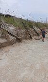
Went to Johnnie mercer pier at Wrightsville Beach today and the dunes were destroyed. Waves were still large and shell hunting was awesome.Solid 2 ft surge here in NMB View attachment 136715
Don't think I'll be swimming
View attachment 136716
What happened was it started to weaken before landfall and wind usually underperforms when that happens. It clearly had a cat3 pressure at landfall.@lexxnchloe & everyone..
Idalia WAS NOT a *CAT 3*..
A CAT ONE..
Yes, it hit as a Cat3 - supposedly. EXCEPT: Perry, which from the radar that morning looks to have taken the eyewall in the face, only has reports of Cat 1 wind GUSTS. So where are the Cat3 winds? The screaming about it being a 4 or even worse was incessant for days. It didn't happen and from what I can see even the claims of a 3 are --------; the reported wind speeds from the ground supported a Cat 1, which is exactly what I expected would happen. Why didn't the monster everyone claimed was "muuuh~global~warming" happen?
The NHC printed several sustained wind numbers; I didn't see triple-digit ones in their list anywhere, including in places that the eyewall absolutely did hit, such as Perry.
In other words,, as with everything else these days its fake, gay, and catastrophized.
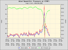
THINK.. THIS, was BARELY a hurricane. Maybe. Keaton Beach, the NHC and screamers forget, has a NOAA weather station. The eyewall made landfall at Fish Creek about 2 miles from there; I watched it on radar yesterday morning. Here's the pressure and wind from the station, which did not fail at any time during it.
MEH ya'll "wonder" why I don't post on that *other* board..
It’s also important to remember that the areas that likely saw the highest winds have no weather stations there. If this had gone say straight into Appalachicola or Carrabelle, it’s very likely that there would have been recorded wind gust well within category 3 range. Also, Perry did take a direct hit from the eyewall, but it’s also important to remember that it’s not a coastal town… it’s a ways inland and that would decrease the winds especially with the storm weakening right before landfall due to the EWRC. Everything about this storm, satellite representation, pressure readings, storm surge, and reconnaissance info says it was a category 3 at landfall.What happened was it started to weaken before landfall and wind usually underperforms when that happens. It clearly had a cat3 pressure at landfall.
I agree.It’s also important to remember that the areas that likely saw the highest winds have no weather stations there. If this had gone say straight into Appalachicola or Carrabelle, it’s very likely that there would have been recorded wind gust well within category 3 range. Also, Perry did take a direct hit from the eyewall, but it’s also important to remember that it’s not a coastal town… it’s a ways inland and that would decrease the winds especially with the storm weakening right before landfall due to the EWRC. Everything about this storm, satellite representation, pressure readings, storm surge, and reconnaissance info says it was a category 3 at landfall.
It’s also important to remember that the areas that likely saw the highest winds have no weather stations there. If this had gone say straight into Appalachicola or Carrabelle, it’s very likely that there would have been recorded wind gust well within category 3 range. Also, Perry did take a direct hit from the eyewall, but it’s also important to remember that it’s not a coastal town… it’s a ways inland and that would decrease the winds especially with the storm weakening right before landfall due to the EWRC. Everything about this storm, satellite representation, pressure readings, storm surge, and reconnaissance info says it was a category 3 at landfall.