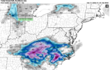
LOL, HRRR just flipped off everyone in NC from Triad to 95.
-
Hello, please take a minute to check out our awesome content, contributed by the wonderful members of our community. We hope you'll add your own thoughts and opinions by making a free account!
You are using an out of date browser. It may not display this or other websites correctly.
You should upgrade or use an alternative browser.
You should upgrade or use an alternative browser.
Misc General Banter Thread
- Thread starter Rain Cold
- Start date
blueheronNC
Member
Public trust in weather forecasting will never recover if 4 million people in NC get blanked when under a Winter Storm Warning.Why can't we go one model cycle without a model showing Raleigh getting blanked in a dry slot?Today's 12z 3km NAM and 18z HRRR have been brutal
BHS1975
Member
That mesolow is jacking it up.
Thrasher Fan
Member
Raleigh has had some brutal misses over the years, but January 10-11, 2011 was one of the most infuriating. In that storm much of the Southeast scored with mostly snow, but Raleigh only ended up with a dusting of snow and a glaze of ice.
January 3-4, 2018 was a brutal dryslot for the Triangle, but the ULL snowfall to the west was somewhat unexpected and it was unclear if RDU would get any snow at all.
January 3-4, 2018 was a brutal dryslot for the Triangle, but the ULL snowfall to the west was somewhat unexpected and it was unclear if RDU would get any snow at all.
BrickTamland
Member
BrickTamland
Member
I would never believe we are ever going to get snow again.Public trust in weather forecasting will never recover if 4 million people in NC get blanked when under a Winter Storm Warning.
broken025
Member
Need to go change my Raleigh total to 0.0
NWG_WX14
Member
I’m not buying the HRRR yet until it gets some more support. Right now the 3k and the HRRR are on an island
BrickTamland
Member
And why can't we get some kind of consensus on the models less than 24 hours out? The difference between some of them is ridiculous.Why can't we go one model cycle without a model showing Raleigh getting blanked in a dry slot?Today's 12z 3km NAM and 18z HRRR have been brutal
WxBlue
Meteorologist
This didn't age well.Okay, the panic over Raleigh seems ridiculous. 4-6" was always the floor and I still feel good with that. We're basically gambling on the coastal WF and I can accept 4-6" if we miss on a chance of getting 12" if we can get that WF over us. Sometimes that's the game if you want to chase after weenie amounts.
BrickTamland
Member
Insert obligatory Dec 2000 reference here
i literally see a major reason for my house to get 3 inches total while everywhere within a mile does 5+
cant wait
the winds gonna zip on up over my house and dry it out; i feel it.. i need the ULL further south
cant wait
the winds gonna zip on up over my house and dry it out; i feel it.. i need the ULL further south
rburrel2
Member
You live in Pickens county too?i literally see a major reason for my house to get 3 inches total while everywhere within a mile does 5+
cant wait
the winds gonna zip on up over my house and dry it out; i feel it
That happened last weekend, this will just be icing on the cake.Public trust in weather forecasting will never recover if 4 million people in NC get blanked when under a Winter Storm Warning.
BrickTamland
Member
Wave hasn’t been sampled yet
Wait…are we not getting 10”?
SnowNiner
Member
Hrrr is unreliable past 10 hours if that. Just follow the rgem imo.
I don’t know, same principle for me. For the ULL if your not under a great meso low band, light precip. If under it, pretty good totals. Then the coastal will likely do work for Raleigh and east…
I don’t know, same principle for me. For the ULL if your not under a great meso low band, light precip. If under it, pretty good totals. Then the coastal will likely do work for Raleigh and east…
NCPROGRAMMER
Member
Yep, game over for RDU area. NAM and HRR are now in better agreement. We just can not get a good snow here since 2018. So many ways to fail and our annual snow average keeps going down.
a bad run of the HRRR is not game over for our area.........Yep, game over for RDU area. We just can not get a good snow here since 2018. So many ways to fail and our annual snow average keeps going down.
blueheronNC
Member
“Right now the two most advanced and skilled short-term models are on an island about the event transpiring in the short-term”I’m not buying the HRRR yet until it gets some more support. Right now the 3k and the HRRR are on an island
NCPROGRAMMER
Member
NAM is going this way as well.a bad run of the HRRR is not game over for our area.........
BrickTamland
Member
JimBobs
Member
Generational, once in a lifetime, measuring in feet... etc etc
If we get blanked in the Triangle area, Mods -please delete my account. Thank you in advance
rburrel2
Member
3km NAM gonna be a pants buster, holy smokes.
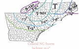
T might be generous. What else you got?made a small last second change to my call map. GL boysView attachment 191953
All kidding aside, I'm not buying the HRRR. But it's theraputic to get it out of the system. 
coldspringsfarm
Member
Any recommendations for websites/apps for multi state radar composites (bonus if it has realtime weather station data)? The NWS radar solution is a laggy POS. I have radarscope on my phone but snow can be tricky with single radar stations. Been using Wundergrounds wundermap...is that still the best thing going for my needs?
blueheronNC
Member
HRRR + now the 3km NAM, both with only a dusting in the Triangle. This event is collapsing.
my sleetboard got warped sitting outside all week.
i think they'll be ultimately be fine but a little worried for raleigh
blueheronNC
Member
Thinking I definitely prefer WAA events where it's about warm nose and precip. changeover. These wildly variant outputs so close to the event, we really have no idea what's going to happen until game time.
Iceagewhereartthou
Member
Upstate just got NAMed!


