Mahomeless
Member
- Joined
- Oct 17, 2023
- Messages
- 900
- Reaction score
- 2,158
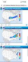
It's wild to think that anyone is giving credence to the CMC or Weathernext2 AI models with them running a weak SLP right into the heart of a 1040+ HP.....it just doesn't happen that way.


 lol
lol

