-
Hello, please take a minute to check out our awesome content, contributed by the wonderful members of our community. We hope you'll add your own thoughts and opinions by making a free account!
You are using an out of date browser. It may not display this or other websites correctly.
You should upgrade or use an alternative browser.
You should upgrade or use an alternative browser.
Misc General Banter Thread
- Thread starter Rain Cold
- Start date
TigerSnow
Member
I know a lot of folks don’t like Brad P but he has a good break down of the storm potential he just put out. Looks like he is back from vacation and it’s not AI, lol. I’ve always respected him and think he does an excellent job. He knows the climate pretty well around here.
shoalswxlady
Member
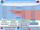
I got a question. If the temperature is in the 20's when a winter event start, what makes up have freezing rain, sleet instead of snow? Might be a crazy question but want to know.
broken025
Member
Brent
Member
I got a question. If the temperature is in the 20's when a winter event start, what makes up have freezing rain, sleet instead of snow? Might be a crazy question but want to know.
The upper levels. If there's any warm air aloft it's ice instead. Doesn't matter what the surface is
Has to be cold throughout for snow to survive
This is a pretty cool graphic from the NWS about it
Freezing rain is literally just rain that hits something freezing... It's the worst kind of precip to exist. Even sleet is better

Last edited:
GeorgiaGirl
Member
Oh you don't say.
I didn't post this, but it was a thought I was keeping to myself, I was thinking that the GFS AI is so off its rocker that I would discount it for now. The Euro AI is probably closer to the right idea, along with the Weathernext.
shoalswxlady
Member
Thanks Brent. You explain it well and graphic help a lot. I understand now.The upper levels. If there's any warm air aloft it's ice instead. Doesn't matter what the surface is
Has to be cold throughout for snow to survive
This is a pretty cool graphic from the NWS about it
Freezing rain is literally just rain that hits something freezing... It's the worst kind of precip to exist. Even sleet is better
View attachment 185603
I see the GFS AI still is like his counterpart
LukeBarrette
im north of 90% of people on here so yeah
Meteorology Student
Member
2024 Supporter
2017-2023 Supporter
OP models kicking ass let’s go
Cindy131
Member
Pretty sure that was not record breaking snow. They had 16.5 inches of snow back in Feb 1973. 5.5 inches of snow on Feb 10 1973. There have been bigger daily accumulation amounts higher then 5.5 inches.
Bigedd09
Member
The mid west crew in shambles. They no longer haw their precious AIGS on their side . At least as on now
Sent from my iPhone using Tapatalk
Sent from my iPhone using Tapatalk
Brent
Member
Pretty sure that was not record breaking snow. They had 16.5 inches of snow back in Feb 1973. 5.5 inches of snow on Feb 10 1973. There have been bigger daily accumulation amounts higher then 5.5 inches.
I think they mean daily record as in that day on the calendar..
Drizzle Snizzle
Member
I'm pretty sure they mean broke the Daily Record for January 18.Pretty sure that was not record breaking snow. They had 16.5 inches of snow back in Feb 1973. 5.5 inches of snow on Feb 10 1973. There have been bigger daily accumulation amounts higher then 5.5 inches.
i can't stress this hard enough. today is the day to go to costco. this is about to break containment. my friends are texting me. THE DAY TO GO TO COSTCO IS TODAY
GFS with pounding snow at 24 degrees Saturday afternoon imby. That's a shame. D5 bullseye always works out, right?
@tractor girl , correct me if I’m wrong but I thought at least right now both Euro AI and WeatherNext show at least an ice storm for Atlanta and especially areas to the north.He's using dinosaur data and his tune will change when the legacy globals bow to the AI suites
Alias47
Member
I'm in North Alabama and I know this isn't our storm. However, do I need to ramp up any supplies? Not really wanting to spend any extra money this week, if not necessary.
WolfpackHomer91
Member
Look idk who these losers are or how they keep ending up on my TL. Between him and All the other Northern guys just wishcasting this thing North so that it ends up in their city’s is hilarious to me. Like people actually believe this character has a degree from Penn State ?
Sent from my iPhone using Tapatalk
Unless they were referring to the date.Pretty sure that was not record breaking snow. They had 16.5 inches of snow back in Feb 1973. 5.5 inches of snow on Feb 10 1973. There have been bigger daily accumulation amounts higher then 5.5 inches.
LukeBarrette
im north of 90% of people on here so yeah
Meteorology Student
Member
2024 Supporter
2017-2023 Supporter
Bigedd09
Member
View attachment 185638
Can’t wait to see this X/twitter here shortly. “North trend is happening”
Hahaha I was just thinking the same thing
Sent from my iPhone using Tapatalk
BHAMWX
Member
Awesome ! Thanks for posting !The upper levels. If there's any warm air aloft it's ice instead. Doesn't matter what the surface is
Has to be cold throughout for snow to survive
This is a pretty cool graphic from the NWS about it
Freezing rain is literally just rain that hits something freezing... It's the worst kind of precip to exist. Even sleet is better
View attachment 185603
ForsythSnow
Moderator
Luckily the CMC has a bad track record recently so hopefully the Euro sides more with the GFSView attachment 185638
Can’t wait to see this X/twitter here shortly. “North trend is happening”
Should be in Ohio the next run.View attachment 185638
Can’t wait to see this X/twitter here shortly. “North trend is happening”
Cindy131
Member
It must have been for the date. I did not think of it. As a kid I was so jealous that south of me got a lot snow (16 in) and I got the 4 inches of ice. Timeframe was only weeks apart.Unless they were referring to the date.
WolfpackHomer91
Member
View attachment 185638
Can’t wait to see this X/twitter here shortly. “North trend is happening”
I’m sorry …. There seems to be so may weeniers that became X famous from DC - Maine. They post degrees in their Bio so people follow, idk I mean this with the upmost disrespect too….. if you’re a met in the NE especially like Boston / NE / CT ect dude your job is so easy like that’s a rookie gig the should send the students to full time. Every storm it’s so easy “ohhh man here’s cold air, yep there comes QPF here ya go a snowfall map”. Like I said Rookie stuff, anyone could do it. But down here the actually have to EARN clout and respect bc the geography, the setup, the timing, their mothers maiden name EVERYTHING has to be perfect not just “welp yep it’s always cold here comes the Liquid”. So yea anyone up there annoys the fool outta me bc I feel like I could’ve done their job as a 14yr old hobbyist. Same with Bastardi, and Rayno …. Both are losers and have been for 2 decades that I’ve been following weather since I was 14, I’ve never seen either of the be correct anymore than that Dude in Richmond DT that gets picked on yearly lol . These cats are so mindlessy stupid they’re manipulating people into thinking a Low is gonna plow right through a once in a season HP ….. for clicks lol. And no other region Wishcast more than MA-NE. Again this is meant with total disrespect and I’ve posted it in their forum before just to stir the pot and then leave and watch the get all upset. So yea I mean it lol
Sent from my iPhone using Tapatalk
Last edited:
ChattaVOL
Member
I'm in North Alabama and I know this isn't our storm. However, do I need to ramp up any supplies? Not really wanting to spend any extra money this week, if not necessary.
I think this is very much your storm.
Sent from my iPhone using Tapatalk
ducketta27
Member
This may be better for the banter thread... these looks are giving me Feb 2014 vibes for those of us in the i20 corridor from Augusta to Columbia. This is likely to be an all rain or freezing rain event for us here. I'm leaning towards all rain at the moment... but definitely wondering if preparing anyway would be worth it. 2014 was not fun without power for 10 days.This is the kind of pattern I used to dream about for southern slider type events, though this obviously looks a bit on the amped side of things. A giant polar vortex over Ontario & Quebec to supply brutally cold air into the CONUS & a SW US upper low to feed warm/moist air aloft to overrun this arctic air is usually how you get it done for the I-20 & I-40 crews
View attachment 185595
Drizzle Snizzle
Member
This is going to be a Suppressed system when it's all over with. Snow and Ice from Houston to Jacksonville, FL.
I don’t see this site surviving if that happensThis is going to be a Suppressed system when it's all over with. Snow and Ice from Houston to Jacksonville, FL.
Brent
Member
This is going to be a Suppressed system when it's all over with. Snow and Ice from Houston to Jacksonville, FL.
Absolutely not y'all have stolen enough snowstorms
This ain’t be suppressed to Penscola in the this stormWell I keep seeing people talk about Suppressed. Suppressed isn't good for the I-40 corridor is it ?
GeorgiaGirl
Member
I spy several GEFS panels that have a sorry folks, the southeast US is closed vibe.
In all honesty, I'm not interested in the icy ones.
In all honesty, I'm not interested in the icy ones.
I totally agree. I did see some snowier solution for ATL though. At this point, give me rain.I spy several GEFS panels that have a sorry folks, the southeast US is closed vibe.
In all honesty, I'm not interested in the icy ones.
Drizzle Snizzle
Member
Speaking of Dr. King. Happy MLK Day to you and everyone else !Let's see what King has to say in a few! I like the fact that the EURO (Dr. No or King) is the last model to complete the model suites
Bigedd09
Member
Banter cause it’s the Canadian but here’s the end of the run

Sent from my iPhone using Tapatalk

Sent from my iPhone using Tapatalk
- Joined
- Jan 5, 2017
- Messages
- 3,771
- Reaction score
- 5,974
I'm going with the Ukie for the weekend storm. Much more of a tornado threat than an ice storm.
Drizzle Snizzle
Member
With the last system people were Trash Talking the GFS saying it was a horrible model. And now people wanna Hug the GFS and pretend that it's right ?

