-
Hello, please take a minute to check out our awesome content, contributed by the wonderful members of our community. We hope you'll add your own thoughts and opinions by making a free account!
You are using an out of date browser. It may not display this or other websites correctly.
You should upgrade or use an alternative browser.
You should upgrade or use an alternative browser.
Misc General Banter Thread
- Thread starter Rain Cold
- Start date
@bouncycorn .....can you show your model run?
why the hell did i stay up til 2am talking ai models with bouncycorn i feel awful today
I wonder the same thing about staying up to read it.why the hell did i stay up til 2am talking ai models with bouncycorn i feel awful today
Brent
Member
why the hell did i stay up til 2am talking ai models with bouncycorn i feel awful today
Me who got home from work at 630am wondering when I will go to bed haha
I hear that whistle coming, it's coming round the bend, I know it is the failboat, coming to do me in.
6 pages overnight discussing the 0z GFS with is in the process of flatlining today. We need some real snow really bad.
Temps are just a killer.
Temps are just a killer.
GFS coming back to reality.
Bigedd09
Member
In about ready to call this one over for the western piedmont. Good luck to those in eastern nc. Euro suite is untouchable
Sent from my iPhone using Tapatalk
Sent from my iPhone using Tapatalk
Bigedd09
Member
6 pages overnight discussing the 0z GFS with is in the process of flatlining today. We need some real snow really bad.
Temps are just a killer.
It’s the freaking precip. Heavy precip would rapidly cool the column and produce nice snow in the western Carolina’s . QPF has been our biggest issue for quite sometime
Sent from my iPhone using Tapatalk
Hold.
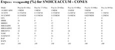
@bouncycorn off hand, do you know the % of weight the GFS and GEFS has in the NBM suite vs other globals? I feel like the NBM really leans heavily into the american guidance first and foremost, then euro, cause you know.. america
In about ready to call this one over for the western piedmont. Good luck to those in eastern nc. Euro suite is untouchable
Sent from my iPhone using Tapatalk
Nah. The next time they show snow, the GFS will whip e'm like it's nothing.
@bouncycorn off hand, do you know the % of weight the GFS and GEFS has in the NBM suite vs other globals? I feel like the NBM really leans heavily into the american guidance first and foremost, then euro, cause you know.. america

Brent
Member
I guess if this is going to fall apart it's better to do it now believe me
GeorgiaGirl
Member
Hold.
I want that run to be right so bad...or at the very least, have some support join it.
That said, I have to wonder about temps too. It took a while for the cold to work its way here today. As depicted, it works, but just...idk.
wowzers, did not expect that for the 3KM NAM
NoSnowATL
Member
I don’t believe youI guess if this is going to fall apart it's better to do it now believe me
ChattaVOL
Member
Had some hope last night... it's all gone.
I'm sure it will be back soon just to be crushed again..
I'm sure it will be back soon just to be crushed again..
I never in the least expected the GFS to be correct. I don't know how or why people get so excited about what that model shows. It is utter Garbage. It showed me 5 inches in one run. Two and a half, Next run, Now it's getting in line with the euro, With nothing back this way. I fully expect flurries at best at the moment. Unless the euro starts throwing precip, the far NW and I don't expect that. Did I mention I hate the GFS!6 pages overnight discussing the 0z GFS with is in the process of flatlining today. We need some real snow really bad.
Temps are just a killer.
accu35
Member
I’ll still pay attention to the short range models from here on out. I really don’t buy this east solution just yet. As Webb mentioned many times past day or so these type of storms normally start trending NW close to go time and there’s nothing that’s stopping it from doing that.
Why all the sudden negativity? Just from the perspective of tracking these storms over the years and not as a trained meteorologist, I would NOT want to be sitting right near the rain/snow line 2-3 days out like what’s been shown on the GFS recently. The precipitation shield is probably going to extend further NW than depicted like always, so seeing that shift to the southeast at this stage should be a welcome sight for I-85, not doom?
Analysis data is available hourly (ERA5), so I’m sure we’ll have hourly-output AINWP models soon.One thing annoying about the AI models is how they are only at 6hr increments. I believe that’s because they are partly based on reanalysis data which is in 6hr increments. Anyway, was wondering bouncy (or others) if there will be future efforts to upgrade to 3hr etc?
The current models output with a 6hour interval because 6-hour intervals score the highest with the current model architectures used.
Things don’t work like they used to. Doom.Why all the sudden negativity? Just from the perspective of tracking these storms over the years and not as a trained meteorologist, I would NOT want to be sitting right near the rain/snow line 2-3 days out like what’s been shown on the GFS recently. The precipitation shield is probably going to extend further NW than depicted like always, so seeing that shift to the southeast at this stage should be a welcome sight for I-85, not doom?
Bigedd09
Member
Why all the sudden negativity? Just from the perspective of tracking these storms over the years and not as a trained meteorologist, I would NOT want to be sitting right near the rain/snow line 2-3 days out like what’s been shown on the GFS recently. The precipitation shield is probably going to extend further NW than depicted like always, so seeing that shift to the southeast at this stage should be a welcome sight for I-85, not doom?
I’m honestly just more bummed about the lack of QPF for mby. Everything has trended weaker and flatter today. That’s not gonna cut it
Sent from my iPhone using Tapatalk
The difference is that AIFS and WeatherNext have barely budged an inch, and are even further southeast - and from what I understand they haven't exhibited that kind of "last minute NW trend" that the older versions/models used to.Why all the sudden negativity? Just from the perspective of tracking these storms over the years and not as a trained meteorologist, I would NOT want to be sitting right near the rain/snow line 2-3 days out like what’s been shown on the GFS recently. The precipitation shield is probably going to extend further NW than depicted like always, so seeing that shift to the southeast at this stage should be a welcome sight for I-85, not doom?
No give up here, I’ll go down with the ship. Lot of time left
LukeBarrette
im north of 90% of people on here so yeah
Meteorology Student
Member
2024 Supporter
2017-2023 Supporter
Reel it in Mitch!
Peak cinema here would be the Euro coming NW while everyone on I-85 is cliff diving
Even with no NW trend in the track, I feel like the extent of the precipitation shield has been further NW than depicted on models in the past in these types of storms. Maybe misremembering.The difference is that AIFS and WeatherNext have barely budged an inch, and are even further southeast - and from what I understand they haven't exhibited that kind of "last minute NW trend" that the older versions/models used to.
We punt.Well what’s next?
Bigedd09
Member
There’s a reason why we’re in a major storm. I full expect this storm to be very weak with little precip except for maybe eastern nc down to Georgia
Sent from my iPhone using Tapatalk
Sent from my iPhone using Tapatalk
GeorgiaGirl
Member
The difference is that AIFS and WeatherNext have barely budged an inch, and are even further southeast - and from what I understand they haven't exhibited that kind of "last minute NW trend" that the older versions/models used to.
The GFS is actually in alignment apparently with the AI, the big problem is that it's too warm for almost everyone.
They probably actually have a point. It took a while for the cold to bleed towards the east today.
Our only hope is this shifts like last year. I don't know when the models will actually lock on the correct amount of moisture but it's really frustrating.Peak cinema here would be the Euro coming NW while everyone on I-85 is cliff diving
At what point do the models start getting a better idea on how much overrunning will occur? Last year places near Atlanta didn't show anything until the last minute.Analysis data is available hourly (ERA5), so I’m sure we’ll have hourly-output AINWP models soon.
The current models output with a 6hour interval because 6-hour intervals score the highest with the current model architectures used.
the precip will arrive earlier than forecast anyways; so not having the cold already in place was a major red flag. never does it work out in my yard without an arctic front already through, 99/100 times
- Joined
- Jan 23, 2021
- Messages
- 4,602
- Reaction score
- 15,197
- Location
- Lebanon Township, Durham County NC
The other modelling coming back to a euro like solution. How could this have ever been predicted?

