ForsythSnow
Moderator
So far just over 2.5" here from all this rain and more on the way.
Storming pretty good here in ATL. Two days in a row with thunderstorms in February.
Same here. Already had two power surges as well. Quite intense.Just creepy outside. Sleet yesterday, then massive thunder and lightning off and on, and now its thundering so loud the entire house is shaking. Still holding at 42F.
Atlanta got like 20+ inches of rain in that event, so I would say very unlikely


So my rain gauge overflowed overnight because I forgot to empty it (it was at around 3.75" when I last saw it) so I'm guessing I'm now at about 6" per that. Starting fresh with an empty gauge that should finish up the event. The models were right before hand about all this rain,Yet again, another tight gradient across Metro Atlanta.
Folks in McDonough and Covington are like "what thunderstorms and flooding?" lol.
View attachment 16120

Only one I saw was parts of Colbert County had 12+We've had a ton of rain here in Florence AL... I think we may be over 10" for the storm total. But just to our north and west the training of the rain has been even worse. Does anyone have access to the storm totals for Florence AL? Booneville MS? Iuka MS? Selmer TN? Savannah TN? and Lawrenceburg TN?


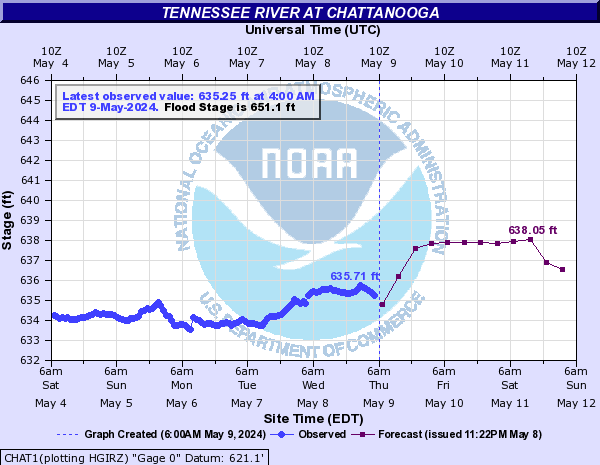
It's been a moderate to heavy rain here off and on for several hours now. The radar returns in my area have been showing mainly scattered showers but in reality it has been coming down hard. There is also a new flood warning for Hamilton county due to more than 1" of rain received in the last 3 hours. As I'm writing this the rain seems to have let up a lot. When it gets completely out of here late morning I guess we will wait for tonight to see if any developing storms to our west make it to our area. If we do get a storm I feel like it will be short lived with another . 25" of rain possible under the heavy bands of rain. Looks to be pretty dry for the next week or so starting tomorrow morning after sunrise.
Sent from my XT1710-02 using Tapatalk