Webberweather53
Meteorologist
1” of snow reported in the last hour near Lewisville


I hope you're right. I don't get the best feeling about it honestly. I'd like to see the radar respond a little better over the next hour.I feel like the northern part in NC is going to die off fast... But I think the SC portion is going to cook b/c it's get the meso-low/frontal boundary going for it. I-26 heading to columbia and the greenwood area gonna get smoked, imo.
Yea that Corridor of Western Rowan - Troutman and up through @Frosty absolutely got hammered with that Pivot good fortuneYep, same look. But we lucked out on that one with the pivot and that little line just sat on us for hours. That was a nice surprise after the disappointing totals the day before when the sleet came in quick.


Considering you have an hour left to go with heavier rates coming... definitely a win.This a win? I’m torn View attachment 171079

Radar shows it weakening over upstate SC now. This a NC show I'm afraid.Considering you have an hour left to go with heavier rates coming... definitely a win.
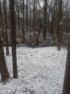
We had some pretty big flurries falling when I left the house at 6am.Wasn’t expecting anything near ATL so this is a win for the NW sideView attachment 171074

U mean to tell me CNC might just score on back to back systems? Although tbf the triad already getting it good with snow850 mesolow west of Charlotte, but I do like how 850 frontogenesis is setting up over Central NC! View attachment 171078

cornReflectivity
Sent from my iPhone using Tapatalk


Most of the snow this morning over NC is right along or near the 850mb cold front. As usual, due to greater terrain blocking, the arrival of this low level cold advection was delayed in upstate SC, which is why snow is struggling to crank there.
Eventually, even in NC, mass subsidence from cold advection will win out against frontal lifting and shut off the precipitation.
Hence, why this is a burst of snow that will only last a few hours or so
View attachment 171083
View attachment 171084
 I hope that band holds together to make it to MBY but I don’t have my hopes up.
Absolute insanity how my iredell/meck was in the bulleye for this and they heaviest band still finds a way to find greensbor and eastern nc, rich get richer. I'll take my tiny flakes im getting now thoughMost of the snow this morning over NC is right along or near the 850mb cold front. As usual, due to greater terrain blocking, the arrival of this low level cold advection was delayed in upstate SC, which is why snow is struggling to crank there.
Eventually, even in NC, mass subsidence from cold advection will win out against frontal lifting and shut off the precipitation.
Hence, why this is a burst of snow that will only last a few hours or so
View attachment 171083
View attachment 171084
You think it will hold together and translate east or dry up?The snow is heavier up into northern NC and Virginia because you’re closer to the DGZ at the 850mb level, in addition to some better help from the vort max aloft.
That’s why the bullseye doesn’t mean much with these, they’re just impossible to predict where the bands will setup until the last minute. I think that band will probably fall apart some as it heads east, so I doubt it’s going to bullseye Eastern NC.Absolute insanity how my iredell/meck was in the bulleye for this and they heaviest band still finds a way to find greensbor and eastern nc, rich get richer. I'll take my tiny flakes im getting now though
its been pouring snow here for 1.5hrs.... Ive gotten around an inch from this. Storm Total dang near 1.8 - 2" ( Call it 2 on your map please @Webberweather53)Absolute insanity how my iredell/meck was in the bulleye for this and they heaviest band still finds a way to find greensbor and eastern nc, rich get richer. I'll take my tiny flakes im getting now though