They sure do know how to program the models to keep the NatGas traders off balance!
Cold will be back in the picture before you know it.
Dewy is that you?


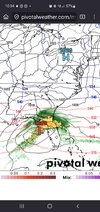
Hopefully we can start getting something to track again. I have the itch for one more. What am I supposed to do at work all day if I can log on here and see the latest model run?The system valentines weekend is quite the signal. With the pattern structure and time of year it doesn't take significant changes to move that from winter to severe and vice versa. Certainly one to watch right now.
Otherwise though quite the hostile trend on the lastv72 hours. Warning shots probably should have been the double troughs on the extended model but what can you do.
The system valentines weekend is quite the signal. With the pattern structure and time of year it doesn't take significant changes to move that from winter to severe and vice versa. Certainly one to watch right now.
Otherwise though quite the hostile trend on the last 72 hours of models. Warning shots probably should have been the double troughs on the extended models but what can you do.
Someone on this board is going to be tired of precipitation by mid March. I would assume it's you, mack or the TN postersYeah I've already seen posts here about it could be severe weather or snow depending on where you live
But other people are like it's not happening on the cold side anyway
I just want something to track soon it's way way too early for warm and dry...
Someone on this board is going to be tired of precipitation by mid March. I would assume it's you, mack or the TN posters


Looks like the period around mid-month might be interesting for AL/GA. Some hints of a gulf low. Not sure if it will be cold enough, though.The sad thing about the coming Eastern CONUS warmup is that even if we return to a favorable pattern beyond mid-month, we are going to lose most of the gorgeous Midwestern snowpack, making it that much more difficult to score in the deep South as winter wanes.

yeah. The cold is back north and west at this point and seems if we do see a big storm around this time period it seems it would favor the Ohio valley maybe into the NE. Wouldn’t eliminate the upper mid south or WNC just yet. I like the idea that cold rushes back in to the east for a period after this. Maybe the last hoorah for us.
I have a parade the 14th. Hopefully that thing will either speed up or slow down. Nobody wants to throw beads in a rain poncho.
Maybe I need to play this weekend. All those balls I generally hit in the ole pond, would skid on across.Golf course ponds are all completely frozen over
Last time was probably 2018 if memory serves me View attachment 193517
Would have saved my son a couple of strokes had that been frozen last time we played out there.Golf course ponds are all completely frozen over
Last time was probably 2018 if memory serves me View attachment 193517


Likely will be possibly Severe weather threat for the SE. If I had to bet, Our Winter weather is overMid-month looks like a west to east slider set up with high likelihood of wedging. Question is whether or not a storm tracks far enough south for us to win. Cold air source region also doesn’t look ideal but it’s still workable with a favorable track and wedging.