Love that super dark blue area that moves over RDU at the end.
12z RGEM suggesting wintry precip for parts of NC Wednesday night/Thursday morning
Sent from my iPhone using Tapatalk
-
Hello, please take a minute to check out our awesome content, contributed by the wonderful members of our community. We hope you'll add your own thoughts and opinions by making a free account!
You are using an out of date browser. It may not display this or other websites correctly.
You should upgrade or use an alternative browser.
You should upgrade or use an alternative browser.
Pattern Fab Feb
- Thread starter SD
- Start date

CNCsnwfan1210
Member
12z RGEM suggesting wintry precip for parts of NC Wednesday night/Thursday morning
Sent from my iPhone using Tapatalk

While we have maybe a couple more lemons in the table, might as well make use of them
Sent from my iPhone using Tapatalk
Cad Wedge NC
Member
Got down to 4 degrees this morning. Been a while since we have had lows this cold.
Bigedd09
Member

While we have maybe a couple more lemons in the table, might as well make use of them
Sent from my iPhone using Tapatalk
It has actually slowly been trending slightly better across some modeling
Sent from my iPhone using Tapatalk
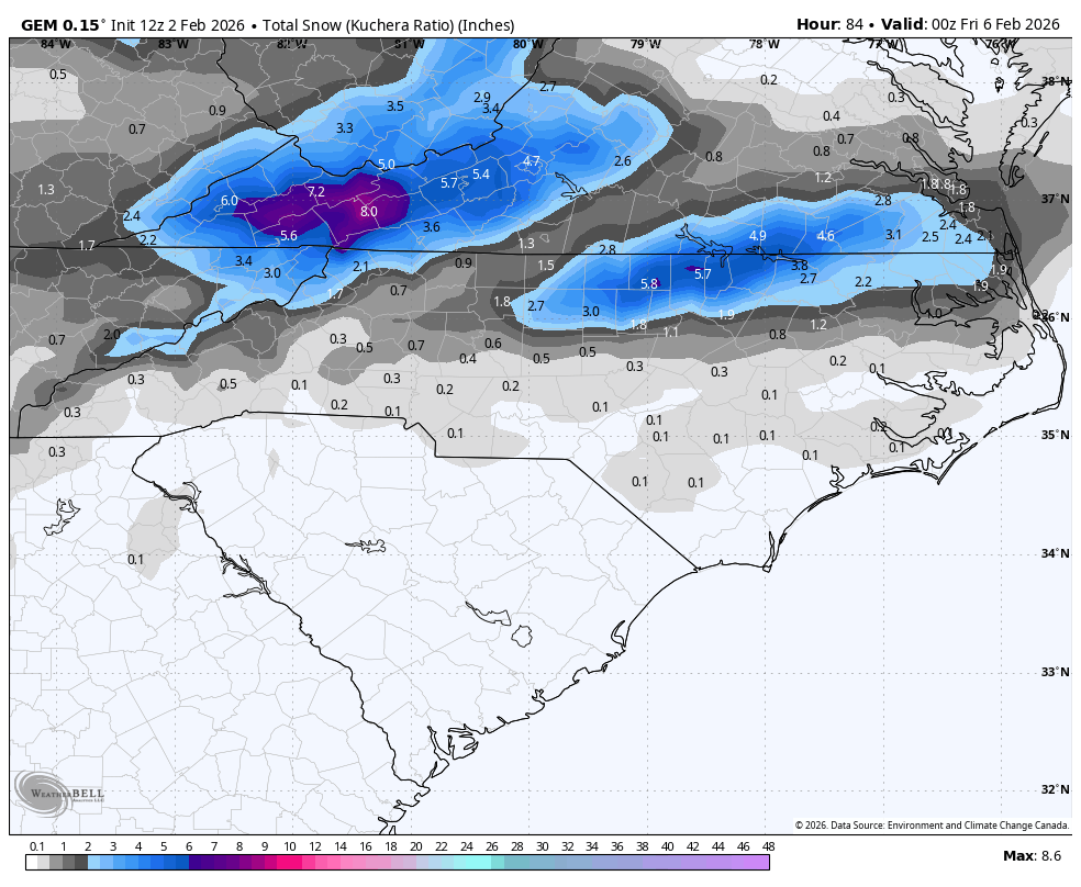
1"+ / hr rates in that one.Love that super dark blue area that moves over RDU at the end.

And this is Kuchera. RDU has 3" on the 10:1 maps. Would be absolutely hilarious, and typical, if this trends into a bigger storm than this past weekend for RDU. We back into our better storms.
Definitely could see this being a Moyock jackpot.

Definitely could see this being a Moyock jackpot.
Bigedd09
Member
Gfs

Sent from my iPhone using Tapatalk

Sent from my iPhone using Tapatalk

CNCsnwfan1210
Member
Gfs
Sent from my iPhone using Tapatalk

GFS trend including more of the Piedmont and central NC
Sent from my iPhone using Tapatalk
GB shooting his shot this morning #NatGas
packfan98
Moderator
I'll make a new storm thread this afternoon after all of the 12z runs are in.
rburrel2
Member
If you just showed me this map I’d say a winter storm is coming?

Thanks! It may not turn out to be anything, but would be good to separate it out from all the pattern discussion!I'll make a new storm thread this afternoon after all of the 12z runs are in.
packfan98
Moderator
@BullCityWx is about to get 2-4" while I get a sloppy coating.

Roxboro jackpot there kind of makes sense.
iwantsouthernsnow123
Member
I'm really just not quite buying into the idea of the meso low forming in NE GA, but it is there on some models I suppose it's something to watch
Bigedd09
Member
I can get behind this

Sent from my iPhone using Tapatalk

Sent from my iPhone using Tapatalk
- Joined
- Jan 23, 2021
- Messages
- 4,604
- Reaction score
- 15,203
- Location
- Lebanon Township, Durham County NC
@BullCityWx is about to get 2-4" while I get a sloppy coating.
Roxboro jackpot there kind of makes sense.

dsaur
Member
We haven't had one sneak up on us a day, day and a half out, for some time. About time for a big dog surprise storm. I don't think the models are good enough now to catch 'em all up close.Looked out through LR. Just looks Ho-Humbug/ seasonal throughout Feb. Might can whip something up mid month. If we score its gonna have to catch some 2 day ripple where everything just lines up right. Pattern is going to start its seasonal shuffling, meaning roller coaster time as winter will start its wind down second half of Feb into early March. The CFS now goes out into the 1st week of March. Looks like the Block stays pretty entrenched up over Greenland for next couple of weeks is about only positive Ive noticed. Pretty much just seasonal wx. Which for most of us outside of elevation equals to avg daytime highs evolving and scooting back up into the 50's.
Pattern chasing is no fun after Groundhog day. You have to look for smaller windows than what you look for Nov, Dec and Jan. Occasionally you get some Like 2013, or that March back in the 1960's. So it's doable, but your better served looking for 3-5 day windows that can yield an opportunity
GeorgiaGirl
Member
I'm going to be honest, low 40s at work on my lunch break feels downright balmy with no wind after the past couple days.
17 this morning. The snow is pretty much gone outside the shade and whatever meager remains...if it can survive at all will be washed away by rain by midweek.
17 this morning. The snow is pretty much gone outside the shade and whatever meager remains...if it can survive at all will be washed away by rain by midweek.
Roofus likes. FV3 doesnt as of yet

If Roxboro somehow gets an additional 6 inches on this I might have to move LMAO
- Joined
- Jan 23, 2021
- Messages
- 4,604
- Reaction score
- 15,203
- Location
- Lebanon Township, Durham County NC
As someone who grew up in a not favored zip code vs now being in a favored zip code, there is no comparison.If Roxboro somehow gets an additional 6 inches on this I might have to move LMAO
Bigedd09
Member
12z EURO

Sent from my iPhone using Tapatalk

Sent from my iPhone using Tapatalk
Raleighwxauthority
Member
It’s always these types that come up on us from behind and end up over performing an surprising a lot of people.
packfan98
Moderator
NEW STORM THREAD HERE!
KSAV had 19 for yesterday’s low, which was a new record. This ties with the 19s in Dec ‘22, Jan ‘18, and Jan ‘14 for the coldest since Jan ‘11’s 18. To put this into even better perspective, the coldest there since 1990 is only a little lower, 17! The last Feb with it this cold was 1996. Only 8 other Febs since 1874 have had a low colder than 19 meaning this is ~95 percentile for a coldest Feb low!
Seen worse
Bigedd09
Member
Euro with some clipper action Friday

Sent from my iPhone using Tapatalk

Sent from my iPhone using Tapatalk
lexxnchloe
Member
And this is Kuchera. RDU has 3" on the 10:1 maps. Would be absolutely hilarious, and typical, if this trends into a bigger storm than this past weekend for RDU. We back into our better storms.
Definitely could see this being a Moyock jackpot.
View attachment 193400

Carolina heat enthusiasts in shambles
Oranges are subject to being ruined if temps are AOB 28F for 4+ hours assuming no adequate protective measures were taken.
Followup: the FCOJ mkt is way down today signifying that FL Orange damage was fortunately likely not widespread enough to have a significant market impact.
GeorgiaGirl
Member
What happened to the 50 inch gfs snow storm a few days ago we need that back
We lost the pattern look that we had that would suggest continuation of what we had for a few weeks after a warm start to the year.
Considering the way winter has gone, I wouldn't write it off completely, but anything beyond the new thread that was created for now would likely have to be CAD related.
- Joined
- Jan 2, 2017
- Messages
- 1,568
- Reaction score
- 4,283
Euro AI through the 17th


Further to the post above:
Today’s Euro Weeklies are, if anything, even worse than yesterday’s if you want a cold pattern in the E US. Also, the 10 mb has pulled up somewhat on the mid Feb reversal chance.
Cue the folks that say the EW shouldn’t run daily lol, which is irrelevant:

Today’s Euro Weeklies are, if anything, even worse than yesterday’s if you want a cold pattern in the E US. Also, the 10 mb has pulled up somewhat on the mid Feb reversal chance.
Cue the folks that say the EW shouldn’t run daily lol, which is irrelevant: