Here we go again,
Sent from my iPhone using Tapatalk
Sent from my iPhone using Tapatalk
Here we go again,
Sent from my iPhone using Tapatalk
MagicI'm saying the precip types on both runs show thunderstorms for NC, not snow, but then they also have snowfall amounts. How is that?
I’m surprised how well this system holds together as it goes through the mountains. If models continue to show that then you can bet there will be some surprises. Models typically underdo moisture getting past the mountains so I’m willing to bet that this will be even better than say what the NAM has right now. Only issue is that it comes in during the middle of the day so I wouldn’t expect much for accumulations.
Don't worry, it will trend west.... has all winter.Scoot everything West & we working with something. View attachment 193719
Deeper trough but positioned way East. Keep the trough locked in & trend it West. We can’t help ourselves this Winter. Winter of the old ways is back.Scoot everything West & we working with something. View attachment 193719
Called it on the first one@ nba central
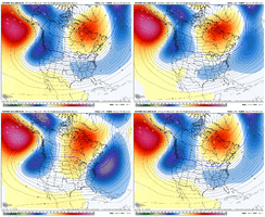
OMEGA BLOCK?
Where do you think it will anchor down at? Those are stuborn boogers. If its central us, canada, then we will be in the dip on the right side. Good times , espeacilly if you get any undercutting from sw.
View attachment 193554
View attachment 193555

He is quick to announce things early, for better or worse. He forecast a dramatic PV to happen around the same time.Glenn Burns calling for severe on Valentine’s Day
I was promised heat? Ya’ll must have access to stuff I don’tView attachment 193727

We about to learn omega block and short springtime wavelengths View attachment 193729View attachment 193730


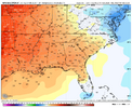
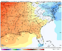
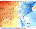
I honestly think the EPS has the better idea here, it’s easier to drop a trough out west and get a west coast/east coast trough with a omega block around this time of the year especially with NATL blocking. After mid Feb though not very sureThere’s significant disagreement between the 12Z EPS (BN to NN) and the 12Z GEFS (NN to AN) for the period 2/13-17 although they agree on AN after that period: GEFS is 3-4F warmer than EPS in SE for 2/13-17
12Z GEFS 2/13-17:
View attachment 193733
12Z EPS 2/13-17:
View attachment 193734
I honestly think the EPS has the better idea here, it’s easier to drop a trough out west and get a west coast/east coast trough with a omega block around this time of the year especially with NATL blocking. After mid Feb though not very sure
The big dog I can recall having that configuration is Feb 2004. Had a centric ridge into Canada and Baffin Bay, with a PNW/GOAK trough, a upper level low undercutting the ridge extending up into the central/northern plains, and a trough hanging out in the NATL/off the EC. March 2018 also had events with a similar configuration. DT calls it the Pamela Anderson patternWhat storms in the past has featured an omega block?
Sent from my iPhone using Tapatalk
The big dog I can recall having that configuration is Feb 2004. Had a centric ridge into Canada and Baffin Bay, with a PNW/GOAK trough, a upper level low undercutting the ridge extending up into the central/northern plains, and a trough hanging out in the NATL/off the EC. March 2018 also had events with a similar configuration. DT calls it the Pamela Anderson pattern
It’s going to try and thunderstorm in the Carolina’s next week.James Baker just said he wonders if it's going to try and snow in the Carolinas again next week...
Getting to the time of the year that it can very easily do bothIt’s going to try and thunderstorm in the Carolina’s next week.
I guess it's all relative, but right now it's 37 at 7:30, and that's a pretty dang good winter day to me. And even if it warms up during the day, it's plenty cold enough for snow at night. So if a slug of moisture moved in and didn't warm the column, it could snow all it wanted. That's a possible piece of an event, so that's a good winter's day for me. Just need more pieces.Not “heat” (that’s an exaggeration) and nothing’s promised, but I do see AN temps on the 12Z GEFS for the period 2/11-17 averaged out, which is what I’d expect with a progged -PNA for that period and would be far different from what we’ve had the last 3.5 weeks: (probably NN near Val Day though)
View attachment 193728
