• Hello, please take a minute to check out our awesome content, contributed by the wonderful members of our community. We hope you'll add your own thoughts and opinions by making a free account!

Pattern Elevation Micro-climatology (SE Mountain Weather)

Nice map, I know it took some time to make it. Yup, some places in western NC is going to get hammered with snow.

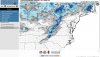
Thanks! It did take some time (about a hour) entering forecast numbers into Excel spreadsheet, importing it into ArcGIS, and generating the snowfall graphic onto the map with few adjustments. Then I had to make it pretty with final touches.
 
The trends are our friend today hopefully we can score something this weekend.
 
Minor icing event poss tonight with winter weather products being considered because of freezing fog all the way down to Wilkesboro. This occurred last night in Virginia and West Virginia with advisories too.
 
Off and on rain snow mix in Jasper, Ga area also. Heavier a little farther north in Ellijay. Nothing sticking. We are about 1385 ft or so here. Elevations vary in the area. Nothing sticking. Temps ranging lower 40s to upper 30s.
 
OK, how many of you out there are staring at the flood lights right now .... raise your hands. The first step is admitting you have a problem, lol
 
OK, how many of you out there are staring at the flood lights right now .... raise your hands. The first step is admitting you have a problem, lol

Hell, I’m all about flood light snowing. Saw four flurries tonight because of it :)


Sent from my iPhone using Tapatalk
 
Talk about a beating. I’m not sure if some ski resorts will be open for the big MLK holiday weekend. 1” in upslope rain now 1-3” additional. And next week looks horrid.
 
Sapphire Ski resort is closed until further notice. Flash flood warnings and warm air last night with lots of lightning. 70s today in lower elevations.
 
Sapphire Ski resort is closed until further notice. Flash flood warnings and warm air last night with lots of lightning. 70s today in lower elevations.

The big names to the north are struggling too.
I won’t be surprised to see sugar completely close for a few days.


Sugar mountain is on the brink...
26DABACC-D3C6-42A0-8080-E3115B1B0929.jpeg

beech mountain is not healthy either. This slope usually is built up and counted by the feet..

EDA7D616-F284-4F3A-AAFB-E26CE6ADAF2C.jpeg
 
Gsp thinks a little ice is possible mtns/foothills if the column moistened up between 12-16z. Nothing major maybe some slicks spots bridges elevated surfaces.
 
Nice chilly day here at shortoff mtn (eascarpment) 47° ill gladly take it too good day to take my new coon dog Bailey for a stroll.
 
Light snow possible above 3500ft maybe some snow mixing in the foothills/NW piedmont 850s are borderline.
 
Ray’s Weather Center not biting yet on this weekend..you can hear the potential in his words though;

“We catch a break Thursday into Friday ahead of low pressure developing in the Gulf before moving into the Southeast. Computer guidance is all over the place. I'm steering the forecast ship for now in the middle on both timing and precipitation type... rain or a wintry mix possible Friday night into Saturday.”
 
Loving the continued idea of a potent system moving through with some solid upslope snows as the low pulls out..some solid numbers could be posted if this general idea can hold 6B04E060-BBE0-4AB0-BE8F-A66E8C94CCB2.png
 
&&

...THE FORECAST FOR ROAN MOUNTAIN AT 6285 FT...

.TONIGHT...Cloudy. Snow likely. Snow accumulation around 1 inch. In
the clouds most of the night. Lows in the upper 20s. West winds
25 to 30 mph...decreasing to 20 to 25 mph after midnight. Gusts up
to 54 mph.
.MONDAY...Cloudy. Snow likely. Snow accumulation around 3 inches. In
the clouds all day. Highs in the lower 30s. West winds around
15 mph...increasing to northwest 20 to 25 mph in the afternoon.
Gusts up to 40 mph.
.MONDAY NIGHT...Mostly cloudy until midnight...then becoming partly
cloudy. A chance of snow showers. Little or no snow expected. Lows
in the mid 20s. Northwest winds 20 to 25 mph. Gusts up to 39 mph.
I've seen extreme weather on that mtn from -20° with 20ft drifts no jk 09-10 I believe pushing a foot in the ole powerstroke it was around -17° too if memory serves me right.
 
Snow flying at 4000ft and above. I like the Thursday system for the Mountains and foothills better though best shot all winter below 3500ft imho stay tuned.
 
Ukie and Canadian both showing love Sunday on the back side
F6CCD807-FFE4-4D7B-AFF0-B1BDCF8B94BF.jpeg
4C6E8298-DC10-450C-BBF5-0CF39AEE9116.jpeg
 

Attachments

  • 562A5844-0090-4491-B8C4-9C13A10D941D.jpeg
    562A5844-0090-4491-B8C4-9C13A10D941D.jpeg
    572 KB · Views: 5
NAM still says game on for the mountains....

View attachment 32489
And still snowing..I need help..I don’t know how serious to take this. I know flakes are going to fly up around Beech and sugar some time this weekend but NAM is all alone here..I’m not sure what to expect at this point 7FD32605-6FBF-49EF-93FC-1D2306F7DFC4.png
 
And still snowing..I need help..I don’t know how serious to take this. I know flakes are going to fly up around Beech and sugar some time this weekend but NAM is all alone here..I’m not sure what to expect at this point View attachment 32492

Its still long range NAM so don't even look at it. 12km is WAY colder than 3km which is a red flag although 3km is very bad outside 48hrs.

Give it another day then come back and see what we have.
 
Appalachian Trail Over Hump, Big Yellow and Roan Mountains Balds in December 2019

Absolutely fantastic 1 hour video and rendering of the experience of being in the AT with snow cover and above the clouds.

Few are blessed to experience this in summer and even fewer in winter.

It is truly the best the NC High Country has to offer. Heaven at its best.

Kudos to the fellow who put this together
Enjoy

 
WINTER STORM WARNING ⚠️
URGENT - WINTER WEATHER MESSAGE
National Weather Service Morristown TN
1037 AM EST Wed Feb 26 2020

Cocke Smoky Mountains-Blount Smoky Mountains-
Sevier Smoky Mountains-
Including the cities of Hartford, Cades Cove, Elkmont,
and Gatlinburg
1037 AM EST Wed Feb 26 2020

...WINTER STORM WARNING IN EFFECT FROM 4 PM THIS AFTERNOON TO
7 AM EST THURSDAY...

* WHAT...Heavy snow expected. Total snow accumulations of 4 to 8
inches, mainly at elevations above 2500 feet, with locally
higher amounts possible over the highest elevations. Winds
gusting as high as 35 mph at times.
 
Back
Top