Another 1.11” today after 1.45” yesterday. 11.55” for the month.
-
Hello, please take a minute to check out our awesome content, contributed by the wonderful members of our community. We hope you'll add your own thoughts and opinions by making a free account!
You are using an out of date browser. It may not display this or other websites correctly.
You should upgrade or use an alternative browser.
You should upgrade or use an alternative browser.
Pattern Dry July 2024
- Thread starter SD
- Start date
MamaJen
Member
Before and after pics of the storm that came thru here in southeast Bartow county, GA this evening. It looked pretty threatening at first, but ended up being pretty much nothing here, despite being severe warned. Here at my place, we have gotten some rain the last week or two, but nowhere near what most have gotten lately around here, and certainly not enough in my local area. 
 The frustration of summer stormy weather!
The frustration of summer stormy weather!Iceagewhereartthou
Member
This evening View attachment 148923
Attachments

Well probably had over two inches today, the driveway is toast. No sense in blading it until it dries out.
I got .32 inches of rain yesterday to add to what has turned out to be one of the rainiest months in recent memory. We certainly needed the rain after the drought in May and June.
Another 1.07” for me yesterday… I’m now up to 12.87” for the month.
Triplephase93
Member
Decent storms hitting Kentucky, Tennessee, western NC.
Last edited:
I collected another .53 inches of rain in the rain gauge while I was at work today. I haven't kept track but I believe that I have received rain eight out of the past ten days here. July has been anything but dry.
Drizzle Snizzle
Member
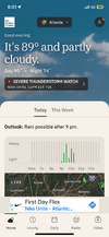
I wouldn’t be surprised if a Severe Thunderstorm Watch is issued in North Georgia soon.
ForsythSnow
Moderator
Just happened. I'm not surprised given the system coming inI wouldn’t be surprised if a Severe Thunderstorm Watch is issued in North Georgia soon.
I wouldn’t be surprised if a Severe Thunderstorm Watch is issued in North Georgia soon.
Attachments
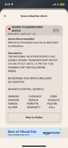
Pretty strong north winds with it but barely any lightning. Did pick up another quick .5”.I wouldn’t be surprised if a Severe Thunderstorm Watch is issued in North Georgia soon.
TullyHeel
Member
Wonder if the storms to the west can hold together and make it here tonight.
A buddy in Talking Rock can’t make it home with all the trees down. Power is out too.
Doubt itWonder if the storms to the west can hold together and make it here tonight.
A buddy in Talking Rock can’t make it home with all the trees down. Power is out too.

We got the rare double box  dumping
dumping JHS
Member
We got pounded here tonight. That storm had the worst lightning I have seen in a long time, but thankfully it got no closer than about a mile from me. It was still close enough to be scary though, and was constant for about 20 minutes.
I just had a rumble of thunder probably registered about a 5 on the Richter scale… lol. It’s been absolutely dumping rain for the last 20 minutes..: heaviest downpour of the month and it may put me over 14” for July.We got pounded here tonight. That storm had the worst lightning I have seen in a long time, but thankfully it got no closer than about a mile from me. It was still close enough to be scary though, and was constant for about 20 minutes.
Here we go again!
GAZ116>119-SCZ047-048-051-312115-
COASTAL CHATHAM-INLAND CHATHAM-INLAND BRYAN-COASTAL BRYAN-INLAND
JASPER-COASTAL JASPER-BEAUFORT-
434 PM EDT WED JUL 31 2024
...STRONG THUNDERSTORMS WILL IMPACT PORTIONS OF BRYAN, CHATHAM,
BEAUFORT AND JASPER COUNTIES...
AT 434 PM EDT, NATIONAL WEATHER SERVICE DOPPLER RADAR INDICATED
STRONG THUNDERSTORMS ALONG A LINE EXTENDING FROM NEAR GODLEY STATION
TO FORT MCALLISTER, AND MOVING EAST AT 15 MPH.
HAZARD...STRONG WINDS 45 TO 55 MPH.
SOURCE...RADAR INDICATED.
IMPACT...EXPECT MINOR DAMAGE TO TREE LIMBS AND BLOWING AROUND OF
LIGHT, UNSECURED OBJECTS.
SOME LOCATIONS IN THE PATH OF THESE STORMS INCLUDE...
POOLER, BLUFFTON, RICHMOND HILL, TYBEE ISLAND, WILMINGTON ISLAND,
FORT PULASKI NATIONAL MONUMENT, BELLINGER HILL AREA, AND MIDTOWN
SAVANNAH.
Heat Advisory out for tomorrow. Heat index could get to 107.
Due to much faster movement than recent storms, the strong effects from this one lasted only ~15 minutes. However, the wind from this at the start was probably the strongest yet of the many July thunderstorms here. The rain was torrential and the combo of that with wind strength/direction actually blew in some water under the door into the foyer. The short duration prevented major street flooding. I’ll check my rainfall later.
Edit: I got ~1” and that was mainly from 15 minutes of torrential downpours.
Edit: I got ~1” and that was mainly from 15 minutes of torrential downpours.
Last edited:
- Joined
- Jan 5, 2017
- Messages
- 3,769
- Reaction score
- 5,966
Received nearly 60 mph wind gusts from the storms last night. About a half an inch of rain. Got another 1" today. 13.44" for July will be close to the total. It's still raining, though.

Average High: 87.1
Average Low: 71.5
Physical gauge: 9.5"
KATL
Average High: 90.7
Average Low: 74.0
Rain: 14.02"
KPDK
Average High: 90.3
Average Low: 70.9
Rain: 8.21"
Yesterday’s thunderstorm could easily have qualified as severe imho due to high winds near the start. I can’t recall the last time I had a puddle just inside the foyer due to the wind blowing so hard (evidently right toward the door) allowing it to sneak underneath despite it being a pretty tight space. Also, whereas I didn’t lose power, I saw a good number of traffic lights that were still out a couple of hours after the storm not too far from me.
Yesterday’s rainfall at my place ended up at ~1”. That gave me a grand total of ~12.25” for July. What a stormy and wet month! This was the wettest month here since the similar 13.25" during August of 2022 (not that long ago).
Just since July 19th, I got ~9.25”! The last time it was this wet here during that short a period was the 10” I got Sept. 1-10, 2022. June through Sept. 10 of 2022 was incredibly wet here, pushing the water table all of the way up, which lead to AC condensation drain line backup.
Inside the house I had a hottest of ~88 for the month and probably for all-time due to no AC for a couple of days.
Max 96.4
Min 58.1
Avg 79.2
Rain 11.08
9798 lightning strikes on the tempest
Min 58.1
Avg 79.2
Rain 11.08
9798 lightning strikes on the tempest
ImpressiveMin 58.1
Brent
Member
We ended up below normal for July somehow
Max 100.9
Min 64.9
Avg 80.2
Rain 8.79
One of the coolest (by average temp) in the past ten years.
Min 64.9
Avg 80.2
Rain 8.79
One of the coolest (by average temp) in the past ten years.
GoDuke
Member
July 1, 2024 - July 31, 2024
| High | Low | Average | |
|---|---|---|---|
| Temperature | 103.4 °F | 56.4 °F | 80.1 °F |
| Dew Point | 80.7 °F | 53.7 °F | 72.2 °F |
| Humidity | 98 % | 30 % | 79 % |
| Precipitation | 5.81 in | -- | -- |
LickWx
Member
Your average seems low…. HmmmMax 96.4
Min 58.1
Avg 79.2
Rain 11.08
9798 lightning strikes on the tempest