Marginal... if that energy ejects out and there is some northern stream interaction it's doable. Small window of opportunty.How's temps looking for this possible event!


Sent from my SM-G920V using Tapatalk
Marginal... if that energy ejects out and there is some northern stream interaction it's doable. Small window of opportunty.How's temps looking for this possible event!

For you, lol.... now I get the slap in the face from the other side.That cold in the plains looks fun lol

Curse that awful SE ridge! It is even stronger on the 12Z GEFS vs earlier GEFS.
That's the kind of cold that stays in the plains!That cold in the plains looks fun lol
. We don't get cold like that in the east and SE anymore! That could be highs in lower 20 in AR and Mo, while the Carolinas and GA, bask in 70s
That’s one of those horrible sharp cut off cold spells I was talking about, I’m sure Arkansas will have highs in the 20’s with snow/ice while not super Far East I will be in the 70’s.That's the kind of cold that stays in the plains!
Not one, other than for nonsecular reasons ...IF the 12Z GEFS were to be right (and I'm still hopeful it will be very wrong), poor Phil would have to suffer with a 587 dm 500 mb height on Christmas. What kind of Christmas is that?
Not understanding the gloom over the long range guidance. I'm encouraged by it. Long range pattern fits in nicely with predicted MJO Phase 7 analogs for December. Which means the atmosphere is responding nicely to MJO forcings and not La Nina, which should weaken as we head into next year. If the MJO can make it to Phase 8, which guidance has been trending towards over the past few days but is still a long ways out, then there should be even better patterns ahead.
And what comes after Phase 7? Phase 8...
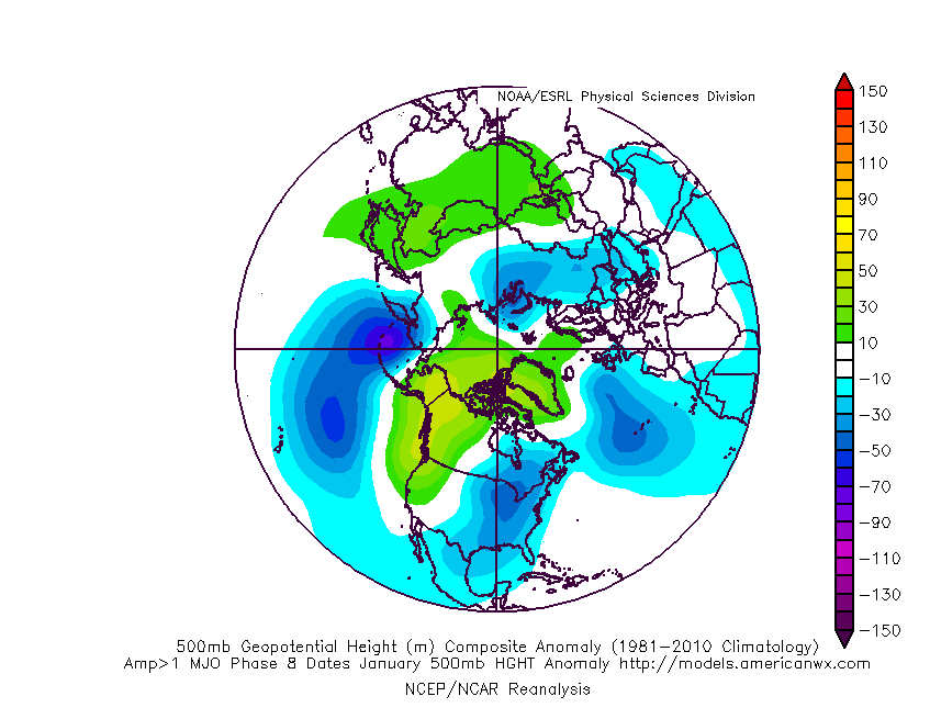
January could be fun!
Damn! Not joking on that one! Those are some intense members on there. LolSome big time over running winter storms around Christmas on the GEFS.
Oh man look at all that potential baroclinic instabilityThis sucks
Sent from my SM-G920V using Tapatalk
Too bad most of it takes place during the day 12-16 period. But it just shows there is potentialDamn! Not joking on that one! Those are some intense members on there. Lol


Hey neighbor. Glad to have you here.I have been watching that also over the past few days and if my memory serves at least the past two days it has trended stronger into Phase 8 each run. If that verifies, many on here will be in the game for some wintry fun down the road.
Are they the ice variety that I was expecting to see very soon w/ this current look?Some big time over running winter storms around Christmas on the GEFS.
Yes it's no doubt an icy lookAre they the ice variety that I was expecting to see very soon w/ this current look?
Feliz Navidad, amigos!1300m has returned! Lol
It was much more then a light winter event in Tennessee. Middle Tennessee had a large swath of 8-12 inches of snow during this time frame.I apologize for assuming it was last January. My error. It turns out you did well after all as most of NC as well as parts of TN and N GA had a light wintry event after all on 1/17/16! Nice job!

No problem. I only know of it because it was the best single storm of my life. Sadly 12 inches of snow melted faster then I could have imagined as we got a quick warm up afterwards. But I guess those are the setups that bring big snows to the southeast.^Wow, I didn't realize that. Thanks for the info.
The 6-12 inches melted about as quick as a typical 3-5 inch snow would... in about 3 days. But it made an otherwise very warm winter a pretty decent season.No problem. I only know of it because it was the best single storm of my life. Sadly 12 inches of snow melted faster then I could have imagined as we got a quick warm up afterwards. But I guess those are the setups that bring big snows to the southeast.

Hour south of Memphis here, man I hope the SER retreats more in the extended.Huge battle zone setting up on the eps. Wherever the arctic front sets up shop in and around Christmas it's gonna be bombs away with wintry precip with a SW flow. As it stands right now I'd be really excited if I lived in Arkansas back through Texas
Sent from my SM-J320VPP using Tapatalk
you know as well as i do the battle ground will be in northern arkansas and the Missouri bootheel. always isHour south of Memphis here, man I hope the SER retreats more in the extended.