I'd take my chances with a December 89 redux in a heartbeat regardless of what that may mean for January.
-
Hello, please take a minute to check out our awesome content, contributed by the wonderful members of our community. We hope you'll add your own thoughts and opinions by making a free account!
You are using an out of date browser. It may not display this or other websites correctly.
You should upgrade or use an alternative browser.
You should upgrade or use an alternative browser.
Pattern December Dud 👀
- Thread starter SD
- Start date
Webberweather53
Meteorologist
Got a few ice storms/CAD events that month before the big dog showed up near Christmas. Would be nice to see a storm like that but shifted NWward


Being on the northwest fringe of the big dog (I was 3), I can vaguely remember my dad making a snowman on Christmas morning. I am so winter-starved at this point, this would seem like manna from Heaven if we had multiple frozen precipitation events and a big dog in eastern NC in December. Need snow, willing to travelGot a few ice storms/CAD events that month before the big dog showed up near Christmas. Would be nice to see a storm like that but shifted NWward
View attachment 154556View attachment 154557
 .
.tennessee storm
Member
January and February pretty much sucked for big part . After that big cold blast mid December 89I'd take my chances with a December 89 redux in a heartbeat regardless of what that may mean for January.
That’s a crazy west based -NAO look on the GFS run

Drizzle Snizzle
Member
I guess that means it will snow in Florida ? I’m pretty sure Florida got snow in December 89.I'd take my chances with a December 89 redux in a heartbeat regardless of what that may mean for January.
I'm impressed with how the cold gets reloaded on the models and it's not a 1-2 day big cold snap followed by renewed SER where we have to hope to hit a snow event on a 24-36 hour window as the cold retreats
Behold the beauty of the -NAO (I know you know this). That's the main advantage of having one though is it opens up the window just a tad. Still takes a lot of things going right, but if we can keep a steady supply of cold-enough air to snow in the area for a 5-7 day window, that helps.I'm impressed with how the cold gets reloaded on the models and it's not a 1-2 day big cold snap followed by renewed SER where we have to hope to hit a snow event on a 24-36 hour window as the cold retreats


Not warm


Only out to 270 hrs on the GEFS but look at that Deep South look from west to east. Been a long time.
not warm. not necessarily snowy tho

The players are at least going to be on the field. We don't even get looks like this most winters. We don't know much else yet, but cold and a mechanism to bring and keep it are looking more and more likely. There is potential for a southern wave - how consolidated, where and when and how the northern stream times out and interacts or doesn't will probably be the difference between a cold 3-5 day window and something more or much more.

Classic cold air drain.


The end of the ICON run looks intriguing too: The cold is still pressing SE at the end with mischief lurking over the rockies and approaching the SW US off of California.


Id probably rather be in a get the cold find the moisture scenario vs having the moisture looking for coldnot warm. not necessarily snowy tho
View attachment 154577
agree. if it has the staying power it seems it may have I like somebody’s chances, but that may end up being TN/OH valley or upper MAId probably rather be in a get the cold find the moisture scenario vs having the moisture looking for cold
The fantasy scenarios from this.png")
lexxnchloe
Member

Only a matter of time before the fantasy snowstorms start showing up.The fantasy scenarios from thisView attachment 154584
That setup toward the end of the euro made me look up our record lows
Is that as accurate as hurricane season being over in July? Asking for a friend!
The CMC dumps the core of the cold to our west first, but dang, that's some frigid fantasy air.That setup toward the end of the euro made me look up our record lows

I like how the trough tries to escape east here on the EPS, and the Aleutian Low / western ridge steps in and says not so fast my friend. The Pac Jet extension in early Dec looks to be in a good location, not too weak / not too far extended....and also, pretty far south / equatorward, especially for early winter / December, and not sending a bunch of low pressure into Alaska....looks Moderate El Nino like (2nd image). That could change, but it makes some sense with us going into a modest +AAM regime which is ideal (3rd image).I'm impressed with how the cold gets reloaded on the models and it's not a 1-2 day big cold snap followed by renewed SER where we have to hope to hit a snow event on a 24-36 hour window as the cold retreats


Webberweather53
Meteorologist
I don’t want to jinx it, but man… this is easily the best overall pattern look I’ve seen in December since at least 2010.
Wulfer
Member
Amazing how close this weather change is to the date of the Jupiter planetary alignment. Changes in weather usually happen around events like Jupiter. Jupiter reaches its direct alignment with the Earth and the Sun on Dec. 5th...
CNCsnwfan1210
Member
I don’t want to jinx it, but man… this is easily the best overall pattern look I’ve seen in December since at least 2010.
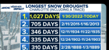
Oh goodness that December I remember well.
Sent from my iPhone using Tapatalk
Flurries as far south as Cocoa Beach.I guess that means it will snow in Florida ? I’m pretty sure Florida got snow in December 89.
Really hope the pacific energy doesn’t disrupt the Siberian express.I like how the trough tries to escape east here on the EPS, and the Aleutian Low / western ridge steps in and says not so fast my friend. The Pac Jet extension in early Dec looks to be in a good location, not too weak / not too far extended....and also, pretty far south / equatorward, especially for early winter / December, and not sending a bunch of low pressure into Alaska....looks Moderate El Nino like (2nd image). That could change, but it makes some sense with us going into a modest +AAM regime which is ideal (3rd image).
Day 8-14 Temperature Probabilities from analogs of CPC pattern forecast

NBAcentel
Member
If there’s a trend I’m noticing, it’s a more eastward shifted western ridge, eastward shifted eastern trough, more energy trying to get trapped in around Alaska which sort of flattens the western ridging a bit. It’s not a bad thing given we already struggle with pacific ridge position. Truly hope we can work on that cutoff near Baja California been so long since that has worked out, managed to move a cutoff around Baja eastward into a departing TPV lobe around SE Canada. 


NBAcentel
Member
Spire is probably the best evolution with the Baja cutoff I’ve seen since that EC AI run a while back 

Woah baby that would do it right thereSpire is probably the best evolution with the Baja cutoff I’ve seen since that EC AI run a while back View attachment 154604View attachment 154605
GolfishardIknowit70
Member
That scenario makes sense with energy ejected east with hp to the north eastSpire is probably the best evolution with the Baja cutoff I’ve seen since that EC AI run a while back View attachment 154604View attachment 154605
18z GFS I know it's long range but the main ingredients are on the table. So it's nice to see a signal. Shows the possibilities.

Last edited:
- Joined
- Jan 23, 2021
- Messages
- 4,603
- Reaction score
- 15,199
- Location
- Lebanon Township, Durham County NC
Maybe it’s like baseball. We need to get on base with a bunt single to unleash a hot streak18z GFS I know it's long range but the main ingredients are on the table. So it's nice to see a signal. Shows the possibilities.
View attachment 154606
NBAcentel
Member
If there’s a time period I’m starting to focus on within this pattern for us to score, it’s here. That southern stream wave around Baja cali and TPV in The NE US. certainly can trend the right way real quick. Need that TPV to slide NE cleanly and something to kick that Baja wave or at least get some energy that sheds off of it, perhaps for some overrunning, and in the same process keep the area around the lakes clean for some trailing high pressure. This look imo starting to get my attention for scoring prospects 

BHS1975
Member
We've had a lot of trouble getting those Baja waves to kick out and they just get stuck or shoved to the southwest.