-
Hello, please take a minute to check out our awesome content, contributed by the wonderful members of our community. We hope you'll add your own thoughts and opinions by making a free account!
You are using an out of date browser. It may not display this or other websites correctly.
You should upgrade or use an alternative browser.
You should upgrade or use an alternative browser.
Pattern December Doldrums 2025 🎄 ❄️
- Thread starter SD
- Start date
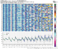
So, the GEFS/EPS agree on the longest winter phase 8 in 50 years that starts on Wednesday. These (13+ days) are even longer than the very long/very cold ones of Feb of 2010, Dec of 1989, and Jan of 1985. The very cold was concurrent with the phase 8. Does that mean it has to also be very cold in the 1st half of this month? No, it’s not that simple as we know.
You are preaching the truth. Going back to late July, its been endless head fakes from all. Showing mega heat/ death ridge 10 days out and flipping on a dime as time marched on. We continue to see this. This weeks wx was being advertised 60's for highs 9-10 days ago. So I will be shocked if models sniff out a winter storm more than 5-6 days out max this year. For the reason mentioned above and mainly when you have the NS driving the pattern, they struggle to identify, time and latch on the the energy coming down properly. Friday event/ non event is a perfect case in point.Models have been awful in the midrange this season. Even the Ensembles have been jumpy.
The models have been struggling a lot in that range. Remember a couple weeks ago we were supposed to be in a full on torch right now. Instead the forecast for my area is below average the whole weekWell that can’t happen with phase 8 can it? If not then I guess the models are wrong or we aren’t really getting to phase 8.
Each year I always feel like December 1 is the true opening to the window for winter threats. We made it gang let’s have some fun! Good luck!! 

LukeBarrette
im north of 90% of people on here so yeah
Meteorology Student
Member
2024 Supporter
2017-2023 Supporter
We need a strong +PNA…
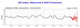
Change of GEFS AO/NAO forecasts just in last 3 days shows how clueless they can be: is it in this case related to the 11/28/25 major SSW?? I’m asking because similar cluelessness was still the case on the day of the 2/16/23 SSWE:
1. AO
Just 3 days ago (day of SSWE): ~+1 for 2nd wk of Dec
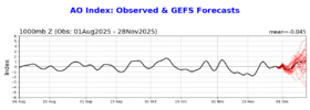
Today: ~-1 for 2nd wk of Dec!
—————
2. NAO
Just 3 days ago (day of SSWE): slight +NAO 2nd wk of Dec
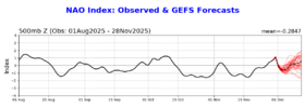
Today: slight -NAO 2nd wk of Dec
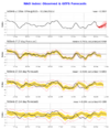
1. AO
Just 3 days ago (day of SSWE): ~+1 for 2nd wk of Dec

Today: ~-1 for 2nd wk of Dec!

—————
2. NAO
Just 3 days ago (day of SSWE): slight +NAO 2nd wk of Dec

Today: slight -NAO 2nd wk of Dec

We need to warm up Alaska. We got to get these troughs to dig.We need a strong +PNA…
Brent
Member
We need to warm up Alaska. We got to get these troughs to dig.
Exactly. Even this little thing out here today is nothing like what the models had a few days ago. Barely any moisture
Shaggy
Member
Tough forecast coming up for Friday temp wise. Euro was a strong wedge with highs in the 30s for most NC and parts of SC and my local NWS has my high at 57. Gonna be Interesting day weather wise to see who is gonna be right
CNCsnwfan1210
Member
We need to warm up Alaska. We got to get these troughs to dig.
Sometimes in a pattern like this disturbances can get a shove south with the polar vortex further downstream with a well timed trough lobe imo
Sent from my iPhone using Tapatalk
Yeah that why I’m not so sure that a strong +PNA is what we want here because the trend on the models closer to verification is for that PV to strengthen and push south. If you add a strong +PNA to that, you run the risk of every piece of energy to get crushed.Sometimes in a pattern like this disturbances can get a shove south with the polar vortex further downstream with a well timed trough lobe imo
Sent from my iPhone using Tapatalk
- Joined
- Jan 23, 2021
- Messages
- 4,602
- Reaction score
- 15,197
- Location
- Lebanon Township, Durham County NC
Thats how new orleans gets another 10" of snow. No thanks.Yeah that why I’m not so sure that a strong +PNA is what we want here because the trend on the models closer to verification is for that PV to strengthen and push south. If you add a strong +PNA to that, you run the risk of every piece of energy to get crushed.
Bigedd09
Member
Yeah looks like we completely lost Friday's system. Oh well
Webberweather53
Meteorologist
CNCsnwfan1210
Member
12z GFS looks like a clipper factory
Sent from my iPhone using Tapatalk
Sent from my iPhone using Tapatalk
Northern Stream will be rocking for the foreseeable future.12z GFS looks like a clipper factory
Sent from my iPhone using Tapatalk
SnowNiner
Member
We need to warm up Alaska. We got to get these troughs to dig.
I'm also hoping the trough over Alaska goes away, and the models are wrong not seeing the mjo phase 8 (operation thaw Alaska). Mid Dec doesn't look great to me right now verbatim (seasonal sure, but not for winter threats IMO). We have a trough in the east (over us), but the trough over AK I think mutes our cold and creates a flow off of the northern pacific instead of from the pole. It's not really cold. I think the cool modeling is really from residual -NAO pushing the PV south. Aleutian Ridge/AK trough is not the combo we want IMO for cold down our way.
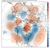
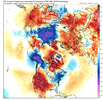
that was a very vaguely interesting look on the 12z gfs at day 7
CNCsnwfan1210
Member


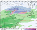
GFS and Canadian do have a system off the coast next Monday will cold enough air close by…7 days out but something to watch, want to see the Euro’s idea on this.
Sent from my iPhone using Tapatalk
Some dots connect at day 10 also.that was a very vaguely interesting look on the 12z gfs at day 7
I want the dots to explode not just connect.Some dots connect at day 10 also.
I’ll alert corncob Cornelius in AlabamaI want the dots to explode not just connect.
- Joined
- Jan 2, 2017
- Messages
- 1,566
- Reaction score
- 4,279
I was actually referring to mid december..the 14th-17th time frame which i know you cant put stock in to but good agreement of a warm upYeh I guess people talking torch are looking at operational runs
CNCsnwfan1210
Member

You can see how the Euro and GFS have changed their tune about the NAO over the past several model cycles trending negative.
Sent from my iPhone using Tapatalk
CltNative90
Member
I don’t think we should be pulling for any dots to explode at this range, unless we are looking for pain and heartbreak.
I’m looking back at the 12z runs from last Monday and it’s insane how far off they were (especially the GFS) with the upper Midwest system this past weekend (only 5-6 days out). A lot of moving pieces out there and if this chaos continues as we get into a more favorable background state, I would expect any threats to look completely different in the medium range than what becomes reality. Pattern needs to materialize on the ensembles before we should start looking for real threats on the operational models, and as we are seeing this week, even the pattern might not be realized more than a week out.
All that being said, I’m optimistic for fun times and surprises ahead!
Haha I wonder why cough phase 8 cough
You can see how the Euro and GFS have changed their tune about the NAO over the past several model cycles trending negative.
Sent from my iPhone using Tapatalk
Most winter storm chances are when the patterns are changing anyway.
iGRXY
Member
Just my 2 cents, until you start getting closer to Phase 8 it's going to be a very big jump fest run to run for operational and ensembles. The other thing is just based on how the LR continues to be flat out wrong and it's taking several cycles into the medium range just to even start to get the pattern correct, I think people need to temper their expectations on a long duration track for any potential winter storm. IMO, we won't really know of any legit threat even showing up until day 4-6 right now.
CNCsnwfan1210
Member
Start the thread.
View attachment 177614
Certainly a different look than the 00z from this morning, and a tad colder perhaps?
Sent from my iPhone using Tapatalk
last year the dominant trend was storms getting squashed/losing neg tilt in the medium range. if that's the case this year then this feature is not something to worry about.that was a very vaguely interesting look on the 12z gfs at day 7
anybody know if any models got updated/upgraded/tweaked since last winter that would reduce/introduce any new biases?
EmilyWx
Member
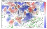
I'm simply not a big fan of the troughing projected by ensembles(EPS and GEFS particularly) near Alaska. Please correct me if I'm wrong but this is a scenario in which yes there would be cold air but it would struggle to be a quality cold air source and one that consistently fleets quickly due to lack of established blocking upstream near Greenland and limited support for established 50/50 lows. Northern stream kinda squashes everything which would favor weak positively tilted troughing over the eastern CONUS and with limited confluence(from our SS) and heights ahead of any trough potentially only leading to weak low pressure systems over our area(this being said will gladly take the much needed rain). The frequent shortwaves/clippers from the NS could still lead to some snow especially for the mountains but it doesn't necessarily favor areas outside of climatological norm for early December. It's a tough look for the southeast right now but once the phase 8 MJO fully sets in(from what I've heard the lag usually takes roughly 5-10 days but that may be incorrect) we should be set up beautifully beginning 2nd week of December. 
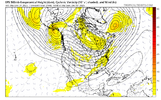


Hence “very vaguely”last year the dominant trend was storms getting squashed/losing neg tilt in the medium range. if that's the case this year then this feature is not something to worry about.
anybody know if any models got updated/upgraded/tweaked since last winter that would reduce/introduce any new biases?
The only “model tweak” i know of is the gfs sucking worse than Tar Heel football this fall
Pattern isn't terrible coming up its just not one that knocks my socks off. I wouldn't be shocked if we tried to sneak something in likely either a late blooming coastal or some weird overrunning messy thing. I also wouldn't be surprised to see a breakdown about week 2 into week 3. That said a breakdown probably gets replaced by a similar pattern potentially colder right around christmas.


