• Hello, please take a minute to check out our awesome content, contributed by the wonderful members of our community. We hope you'll add your own thoughts and opinions by making a free account!

Pattern December Doldrums 2025 🎄 ❄️

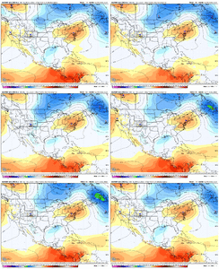
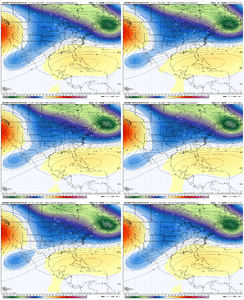
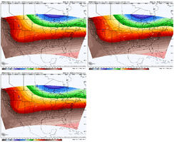
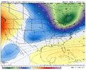
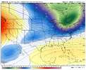
On the AIFS ens/EPS, the SE Canada vortex is trending stronger/slower and more backed up, and the height field is collapsing which is cooling mid levels, imo if we trend colder we need to truly watch that secondary digging energy behind with the second bout of overrunning, because if it digs more in tandem with a stronger cold feed, there could be a ZR problem, esp in the triad IMG_0225.gifIMG_0226.gifIMG_0227.gif
 
On the AIFS ens/EPS, the SE Canada vortex is trending stronger/slower and more backed up, and the height field is collapsing which is cooling mid levels, imo if we trend colder we need to truly watch that secondary digging energy behind with the second bout of overrunning, because if it digs more in tandem with a stronger cold feed, there could be a ZR problem, esp in the triad View attachment 177657View attachment 177659View attachment 177658
Good stuff Fro. Reel it in overnight.
 
On the AIFS ens/EPS, the SE Canada vortex is trending stronger/slower and more backed up, and the height field is collapsing which is cooling mid levels, imo if we trend colder we need to truly watch that secondary digging energy behind with the second bout of overrunning, because if it digs more in tandem with a stronger cold feed, there could be a ZR problem, esp in the triad View attachment 177657View attachment 177659View attachment 177658
yeehhhh i was bout to say be careful rooting for too much of this unless you like ice. nice trends for thu night into fri morning tho
 
A 1030 mb high pressure in that position will get the job done as far as cold air feed. If the Euro is on to something, I think the issue will be whether the precipitation will fall across Virginia and North Carolina as snow or ice and where this will happen. Looking at this model run it looks like a mostly snow event for mountain areas of North Carolina and a possible ice storm from the Foothills to I-95. Ice accrual totals look to be light for now but if lower temperatures keep showing on future model runs and more QPF is introduced to the cold air in place this could end up being a significant event for Virginia, Western and Central North Carolina.
 
A 1030 mb high pressure in that position will get the job done as far as cold air feed. If the Euro is on to something, I think the issue will be whether the precipitation will fall across Virginia and North Carolina as snow or ice and where this will happen. Looking at this model run it looks like a mostly snow event for mountain areas of North Carolina and a possible ice storm from the Foothills to I-95. Ice accrual totals look to be light for now but if lower temperatures keep showing on future model runs and more QPF is introduced to the cold air in place this could end up being a significant event for Virginia, Western and Central North Carolina.
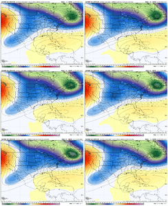
If you look at the soundings, it’s actually supportive of snow for most of the event all the way to highway 1 corridor NC and the northern tier of counties in SC east to highway 1. Of course this if the EURO is on to something. There does seem to be some support the AI and EPS
 
Sorry, catching up on today's runs. So the Euro has a winter storm here two runs in a row after the GFS had been showing it first. Seems like a bizarro world. But it is the Euro and it is inside 5 days.
 
The EURO did have it before the GFS for a couple model runs over the weekend and lost it when the GFS picked it up
Really? I didn't know the Euro had it first. That's actually a good sign. Usually if the Euro shows it that far out and loses it, and another picks it up and then the Euro does again as we get closer it turns into a legit threat. Seen it happen time and time again in the past.
 
Sorry, catching up on today's runs. So the Euro has a winter storm here two runs in a row after the GFS had been showing it first. Seems like a bizarro world. But it is the Euro and it is inside 5 days.

Not sure I would classify it as a winter storm, more like a nuisance type event and that's being optimistic.
 
Already at the range where you can tell if a system is gonna be better or not on the HRRR lol.
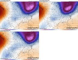
Definitely way better vs the 12z HRRR with the trough sunken further south/cold sunken further south, this translates east ahead of the system. Take with a grain of salt though as it is the HRRR at HR 48>42, not the very best IMG_0229.gifIMG_0230.gif
 
Not sure I would classify it as a winter storm, more like a nuisance type event and that's being optimistic.
Yeah, the QPF is rather measly, and even at the current temps the EC has, rather marginal, I think if this was to become a “winter storm” it would be from ZR with the second wave of overrunning precipitation if things do get colder
 
.2 inches of liquid would be enough to provide the biggest snow in several years for a lot of us, if the temps cooperate. I’m mostly concerned with surface temps where I’m at because the surface air isn’t particularly dry before precip arrives and I hate having to wait on a wedge to deliver the cold after the event has started.
 
I think the issue all along in this setup is that if you flex the wave a bit stronger, it becomes warmer. That's fine, but it's going to be challenging to get both decent precipitation AND keep it cold. But it's definitely worth watching, especially in the more northern areas of course.
1764650487528.jpeg

Yes... to Grit you listen. If in the upstate you live, only pain will you find.
 
Back
Top