NBAcentel
Member
Really gonna be a rate dependent look right there, gonna need heavy precipitation to cool the surface, light stuff won’t cut it more then likely
Really gonna be a rate dependent look right there, gonna need heavy precipitation to cool the surface, light stuff won’t cut it more then likely
I can testify. Winter wonderland up here todayI mean no it didn’t happen in NC but it wasn’t a bust in VA
Sent from my iPhone using Tapatalk
I would say it was a bust for parts of southern Virginia in some regards. But areas closer to central Virginia did just fineI can testify. Winter wonderland up here today
Lets shift this one south for the boys
Lets shift this one south for the boys
Looks like 85 in VA on up to Richmond.I know that road.
View attachment 178103
I don't disagree at all, but there will be a lot of cold bottled up over the next few weeks, just need one well timed wave for y'all.You know you're getting Monday, don't be throwin marginal NC storms at us. Give us the cold ones. lol.
I'm very happy that we keep defaulting back to cool/cold in the medium range, very nice to have a cool below average December which it looks like is in store for us. I just feel for an actual storm, we're waiting for the pacific and the jet to reshuffle a bit to give us a cleaner taller +PNA ridge that will give the SE a better/more southernly cold trajectory and let our northern stream shortwaves tilt a bit. Right now I feel we're not quite cold enough, and not quite troughy enough to get a storm. Good to be in the game, but I'd love to be VA and Mid-Atlantic the next few weeks.
Bingo!Looks like 85 in VA on up to Richmond.
It isLooks like 85 in VA on up to Richmond.


Google weathernext2 is pretty euro-y, maybe a little beefier
Google weathernext2 is pretty euro-y, maybe a little beefier
Google's AI weather model.Excuse me asking but what is that?
Sent from my iPhone using Tapatalk
1989-90 comes to mind here and I'm hoping for the flip. December was an icebox and then winter was gone.A few more pictures from last night. Icy sidewalk! Temps have literally been stuck between 30-38 this whole week. Highs are Pretty impressive for the first week of December. I do worry with how much cold we are getting that it then flips in January during our best snow month.


Sent from my iPhone using Tapatalk
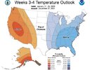
CPC with the buzzkill of the century.. I mean what in the world dude.
View attachment 178104
CPC has had some wins. I’m not one to diss on them like everyone else. I personally enjoy their outlooks. They nailed this one issued on the 27th of December for what came this past January… but man. I just don’t see what they are seeing. Who knows. Just seems like Corncob Cornelius got lazy & just said let’s just go straight La Niña & clocked out for the day.Not surprising considering this is close to the Euro Weeklies, which hopefully are too warm. We’ll see!

I can testify. Winter wonderland up here today
We have cold air, disturbances and a positive MJO phase to work with but as you said, we need a taller +PNA ridge to work with. The upper air pattern that drives our weather needs to have that dip in the roller coaster to bring that colder air further down south and the ascent after the dip just off of the Southeast coast to give us a good old fashioned coastal low to work with. If that +PNA ridge would cooperate then many of us would be in for some fun times ahead.You know you're getting Monday, don't be throwin marginal NC storms at us. Give us the cold ones. lol.
I'm very happy that we keep defaulting back to cool/cold in the medium range, very nice to have a cool below average December which it looks like is in store for us. I just feel for an actual storm, we're waiting for the pacific and the jet to reshuffle a bit to give us a cleaner taller +PNA ridge that will give the SE a better/more southernly cold trajectory and let our northern stream shortwaves tilt a bit. Right now I feel we're not quite cold enough, and not quite troughy enough to get a storm. Good to be in the game, but I'd love to be VA and Mid-Atlantic the next few weeks.
I honestly believe it's programmed into them, because it shows the same thing 95%of the time for weeks 3 and 4. They can't help themselves. They got hot heads. lolCPC with the buzzkill of the century.. I mean what in the world dude.
View attachment 178104
It’s an easy out to just go with warm 90 percent of the time.CPC with the buzzkill of the century.. I mean what in the world dude.
View attachment 178104


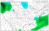
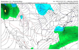
What's the link to this man? I tried to search it yesterday when Evan posted it but I believe i was on the wrong site.yesterday 6z wxnxt vs today 12z. obv the pretty ptype map looks more fun, but the real thing to watch is that H5 trough dug in a little better and the broad coastal sfc low has backed up closer to the SE coast. its a better look on this versus the AIFS. please note these are coarse, 6-hr estimated ptype average maps and really should only be used for QPF ideas and syntopic feature placement
View attachment 178108
View attachment 178109
CPC has had some wins. I’m not one to diss on them like everyone else. I personally enjoy their outlooks. They nailed this one issued on the 27th of December for what came this past January… but man. I just don’t see what they are seeing. Who knows. Just seems like Corncob Cornelius got lazy & just said let’s just go straight La Niña & clocked out for the day. View attachment 178106
That makes sense man. Thanks for the explanation sir.No, Mitch, it wasn’t laziness as I assume they saw the straight extended Euro model guidance that is very similar.
I remember quite clearly the very cold weeks 3-4 outlook that you posted for Jan of 2025 because it was one of the coldest, if not the coldest, in the SE on record since they started issuing them. I was as excited as ever and was posting about how they were the coldest ever. At the time, the Euro Weeklies, had been locked on cold for weeks 3-4. So, it made sense to go cold then. But in total contrast, they’re mild due to a SE ridge. So, it makes about as much sense to go mild now as it did then to go cold.
Promise im not gatekeeping bc I want weather forum likes for myself, but the link is not mine to share. Sorry manWhat's the link to this man? I tried to search it yesterday when Evan posted it but I believe i was on the wrong site.
It's cool.not gatekeeping bc I want weather forum likes for myself, but the link is not mine to share. Sorry man
just curious, what is the link really in the first place? is it secret because the product is licensed or something? no hate at all just curious lol.Promise im not gatekeeping bc I want weather forum likes for myself, but the link is not mine to share. Sorry man
These are really cool graphics. Thanks for sharing.Some AIFS ensembles panels
Mean as a whole for the ptype View attachment 178110
More importantly the confidence level View attachment 178111
Individuals View attachment 178112View attachment 178113
Apologies, I’m currently hosting the maps on my employer’s server, so only our internal team has access atm. I’ll iron out if we’re allowed to make that data public as a private wx company (depends on Google’s terms), or I may just end up hosting on GitHub for y’all to access. I’ll circle back next week.Promise im not gatekeeping bc I want weather forum likes for myself, but the link is not mine to share. Sorry man
Apologies, I’m currently hosting the maps on my employer’s server, so only our internal team has access atm. I’ll iron out if we’re allowed to make that data public as a private wx company (depends on Google’s terms), or I may just end up hosting on GitHub for y’all to access. I’ll circle back next week.
Also hi, first forum post
