CNCsnwfan1210
Member
Going to be one heck of a battle come December. View attachment 176942
Wagons south with that ridge, we’ll take all the good moves we can get.
Sent from my iPhone using Tapatalk
Going to be one heck of a battle come December. View attachment 176942
That 12z euro was brutal with the SE RIDGE

Today’s Euro Weeklies 10 mb 60N zonal wind isn’t as weak as recent runs:
Today’s run (11/19):
View attachment 176895
Yesterday’s (11/18):
View attachment 176896
Does anyone else see what I’m referring to? I’m not just talking about whether it actually reverses. I’m talking more about the period afterward. That’s a notable change in the stronger direction.


OHHHHHHHHHHHHHHHHHHHLAWWWWWWWWWWWWWWWWWWWWWWWDToday’s Euro Weeklies 10 mb zonal wind mean is slightly weaker early and allows most to reverse unlike yesterday. However, afterwards it looks like yesterday’s significantly stronger run:
Today’s
View attachment 176949
Yesterday’s:
View attachment 176950
Two days ago: significantly weaker
View attachment 176951
I guess areas east of the Apps will have to wait until December to get some cooler air !


Thanks goodness this far out we really have no idea.Tough pattern ahead for the southeast


.png")
Wish there could be a knot in phase 8 lol. Looking at this we will have to kick the can till January. Go figureGood ole knot in phase 7.
View attachment 176975
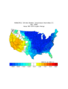
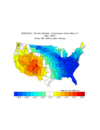
Bad combination. D4 (Exceptional Drought) in Extreme Southern Georgia and no rain in sight !Good combination here! We need the rain! A lot of D1-D2 conditions here as of yesterday! View attachment 176973View attachment 176974


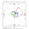
The 6 coldest La Niña to neutral ENSO Decembers in the E US as a whole since 1974 have been 1983, 1985, 1989, 2000, 2005, and 2010:
View attachment 176993
Here are the respective Dec MJOs:
1983: mainly inside COD or just outside/no strong
View attachment 176994
1985: almost all inside COD
View attachment 176995
1989: most of 8/1 just outside COD or inside it/no strong
View attachment 176996
2000:almost all just outside or inside COD
View attachment 176997
2005: all inside COD
View attachment 176998
2010: all just outside or in COD
View attachment 176999
What do these 6 have in common regarding the MJO? No strong and most days just outside to inside COD.
Regarding the extended progs that have the Dec 1-21 MJO: note how strong they are, especially GEFS but even the Euro is solid compared to the six cold Decembers posted. My concern is that the MJO amplitude will be too strong, based on history, to allow for a widespread intense cold dominated E US in Dec. Thus, I’m hoping the progs remain going into 8, but weaken. My hypothesis as to why strong MJO has had a tendency (though not always, of course) to not be as cold as weaker MJO is because the higher amp may tend to bring up too much warmth from the tropics, where the MJO is measured


Starting to smell another good Texarkana snowstorm for them first half of DecemberPresented without comment...
the good news is, the latest AIFS is the most aggressive yet in the LR as far as bleeding cold eastward towards the end of the first of Dec.Presented without comment...

Go on & reel ya one in Eric.Unlike the SE US where you can get CAD, overunning, coastal events, etc. there’s really only one recipe that can give us a good snow event in New Mexico and this longwave pattern isn’t too far off from that in early December.
So many ways to screw this up but I’m at least intrigued.
Regardless, this should be a nice table setter event over the conus to get the cold well established and deeply entrenched
View attachment 177012
Great pattern for youUnlike the SE US where you can get CAD, overunning, coastal events, etc. there’s really only one recipe that can give us a good snow event in New Mexico and this longwave pattern isn’t too far off from that in early December.
So many ways to screw this up but I’m at least intrigued.
Regardless, this should be a nice table setter event over the conus to get the cold well established and deeply entrenched
View attachment 177012
.png")


If this don’t tickle your pickle, you need to find a new hobby! View attachment 177019