Z
Zander98al
Guest
Well 5 days out and we have a severe outlined area over the great state of Alabama and adjacent areas.

Definitely a moist air mass setting up shop around the southeast for a good chunk of time. Models aren't in good agreement that far out though, heck the day 5 risk still isn't in good consensus with models lol. But I imagine with the moist air mass there will be some threat eventually down the road from the first potential batch. January seems to be a bad month for tornadoes in Alabama. Two ef3s just miles from me the last 10 years in January.May want to extend the date.
Unfortunately the euro is more bullish much more . Large warm sector with plenty low level shearThe GFS looks less impressive for the second event around New Years.
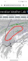
Also a decent EML may be present. The trough picks up a upper level low over the southwestern deserts. Similar to the early December outbreak in the Mississippi valley.Unfortunately the euro is more bullish much more . Large warm sector with plenty low level shear
I think so too. The wensday system though might be a banger. I'm pretty intrigued, looking at forecast soundings. Shows a loaded gun setup. There's a decent bit of supportive factors for wensday, the cape has ticked up with each new NAM run, wouldn't be surprised for a enhanced corridor at least. Might not be a tornado outbreak with the wensday system but it sure could produce 1 or 2 significant storms.Still think the second system around new years has a even higher ceiling
https://southernwx.com/community/threads/new-years-severe-weather-event.1024/ DoneIt might not be a bad idea to create a separate thread for the weekend system to prevent confusion. Especially if things get busy Wednesday

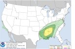
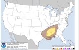
 Latest day 3 outlook
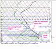
Big boy EML present wensday. View attachment 99319
Looks like a environment where updrafts would struggle a bit given skinny cape and somewhat weaker low level shear, still a environment that can produce thoBig boy EML present wensday. View attachment 99319
I thought good EML aided in better lapse rates though.Meh, those lapse rates kind of suck.
That’s not really a EML but just lots of dry air aloft, a EML typically has 6.5C+ lapse rates, lapse rates under 6C are very poorI thought good EML aided in better lapse rates though.
Hmmph. I thought dry air aloft and eml where the same ?. I always looked at the 500mb area and see those jagged lines pushing to the west of the sounding and thought that correlated with a good EML. Does both no aid in more discreet convection, and loaded gun soundings?That’s not really a EML but just lots of dry air aloft, a EML typically has 6.5C+ lapse rates, lapse rates under 6C are very poor
Typically a EML has steep mid level lapse rates (near dry adiabatic lapse rate) and a cap within a area of dry desert airHmmph. I thought dry air aloft and eml where the same ?. I always looked at the 500mb area and see those jagged lines pushing to the west of the sounding and thought that correlated with a good EML. Does both no aid in more discreet convection, and loaded gun soundings?


It's been very windy here. In birmingham69/66 here at 650 after a Hi here of 76! to be honest it "feels" like severe on the way weather. Only thing missing is the wind is near calm
