• Hello, please take a minute to check out our awesome content, contributed by the wonderful members of our community. We hope you'll add your own thoughts and opinions by making a free account!

Wintry December 28-29th Possible Winter Storm

The 10-12 inches of snow you got is already historic I’d say. I live more north then almost all on this board and it took me 10 years of living in Tennessee to see a storm dump 12 inches imby. Hopefully it’s not another Ten though.
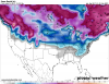
Completely agreee. It was historic for this area. Most I’ve seen in GA since March 93. I think we got more snow this time but the wind and drifts in 93 were unreal. And a blizzard warning is pretty cool.
 
GA, but I really don't see this being a big deal for Bama


Sent from my iPhone using Tapatalk

It's not for nearly 90% of the state usually just the two rows along the GA boarder (along the Apps and points E) that see anything from most of these CAD events I've seen rest of the state in the upper 40's and 50's while this was ongoing
 
Could easily be a big deal for the higher elevations of E AL


Depends on how deep the cold is. It could be a bigger deal for the valleys where he cold air can leach down. Personally if AL gets involved take your finger and trace from whereal the Tallapoosa comes into AL down to Lake Martin. That is your battle area.
 
Jeeze, the Euro control (which is lighter than most members in regards to precip totals) has the 32F line to the SC coast:

jeeze.png
 
From Robert Gamble at wxsouth:
After catching my breath, and regaining conciousness from viewing all the afternoon data and ensembles suite--I'd have to say this looks very ominous. Still 5 to 7 days out though, and subtle shifts could occur--but the least likely shift would be on the low level Arctic Cold temps. With precip falling, temps will be in the lower 20s throughout piedmont Carolinas, mid 20's Atlanta metro during heart of the event, even upper teens for temps in part of Virginia, eastern West Virginia--so snow ratios would be much higher than a typical 10 to 1 Ratio.
Imagine having 1" or more of Liquid Precip fall into air that is 27 degrees? I'm talking to you Georgia and South Carolina.
 
What should we be looking for model-wise that would indicate more IP than ZR?


Sent from my iPhone using Tapatalk
 
Jeeze, the Euro control (which is lighter than most members in regards to precip totals) has the 32F line to the SC coast:

jeeze.png

That freezing line into AL is very concerning, as is the lighter precip. Not only would the lighter precip not pull down the warmer temps above the surface, it also would limit latent heat release from freezing droplets. That also on top of higher ice accrual rates.

All this I'm taking about into AL where temps would be more borderline. Bottom line, nasty setup.
 
The 10-12 inches of snow you got is already historic I’d say. I live more north then almost all on this board and it took me 10 years of living in Tennessee to see a storm dump 12 inches imby. Hopefully it’s not another Ten though.
i got 13 inches of snow in february 2009 big bowling ball ull...
 
Depends on how deep the cold is. It could be a bigger deal for the valleys where he cold air can leach down. Personally if AL gets involved take your finger and trace from whereal the Tallapoosa comes into AL down to Lake Martin. That is your battle area.

Ok I tried to map this out with topography to show how it effects E central AL folks usually. Of course this is dependent oh HP location and strength but most CAD events for this area go like so

EDCD4323-_F77_F-40_DF-_A5_C9-83_BD3_AB81733.jpg
 
Great map.
The blue lines I'm tried to show where it drains and feathers out thru the App's... The brighter is higher elevation of course and usually have no issue icing up...i habe seem it go farther W to about the I-65 corridor but it rarely happens unless it is a massive MB high and placement is farther S
 
Ok I tried to map this out with topography to show how it effects E central AL folks usually. Of course this is dependent oh HP location and strength but most CAD events for this area go like so

EDCD4323-_F77_F-40_DF-_A5_C9-83_BD3_AB81733.jpg
Good map. The nose including Gadsden is fact. Probably parts of Scottsboro and Fort Payne included. Maybe Far East Blount.
 
Good map. The nose including Gadsden is fact. Probably parts of Scottsboro and Fort Payne included. Maybe Far East Blount.
Yes I was little of up on the northern part here is another map you can literally see the drain pattern in the area I outlined a moment ago. Most of the time it is hard to get it back any farther West say towards Blount Eastern Jefferson the cold dense air doesn't want to climb again unless strong HP
C44_C7_EEB-6_ED8-4821-_B5_E4-_AD01187_D9955.jpg
 
Per 12z Euro (not being talked about yet) these wind gusts would be problematic for areas that receive ice:

ecmwf_uv10g_se_25.png

Thanks for posting the wind map. Anytime there is an ice threat for the area north and northeast of Atlanta, I worry about winds.

Our trees have taken a beating the past four months, from Irma and the heavy wet snowfall. That amount of ice on those trees with any type of steady breeze concerns me greatly.

—30—


Sent from my iPhone using Tapatalk
 
You can see the difference at 5H out west with energy 18Z GFS vs NAM
5570b0424d0f50f377de9297a7a6ffc4.jpg
627e5f78f5683125c8084ab5d758b456.jpg


Sent from my SM-N950U using Tapatalk
 
One can see the wedge, really anchored down and the Wintry weather starting to break out per 18z Canadian (at the end of it's run):

I_nw_EST_2017122312_126.png
 
HSV looking at this time frame now: kept with chance POPs Friday/Friday night
where another wintry event is possible. With this being at the tail
end of the forecast package and with persistent model disagreement
will keep accumulations out but need to keep an eye on this event.
 
No worries everyone GFS still out to lunch... storm on GFS will show back up about 36 hours from onset of storm
 
12z Canadian Ensembles are still on board of a significant Winter storm in the Southeast: (some are much further along, and go through the 31st with timing differences):
 

Attachments

  • 1.gif
    1.gif
    940.6 KB · Views: 61
  • 2.gif
    2.gif
    966 KB · Views: 57
  • 3.gif
    3.gif
    939.7 KB · Views: 59
Big step back on the 18z GEFS by looking at the snow depth mean on pivotal. Someone else can fill us in on what’s going on when the individual panels come out.

Edit: my guess is more suppressed solutions like the op. The huge totals for the MA went poof! As Webber said previously, the ensembles will often mirror the op, because there are not enough perturbations programmed into the ensembles. I think.
 
At this point it’s good too see the GFs not showing a thing. Model is so bad you don’t want it showing anything until 2 dads out
 
Big step back on the 18z GEFS by looking at the snow depth mean on pivotal. Someone else can fill us in on what’s going on when the individual panels come out.

You're looking too far in advance. Their maps start to remove accumulation the further you get out from them storm. Here is what it looks like for this event: (these maps try to use an algorithm to remove ice/sleet) but it isn't fool proof.. so its still an icy mess per this:
 

Attachments

  • snod.conus.png
    snod.conus.png
    295.2 KB · Views: 67
Damn lol you'd probably even have some light snow in the midlands at the onset if that verified

That's quite probable with the wedging/AG signature that strong, the SFC FZ line gets that close to the coast. OP EURO pulls KCHS down to 34 at 06z 12-29, before warming back up to 40 during the afternoon. We all know under steady precip and channeled NNE winds don't allow that even down in my world❄
 
Big step back on the 18z GEFS by looking at the snow depth mean on pivotal. Someone else can fill us in on what’s going on when the individual panels come out.
Hope this is appropriate ... but here goes ...
1) It's 18Z
2) The Pac is so screwy models are just spitting out junk (GIGO)
3) Trends are the key (and IMHO, looking back over 5 days, trends are not supporting anything colossal - only seasonal)
 
Back
Top