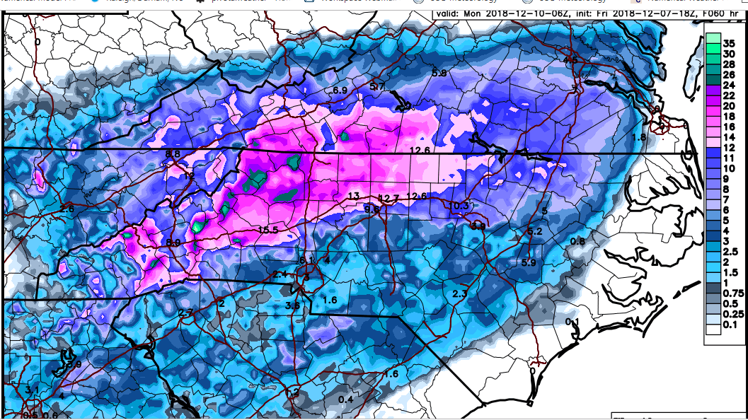
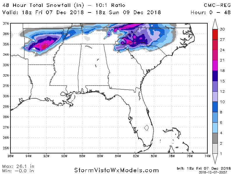
The hrrr has a horrible warm bias with CADs and is normally just a warmer model in general until you get close the event/hour
-
Hello, please take a minute to check out our awesome content, contributed by the wonderful members of our community. We hope you'll add your own thoughts and opinions by making a free account!
You are using an out of date browser. It may not display this or other websites correctly.
You should upgrade or use an alternative browser.
You should upgrade or use an alternative browser.
Wintry Dec 8-10th Winter Storm
- Thread starter SimeonNC
- Start date
Flo
Member
We got it the first 50 times you said it.Looks like around 4 inches of snow with ice on top is a safe bet around my way.
.thumb.png.c091e247523fb1b8be759f6bca0e8d3f.png)
Some of the SREF members (that are heavily based on the NAM parameters for the most part) have been alluding to this mixed mess, even to the North lately.
Charlotte looks like a major forecast headache, tbh.
Charlotte looks like a major forecast headache, tbh.
ice will be limited due to heavy rates...and for locations who manage closer to 28 degrees not 32. Also sleet can cut down totals. I would prepare but widespread heavy icing rarely happens and this setup doesn’t support it in my opinion only thank you hello cold rain
Shawn based off the WRF models which is what the RPM is based off which is a very good model is showing maybe some ice in Central Midlands (Columbia). Do you think it’s possible?Some of the SREF members (that are heavily based on the NAM parameters for the most part) have been alluding to this mixed mess, even to the North lately.
B
Brick Tamland
Guest
Look at that gradient for Wake. And 10.3 for Durham but 3.9 for Raleigh. Looks like it has me in the 6 to 8 range.


Winter Storm Watch not far from the northern ATL suburbs for Lumpkin County !
GSP popping on the WSWarning! 2-6” of snow and sleet. Enough ZR to cause a lot of tree damage and power outages!
Arjen Robben
Member
Longtime lurker . I am wondering does anyone think Georgia( especially metro ATL) is still in play ?
We all know a lot of things can happen run. There was a vast change in the models from Sunday to Wednesday. It went from a board wide winter storm to mainly a WNC,NE GA, and Upstate South Carolina storm.
With 48-72 hours left to the storm is there a legitimate chance that accumulating snow could occur in places to the south like metro Atlanta for instance ?
The Temps in the cold rain, ZR and sleet areas are borderline.
Something like this has happened before. I remember January 2014 the models only picked up on a wintry event for mby 2 days before .
B
Brick Tamland
Guest
Under a Winter Storm Watch now.
Shawn based off the WRF models which is what the RPM is based off which is a very good model is showing maybe some ice in Central Midlands (Columbia). Do you think it’s possible?
THE RPM model is based off an extremely customized WRF-ARW by WSI Inc. They run a lot of the local news systems and own the Weather Channel. It's a hit or miss model, basically.
It's used a lot in our "Futurecast" products if not the HRRR.
B
Brick Tamland
Guest
.WINTER STORM WATCH REMAINS IN EFFECT FROM LATE SATURDAY NIGHT
THROUGH MONDAY EVENING...
* WHAT...SIGNIFICANT ACCUMULATIONS OF SNOW, SLEET AND FREEZING
RAIN ARE POSSIBLE. TOTAL SNOW AND SLEET ACCUMULATIONS OF 3 TO 6
INCHES ARE POSSIBLE, WITH THE GREATEST AMOUNTS TO THE NORTHWEST
OF OXFORD, DURHAM, PITTSBORO AND TROY. IN ADDITION, FREEZING
RAIN ACCUMULATIONS OF AROUND, TO A LITTLE MORE THAN A TENTH OF
AN INCH, ARE POSSIBLE.
* WHERE...THE NORTHERN, EASTERN AND SOUTHERN PIEDMONT INCLUDING
THE WESTERN PORTIONS OF THE TRIANGLE.
* WHEN...LATE SATURDAY NIGHT THROUGH MONDAY EVENING.
* ADDITIONAL DETAILS...TRAVEL IS LIKELY TO BE VERY DIFFICULT
SUNDAY INTO MONDAY. EVEN IN LOCATIONS WITH LESSER SNOW
ACCUMULATIONS, THE POTENTIAL FOR ACCUMULATIONS OF SLEET AND
FREEZING RAIN WILL IMPACT TRAVEL.
PRECAUTIONARY/PREPAREDNESS ACTIONS...
A WINTER STORM WATCH MEANS THERE IS POTENTIAL FOR SIGNIFICANT
SNOW, SLEET OR ICE ACCUMULATIONS THAT MAY IMPACT TRAVEL. CONTINUE
TO MONITOR THE LATEST FORECASTS.
THE LATEST ROAD CONDITIONS FOR NORTH CAROLINA CAN BE FOUND ONLINE
AT DRIVENC.GOV.
Arjen Robben
Member
There is a sharp gradient in North vs South Fulton county in Georgia. 3 inches in North Fulton to half an inch 20 miles southLook at that gradient for Wake. And 10.3 for Durham but 3.9 for Raleigh. Looks like it has me in the 6 to 8 range.

B
Brick Tamland
Guest
snowlover91
Member
The ICON came in significantly colder.

Yess much colder.The ICON came in significantly colder.

This guy on Fox Carolinas!! What a bafoon! Jimmy don’t watch! He has us in flakes/to a trace on his map!could be right, but I mean does he not see the WSW!?
ATLwxfan
Member
Longtime lurker . I am wondering does anyone think Georgia( especially metro ATL) is still in play ?
We all know a lot of things can happen run. There was a vast change in the models from Sunday to Wednesday. It went from a board wide winter storm to mainly a WNC,NE GA, and Upstate South Carolina storm.
With 48-72 hours left to the storm is there a legitimate chance that accumulating snow could occur in places to the south like metro Atlanta for instance ?
The Temps in the cold rain, ZR and sleet areas are borderline.
Something like this has happened before. I remember January 2014 the models only picked up on a wintry event for mby 2 days before .
None of the models save the WRF really support anything frozen ITP. I’d say if you’re up in Cumming or Gainesville, ZR is a real possibility. Otherwise, you would be lucky to catch a flake mixing in. The problem is two-fold. No good arctic airmass and dwindling precip rates with the ULL.
Sent from my iPhone using Tapatalk
Avalanche
Member
Dang, Pittsboro/Chapel Hill with 10-12. What I would give for that to verify!!!
Jessy89
Member
He’s ignoring it. I know Chris justice is calling for 1-4 inches mostly sleetThis guy on Fox Carolinas!! What a bafoon! Jimmy don’t watch! He has us in flakes/to a trace on his map!could be right, but I mean does he not see the WSW!?

