WXinCanton
Member
It was an impressive front end snow then flip to ice. Says freezing rain but would be great if it was sleet.Wow, NAM is doubling down, globals are being consistent for a big storm, too. The potential is there for this to be an incredible storm
So very little snow for upstate mostly Freezing rain and sleet

Definitely Monday is the best day for GA.Flizzard IMBY!!!!
Any accumulationNAM has a flizzard for the ATL area.
Yeah, we should hope it is colder and more snow or less precip here, because that much ice and snow mixed is dangerous.Wow this is a weenie run. 42" of snow in the Northern NC Mountains. 12"' of sleet from SW mountains through Charlotte to Gboro, and 1-3" of ice from GA through Charlotte through Raleigh. NC Destroyed by all possible precip types
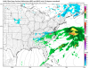
Has to be overdone though, because it's showing a widespread 3-6" of QPFView attachment 8733 View attachment 8734 View attachment 8735
Looks like a big sleet storm in Charlotte to me
Most of that is zr for our area. I still think it'll be a cold rain. I'm guessing temps will hang right around 32 or 33 degrees so low impact. Of course I hope I'm wrong.Wow, NAM is doubling down, globals are being consistent for a big storm, too. The potential is there for this to be an incredible storm
Most of that is zr for our area. I still think it'll be a cold rain. I'm guessing temps will hang right around 32 or 33 degrees so low impact. Of course I hope I'm wrong.
Any accumulation