Jessy89
Member
Oh sorry read that wrongNot sat morning no. Sunday morning yes
Sent from my SM-G955U using Tapatalk
Oh sorry read that wrongNot sat morning no. Sunday morning yes
Sent from my SM-G955U using Tapatalk
If FFC is on to something, it looks like the adjacent NWS offices aren't seeing it yet...

No.Does any modeling even support this widespread ZR?
Sent from my iPhone using Tapatalk
My God I would hate to be in Charlotte. Talk about threading the needle !
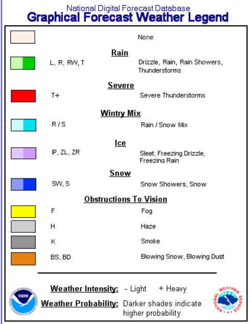
Here's the color key:So according to that map, the light and dark purple are both ice. Does the darker shaded purple indicate heavier freezing rain ? I guess according to this map West GA is going to see some heavy freezing rain.

Yeah basically the way Tidbits determines what p-type is falling is pretty flawed and doesn't look at the entire column. So if an area is 33-34 at the surface and 850s are fairly close to 0C but above it it will show that as "snow" on the accumulation map even though it would be rain or at best sleet falling.
Not quite, DGZ is very dry. Probably mostly sleet.
Darker shades indicate higher probability. So according to them, West GA has a higher probability of seeing Freezing Rain than NE GA. Ok then........Here's the color key:

Until it is nothing, other than a rain sleet mix.Wow, that would be something.
Yep, Rain mixed with the occasional pinger. Folks are trying to read too much into it.They particularly state IP in that Georgia Graph so I assume they expect due to temps majority of Mix will be in the form of Sleet
You'd think so, but BMX isn't seeing it that way - just plain ol' rain in eastern AL according to them.Darker shades indicate higher probability. So according to them, West GA has a higher probability of seeing Freezing Rain than NE GA. Ok then........
This map shows Pickens County getting 6 inches. Downtown Greenville less then 2 inches...My God I would hate to be in Charlotte. Talk about threading the needle !


2 inches is plenty for the kids to enjoyThis map shows Pickens County getting 6 inches. Downtown Greenville less then 2 inches...
