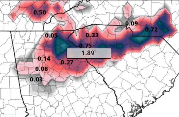
https://www.weather.gov/media/gsp/YouTube/brief.pdf this is the link to their briefing and that lr snow map
-
Hello, please take a minute to check out our awesome content, contributed by the wonderful members of our community. We hope you'll add your own thoughts and opinions by making a free account!
You are using an out of date browser. It may not display this or other websites correctly.
You should upgrade or use an alternative browser.
You should upgrade or use an alternative browser.
Wintry Dec 8-10th Winter Storm
- Thread starter SimeonNC
- Start date
MichaelJ
Member
GEFS and GFS are still stuck so no maps available right now. Since we are waiting for them, go to a post I just put up on the winter 18-19 thread. Those who miss out on this one will be pleased
Jessy89
Member
When one you like? 18z Euro v/s GFS. GFS a little quicker bringing in precip which is big difference for us central NC folks.
View attachment 8548 View attachment 8549
You notice gfs favors ne upstate. While euro favors nw upstate
How did the 18z Euro look someone??? Stronger ridge I hope.
Sandstorm94
Member
There is increased uncertainty Monday and Monday night. Low-level
cooling may occur on the backside of the low as it shifts farther
northeast. The models indicate wrap-around moisture but have not
been consistent with the moisture depth and the development and
placement of the cold upper system. Updated to change precip
type to snow showers in the evening...best chance remains to the
north. At least flurries in the south Midlands/CSRA as upper
trough moves over the area. Moisture becomes more shallow after
06z.
Still in the game!
NoSnowATL
Member
Late to the party but DAMN! Sorry for the language.
I compared the Dupage ptype maps with the weathernerds ptype maps and they are very very different to the South for the core of the event. When I click the area around CAE to generate a sounding on dupage, it gives me temps in the 40s and rain. When I do the same with the weathernerds website, it gives me some coordinates that when reversed show southern SC and says 32.8F and a mix.
Something is not right. Be very careful with the tidbits & weathernerds ptype/accumulation maps.
Something is not right. Be very careful with the tidbits & weathernerds ptype/accumulation maps.
B
Brick Tamland
Guest
Love how it jumps from 2.8 to 15.9.Here’s a better FV3 map that filters out the ice. Still a huge hit.
View attachment 8540
Lol FV3 has a little finger of foot plus over me now..... rightHere’s a better FV3 map that filters out the ice. Still a huge hit.
View attachment 8540
Sent from my SM-G950U using Tapatalk
FYI...a bunch of NCEP products are currently not working
"NCO Has noted that we have a backlog of data due to system problems.. Data below will be delayed.. DataFlow is currently working to distribute this data.. gfs18 - gfs22 - hourly22 - hrrr21 - lmp22 - pcpanl21 - prod/etss22 - prod/gfsmos18 - prod/gtg21 - prod/gtg22 - rap21 - rap22 - urma2p516 - wave18 - Thankyou for your patience.."
"NCO Has noted that we have a backlog of data due to system problems.. Data below will be delayed.. DataFlow is currently working to distribute this data.. gfs18 - gfs22 - hourly22 - hrrr21 - lmp22 - pcpanl21 - prod/etss22 - prod/gfsmos18 - prod/gtg21 - prod/gtg22 - rap21 - rap22 - urma2p516 - wave18 - Thankyou for your patience.."
Yellow Snow
Member
The Pivotal FV3 map gives nearly 2" of ice to Banks County - that'd be simply horrific.I ain't gonna lie, that run of the FV3 has me a little worried about ice if we keep going trends wise, although the TT maps are obviously clownish and wrong.

The Unknown
Member
I was gonna ask the same thingHow did the 18z Euro look someone??? Stronger ridge I hope.
W
WeatherLC
Guest
There is no 18z euro. Just 0z and 12z. Eps is another story thoughHow did the 18z Euro look someone??? Stronger ridge I hope.
Kuchera doesn't really filter out the ice. It just uses the max temp of the column to determine the snowfall ratio (which isn't even necessarily accurate) based off of the liquid equivalent that has fallen. So it still includes IP because model snowfall is SN+IPHere’s a better FV3 map that filters out the ice. Still a huge hit.
View attachment 8540
Ethan
Member
What did the 18z EPS say?
Kylo
Member
There is no 18z euro. Just 0z and 12z. Eps is another story though
There's an 18z Op Euro, only rolls out to 90. I posted the snowmap above. Very similar to the 12z.
packfan98
Moderator
The 18z GEFS is running on pivotal.
I see you FV3 lol. Here pivotal's ice accumulations.
Soundings have wintry mix sleet/zr Sunday afternoon/evening then transition to snow Monday.View attachment 8541 View attachment 8543 View attachment 8545
Just quoting this to make a point for those in AL and GA. Just because 850s may drop below 0C it doesnt mean snow. On the two soundings above, it wouldnt be snow even if it was slightly colder through the column. The DGZ is dry, so at best it would be sleet/graupel. Watch out for that if the models start showing snow for these areas.
Kylo
Member
What did the 18z EPS say?
Another 45 mins until done.

