Going back and forth with snow and sleet. Power starting to flicker, on the Durham/Orange county line.
-
Hello, please take a minute to check out our awesome content, contributed by the wonderful members of our community. We hope you'll add your own thoughts and opinions by making a free account!
You are using an out of date browser. It may not display this or other websites correctly.
You should upgrade or use an alternative browser.
You should upgrade or use an alternative browser.
Observations Dec 8-10 Obs & Pictures Thread
- Thread starter EV/WS
- Start date
MichaelJ
Member
Just after I posted the previous post (and I mean JUST after) Lost a 30-40' tree in my backyard 
WCDawson
Member
We were oh so close. Stayed between 33.8 and 33.3 for most of the night with a rain/sleet mix in Dahlonega. The sleet is just now finishing melting off my deck. There was enough accumulation for the dog to go sliding through it first thing this morning when he went out.I was expecting to see a lot of ice storm pics in GA and havent seen any yet.....
Still a fun storm. Haven’t seen the wind blown snow like that in many years. Sure beats a rain storm
No snow for you
Member
- Joined
- Dec 28, 2016
- Messages
- 583
- Reaction score
- 890
Do you have power? Ours is out on the Cleveland road side of Augusta. I think a transformer went.I think the freeze line ran *just* south of I85 overnight - had crazy amounts of sleet overnight with a low of only 32 (at my location never went lower than 32.0) - this system with a *little* lower temps would have been historic for GA/SC
GeorgiaGirl
Member
This cam may be even crazier late this morning:
http://www.resortcams.com/webcams/jefferson-landing/
Heavy and blowing snow.
http://www.resortcams.com/webcams/jefferson-landing/
Heavy and blowing snow.
Yellow Snow
Member
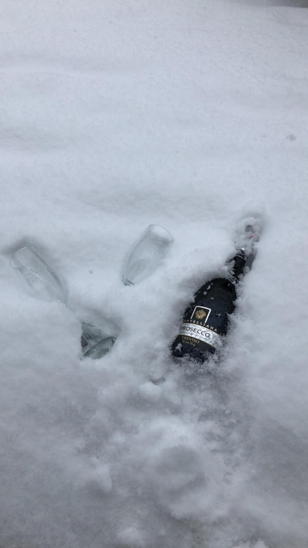
A friend of mine up near Lynchburg VA posted this on her Facebook a few minutes ago - really is the best way to chill champagne for mimosas...
drfranklin
Member
- Joined
- Dec 1, 2016
- Messages
- 511
- Reaction score
- 760
power out in parts of our neighborhood (off Parkins Mill Road) - but, thankfully, we have powerDo you have power? Ours is out on the Cleveland road side of Augusta. I think a transformer went.
I measured 2 inches in the hood of my car this morning. Not bad considering we are nickel and dimers to begin with. I have a feeling we will break our 6”+ losing streak this year
Approximately 7-7.5" of snow.
I thought some of that was sleet.
11" in northern Guilford County, NC. Breifly went to sleet during the past hour, but back to heavy snow now
Hard to have a good ice storm at 35 degrees?!!! School already called for tomorrow! I think it’ll be closed through Wednesday, IMO! Nice 5 day vacay for them!I was expecting to see a lot of ice storm pics in GA and havent seen any yet.....
78000 people without power in Greenville county alone!!
NWCummingWx
Member
I've been at work all day but goes without saying that the freezing line in N GA didn't get as far west and south as I thought. My low was just 33.2. Not the biggest letdown granted I was only thinking a light glaze here but to not really even come close, (I thought I'd at least drop to freezing kinda shocked me). I suppose in the future, we need to realize here in the NE Metro area that if the temps/dp's aren't low enough upstream in the Carolinas to wedge in, then it ain't happenin' for us. Lesson learned I suppose, but still sucks.
Emory Briarcliff
Member
Pretty snow up at Walasi-Yi at Neels Gap in the Georgia mountains.
More scenic snow at the Len Foote Hike Inn in the Georgia mountains.
MichaelJ
Member
Pretty snow up at Walasi-Yi at Neels Gap in the Georgia mountains.
More scenic snow at the Len Foote Hike Inn in the Georgia mountains.
Question for you Emory, how tall are the mountains in N Ga?
ForsythSnow
Moderator
Precip building back in west GA. Temps look great throughout the column. Only thing is the DGZ is dry. Maybe sleet?
Emory Briarcliff
Member
The highest point, Brasstown Bald, is 4,784 feet above sea level. Neels Gap where Walasi-Yi is located is near Blood Mountain which is 4,458 ft and is the sixth tallest peak in Georgia, just to give you some idea. Georgia especially in the NE corner has some decent elevation but still less than North Carolina or Tennessee. Blood Mountain by the way averages about 35 inches a year in snowfall.Question for you Emory, how tall are the mountains in N Ga?
MichaelJ
Member
Wow, good info, thank youThe highest point, Brasstown Bald, is 4,784 feet above sea level. Neels Gap where Walasi-Yi is located is near Blood Mountain which is 4,458 ft and is the sixth tallest peak in Georgia, just to give you some idea. Georgia especially in the NE corner has some decent elevation but still less than North Carolina or Tennessee. Blood Mountain by the way averages about 35 inches a year in snowfall.
WXinCanton
Member
Precip building back in west GA. Temps look great throughout the column. Only thing is the DGZ is dry. Maybe sleet?
Problem is I'm sitting at 41 degrees. Looks like it will swing through here soon
ForsythSnow
Moderator
I'm at 38 and seems to be dropping. Hopefully you see something!Problem is I'm sitting at 41 degrees. Looks like it will swing through here soon
Emory Briarcliff
Member
You are welcome. Glad to be able to answer your question.Wow, good info, thank you
I'm sitting at 36.1, we shall see what falls from the sky. The latest FFC discussion said that the air was cold enough throughout to either be light rain or light snow across the entire CWA depending on surface temps. We shall see.


ForsythSnow
Moderator
All rain here. Too bad it wasn't colder.
Emory Briarcliff
Member
 There are a few public reports of rain/snow and rain/sleet in that band west of the city in Cherokee, Cobb, Douglas and Coweta counties.
WXinCanton
Member
Yep, I have rain here.
Snowflowxxl
Member
More rain, I LOVE IT
You may want to keep on that band. I'm seeing blue.
I’m at the in laws in Crackworth but it looked like a few flakes could be mixing in when things get “heavier.”
 Roxboro
Jimmy, radar lighting up in Simpsonville, any ground reports!? Surely it’s just rain?

 Future radar looks $$$$$
RollTide18
Member

I’ve got bright blue over top right now. Zero ground truthView attachment 9019 View attachment 9020 Future radar looks $$$$$
Tennessee looking interesting. Column will continue to moisten across the Carolinas expect widespread winter precip by 6z if not sooner.
Easily half inch of precip to work with...I think it’s going to get little icy today Raleigh north.maybe little more snow Charlotte back up to Boone.ga-sc interesting as well esp TN
Snowflowxxl
Member
40/37
Rain
Wind WNW at 4.
Gotta admit I thought the models were crazy when they had me warming up. They were correct as I was at 37 like 3 hours ago.
Rain
Wind WNW at 4.
Gotta admit I thought the models were crazy when they had me warming up. They were correct as I was at 37 like 3 hours ago.
Webberweather53
Meteorologist
Starting to mix with and change to snow here near UNC Charlotte