BHS1975
Member
Mixing here a bit.
Sent from my iPhone using Tapatalk
Sent from my iPhone using Tapatalk

 I will rebuild!
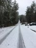
 I 85 and 385 , for my Greenville peeps!
 For posterity! It was so close to amazing here! Stuck at 34, what might have been!
Woke up with 2" on the ground and sleet/frzn falling. 25miles South East of Raleigh Center. I swear I can actually see snow falling about 1 mile north of me.
I'm about to go up to Ober with my kids and they're so excited it finally switched. Now to see how long it lasts!We've been switching p-types all morning in Gatlinburg but its finally all snow with decent flakes. Just in time for us to leave.
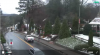
my yard is similar to yours with about 1/2inch+ more sleet, still sleeting, heavy sleet!View attachment 8971 I will rebuild!
Man it was close. It was pounding snow for several hours. Sleet worked itself in on radar, then it changed to heavy 32 degree rain. We had an outside chance of keeping that CC line to our south through the early morning. Oh well. Not bad for Dec 10View attachment 8975 For posterity! It was so close to amazing here! Stuck at 34, what might have been!
Man it was close. It was pounding snow for several hours. Sleet worked itself in on radar, then it changed to heavy 32 degree rain. We had an outside chance of keeping that CC line to our south through the early morning. Oh well. Not bad for Dec 10
Its Dec 9, not Dec 10Man it was close. It was pounding snow for several hours. Sleet worked itself in on radar, then it changed to heavy 32 degree rain. We had an outside chance of keeping that CC line to our south through the early morning. Oh well. Not bad for Dec 10
Only a cold rain hereI was expecting to see a lot of ice storm pics in GA and havent seen any yet.....
I was expecting to see a lot of ice storm pics in GA and havent seen any yet.....