• Hello, please take a minute to check out our awesome content, contributed by the wonderful members of our community. We hope you'll add your own thoughts and opinions by making a free account!

Pattern Arid August

Wondering if we break 80 today. NAM thinks TDF spends most of the day in the upper 60s
I hear you. I'm doubting we will break 70 here. Sitting at 68 and rain is locked in for a good while at least.

And its a shame wild growing mushrooms aren't worth any monetary value. They have popped up everywhere
 
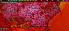
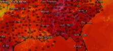
Man the latest GFS run is absolutely BRUTAL for the middle of the county, with 110s for Brent, and brings back mid to upper 90s for many of us. Likely overdone but no signs there of a seasonal backing off of temps. Hopefully that will end up looking different with future runs.
 
Man the latest GFS run is absolutely BRUTAL for the middle of the county, with 110s for Brent, and brings back mid to upper 90s for many of us. Likely overdone but no signs there of a seasonal backing off of temps. Hopefully that will end up looking different with future runs.
Although the GFS maybe a tad too warm, I have no delusions that the summer heat and above normal temperatures are finished yet. Even though the days are getting noticeably shorter in August, there is still enough sun to provide some miserable days to come when the conditions are right.
 
Man the latest GFS run is absolutely BRUTAL for the middle of the county, with 110s for Brent, and brings back mid to upper 90s for many of us. Likely overdone but no signs there of a seasonal backing off of temps. Hopefully that will end up looking different with future runs.
Keep it down there! FA22A6C4-A90F-4E03-84B1-64A8CD084ED6.png
 
Man the latest GFS run is absolutely BRUTAL for the middle of the county, with 110s for Brent, and brings back mid to upper 90s for many of us. Likely overdone but no signs there of a seasonal backing off of temps. Hopefully that will end up looking different with future runs.
Wow that looks rough for Texas and Oklahoma, but you can probably knock 8-10 degrees off. That still leaves highs of around 110 for a couple of days. That actually does not look too bad for us since you can probably knock off 3-5 degrees from what it shows in our area. We would possibly get into a very nasty MCS track here with that setup.
 
Wow that looks rough for Texas and Oklahoma, but you can probably knock 8-10 degrees off. That still leaves highs of around 110 for a couple of days. That actually does not look too bad for us since you can probably knock off 3-5 degrees from what it shows in our area. We would possibly get into a very nasty MCS track here with that setup.
With as dry as the ground is here, I fully expect temps to overperform. We are in desperate need of some rain and I don't see much in the next 10 days.
 
Man the latest GFS run is absolutely BRUTAL for the middle of the county, with 110s for Brent, and brings back mid to upper 90s for many of us. Likely overdone but no signs there of a seasonal backing off of temps. Hopefully that will end up looking different with future runs.
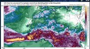
The Euro is much cooler and hopefully right. Only Texas gets 100+ and then only up to around 102-105 or so.
 
69 degrees at 2;30 pm on August 13th. Can we stay below 70 a couple of more hours? Always a win when you bust on the cooler side of forecasted Highs, no matter what season we are in. Spring included for me.
 
MJO phases 3 and 4 are big heat ridge phases in the central US leaned up into the lakes and southern Canada. The SE gets variable as westerly midlevel flow advects in the high 850s but the pattern often drops MCS/shortwaves down the eastern flank of the ridge keeping the heat in check especially the farther east you go. If the MJO continues to motor along the heat ridge gets muted in P5, P6 tries to trough the central and eastern US, then 7/8 get into a favorable hurricane landfall pattern with AN heights across Canada toward Greenland
 
69 degrees at 2;30 pm on August 13th. Can we stay below 70 a couple of more hours? Always a win when you bust on the cooler side of forecasted Highs, no matter what season we are in. Spring included for me.
And here I am at 94 degrees. You must have some clouds today.
 
MJO phases 3 and 4 are big heat ridge phases in the central US leaned up into the lakes and southern Canada. The SE gets variable as westerly midlevel flow advects in the high 850s but the pattern often drops MCS/shortwaves down the eastern flank of the ridge keeping the heat in check especially the farther east you go. If the MJO continues to motor along the heat ridge gets muted in P5, P6 tries to trough the central and eastern US, then 7/8 get into a favorable hurricane landfall pattern with AN heights across Canada toward Greenland

Just in time for peak season oof.


Sent from my iPhone using Tapatalk
 
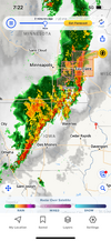
The 18z GFS is going to be rough in Texas and Oklahoma again and has our area in a decent northwest flow. If it is right, we will have to watch the MCS track from Sat at least through Monday, if not longer, while the southern plains go to 110+. Some areas may not go below 90 at night either out there.
 
Last night was the most pleasant night I can remember in many weeks. Still warm and humid but not stifling and a great breeze.
 
MJO phases 3 and 4 are big heat ridge phases in the central US leaned up into the lakes and southern Canada. The SE gets variable as westerly midlevel flow advects in the high 850s but the pattern often drops MCS/shortwaves down the eastern flank of the ridge keeping the heat in check especially the farther east you go. If the MJO continues to motor along the heat ridge gets muted in P5, P6 tries to trough the central and eastern US, then 7/8 get into a favorable hurricane landfall pattern with AN heights across Canada toward Greenland
Well, if the MJO works out like it does for winter and snow then we have nothing to worry about
 
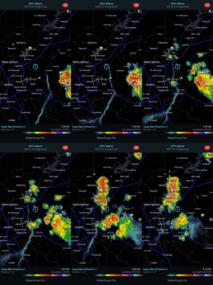
Getting afternoon pop-up early today as it started just after 1PM. Moving in a somewhat SW direction. Second PM pop up since Debby and first in 3 days. Already letting up after a short heavy period.
 
Back
Top