Nice change from the 100s but still would like to see some dews below 70.
74/71
74/71
This 2nd round is going to miss me too. This area is cursed like no other.
The GFS will be right. I guarantee it.
You are a hard one to figure out. Every now and then you make some good thoughtful posts but the rain fixation is hard to understand. You live in SC, which is in the SE. Outside the PNW, this is the rainiest area of the country. Even in the driest years on record, the area gets 30 plus inches of rain, and most years we get 40, 50, or even 60+.That's more than we will see before Thanksgiving over here.


Nice change from the 100s but still would like to see some dews below 70.
74/71
Looks like mid 60s in the area now.Nice change from the 100s but still would like to see some dews below 70.
74/71

That would be terrible if the game is rained outIn Bristol Tenn. for the Braves Reds game. Rain delay.
Get it going as soon as you can. Salvage attendance and viewership if they play tonight even delayed. Also, no guarantees that cell survives.Looks like a break here soon in the rain at the track but another cell may be there in 30-45. Wonder if they’ll start our just wait
Man. A familiar site of a wet Bristol, I’ve been to more than one rain delayed race there
I almost got tickets for this one. Let me know how it goes! Looks like a big time
Man. A familiar site of a wet Bristol, I’ve been to more than one rain delayed race there
Come north young man but leave the snow shield behind please.Thinking about leaving too. People are getting more rain today than I had in all of July, its really tiresome
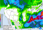
Which run? The 0z showed a ton of rain “ by comparison” in the area on both?I see neither the GFS nor the Euro are backing off their solutions. My money is on the GFS. I guarantee it'll verify
The 6z GFS is back to basically dry for 10 days for most of the Carolinas.Which run? The 0z showed a ton of rain “ by comparison” in the area on both?
I'll say 1 thing though. It's hard to ignore the Canadian, Euro, Icon, and the UKMET, but the GFS is not moving an inch. This would most likely be much more stratiform too, meaning all of us get good rain if those models are right.As long as the gfs keeps developing that tropical system in the wake of 95l its going to be the drier model. It's a hard scenario to believe but anything is possible i suppose

Dude you don't have a clue do ya??The 12z GFS is still dry over most of the Carolinas over the next few days. The other models will most likely join it today.