• Hello, please take a minute to check out our awesome content, contributed by the wonderful members of our community. We hope you'll add your own thoughts and opinions by making a free account!

Tropical 94L - PTC to be issued later today

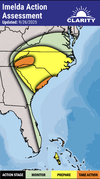
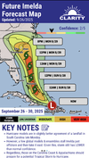
Didn't post my morning thoughts in here but I swear, I do think the storm might be listening to me. I said it's moving day today if something interesting is to form, and it looks like it's starting to try and organize and head towards the Bahamas as expected.
 
what about the interaction with a modest ull? i'm not well versed in dynamics
at this point it looks like landfall should be removed from the ULL's existence enough that there wouldn't be much enhancement of rain from ULL. sorta just a little trough left behind that helps pull Imelda in
 
Just my two cents. But to get 20+ inch rainfall totals anywhere from this, it would require a stall right along the coastline so convection can continue to fire from the Atlantic. Maybe similar to what Harvey did.

That’s very much still on the table though.
 
dont know where it goes, but seems like the 12z ukmet took a major shift vs it's 00z run towards more of a threat. probably still ots
 
12Z:
CMC does a loop and then comes back to NC

JMA hints at OTS but not sure since only to 72

UKMET goes OTS again like the Icon although it goes further NW than prior runs before going OTS

NEW TROPICAL CYCLONE FORECAST TO DEVELOP AFTER 42 HOURS
FORECAST POSITION AT T+ 42 : 23.3N 76.7W

LEAD CENTRAL MAXIMUM WIND
VERIFYING TIME TIME POSITION PRESSURE (MB) SPEED (KNOTS)
-------------- ---- -------- ------------- -------------
1200UTC 28.09.2025 48 24.2N 76.7W 1007 33
0000UTC 29.09.2025 60 25.2N 77.4W 1004 34
1200UTC 29.09.2025 72 26.7N 77.8W 1003 38
0000UTC 30.09.2025 84 28.2N 77.6W 1001 36
1200UTC 30.09.2025 96 28.9N 78.5W 996 42
0000UTC 01.10.2025 108 28.7N 77.8W 994 40
1200UTC 01.10.2025 120 28.5N 76.6W 992 38
0000UTC 02.10.2025 132 28.7N 74.3W 991 46
1200UTC 02.10.2025 144 28.9N 72.2W 991 54
0000UTC 03.10.2025 156 28.7N 69.6W 992 63
1200UTC 03.10.2025 168 28.6N 68.4W 995 52
 
Those to the NW of this are likely to get a TON of rain if it makes landfall. Would not be surprised to see a wide swath of 8-16" of rain in the upstate and mountains
 
Wouldn’t this be similar to Debbie from last year?
Been trying to find a similar situation to this and failing (namely a stalling SC landfall inland). Debbie might be one of the closest since it came ashore at a friggin crawl. Will say it picked up speed afterwards, so maybe not the best comparison (but perhaps the best we have).

Honestly I can't recall any SC landfalls that stalled like this one potentially. If anyone has an example, please share.

florence from 2018 might be close, cant remember if it made landfall in sc or not though
 
Been trying to find a similar situation to this and failing (namely a stalling SC landfall inland). Debbie might be one of the closest since it came ashore at a friggin crawl. Will say it picked up speed afterwards, so maybe not the best comparison (but perhaps the best we have).

Honestly I can't recall any SC landfalls that stalled like this one potentially. If anyone has an example, please share.
1940 Hurricane that landfalled around Savannah lingered for multiple days...
August_1940_rainfall.png
 
looks like a stronger pull, so 12z euro will probably make landfall in future frames
 
Fwiw, the 12z hurricane models all look like Cat 1-2 hurricanes to me. Supposedly the one that's been most accurate on 94L's positioning is the HMON and it seems like it comes in just north of Charleston.
 
florence from 2018 might be close, cant remember if it made landfall in sc or not though
Officially NC, but then crawled into N SC. Might be a better comparison though. Florence totals..

Hurricane_Florence_rainfall.png

So taking this verbatim with Charleston landfall instead of Wilmington, above would shift with SC taking the brunt of it. Not a great scenario obviously.

Still too early, but food for thought.
 
Feels like models have had a poor track record of intensity forecasts in the short term last few seasons. Really concerning if we see a Humberto type RI the sc coast will have no time to react. Many expecting a low end cat 1 and likely making minimal preparations.
 
dang, 12z euro just dances off shore. humberto is leaving. i expect big time rainfall maps along the coast
 
what a bad result on this euro run, not good

finally coming inland south of chs by 144

what a nightmare
 
Aren't the water temps off the South Carolina coast only in the 70s ? Wouldn't that cause some weakening ?
Yeah. The water temps are actually in the 70s. Looking at the wind structure on the EURO, it implies that its a left side half a cane meaning dry air is wrapping on the southern side of 94L (upper low influenced). Should "cap" 94L's intensity somewhat but not the rainfall potential
 
Yeah, it looks like on the 500 mb maps that Humberto tries to capture it and fails, and we end up with it just meandering around and hammering the coast with rain.

Bad, bad, bad...
 
Back
Top