-
Hello, please take a minute to check out our awesome content, contributed by the wonderful members of our community. We hope you'll add your own thoughts and opinions by making a free account!
You are using an out of date browser. It may not display this or other websites correctly.
You should upgrade or use an alternative browser.
You should upgrade or use an alternative browser.
Tropical 92L
- Thread starter SD
- Start date
Downeastnc
Member
Looks like the eastern side firing up is trying to pull the llc east
Downeastnc
Member
Looks like the eastern side firing up is trying to pull the llc east
Yeah I aint gonna lie I am like snatch that thing back offshore and march due north lol....
I'm having a hard time seeing tomorrow being convection free along and E of US1 like some of the models are showing with the moisture plume advecting north and the piedmont trough sharpeningYeah I aint gonna lie I am like snatch that thing back offshore and march due north lol....
Downeastnc
Member
I'm having a hard time seeing tomorrow being convection free along and E of US1 like some of the models are showing with the moisture plume advecting north and the piedmont trough sharpening
Need it to form a new center back over water or at least keep that deeper convection going until it moves more north to give us a chance at some rain Sunday/Monday.
I’ve had ~1/3” of rain the last ~12 hrs here in the SAV area from several feeder bands. However, just a few miles S where a couple of the bands lined up better there was ~1”. Skies are tropical looking/mostly cloudy with steady E winds of 15 gusting to 20 here on the N side of the circ (a little breezier than yesterday and up a bit since a few hours ago), which appears to be centered ~50 mi SSW of me in ~N McIntosh Cty. To the S of the LLC, winds are SW at 15 in Brunswick area.
There’s still a fairly well defined weak low within a pretty high SLP background. Not much is changing as far as the strength of the low is concerned. It is barely onshore drifting slowly N toward here as of now.
If you go to this link and animate it, you can clearly see the LLC centered about midway between SAV and SSI: check out all of the little pop up showers

 weather.cod.edu
There’s still a fairly well defined weak low within a pretty high SLP background. Not much is changing as far as the strength of the low is concerned. It is barely onshore drifting slowly N toward here as of now.
If you go to this link and animate it, you can clearly see the LLC centered about midway between SAV and SSI: check out all of the little pop up showers

COD-NEXLAB : Dual-Pol Radar for CLX
Dual-Pol NEXRAD Data for provided by College of DuPage Meteorology (NEXLAB)
Last edited:
2PM TWO:
Near the Georgia Coast (AL92):
Showers and thunderstorms associated with a low pressure system
centered just inland over southeastern Georgia have decreased
during the past several hours. The low is expected to drift slowly
north-northeastward near the coasts of Georgia and southern South
Carolina through tonight before dissipating by Sunday. Tropical
cyclone formation is not expected.
* Formation chance through 48 hours...low...near 0 percent.
* Formation chance through 7 days...low...near 0 percent.
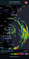
For the first time since 92L started affecting this area, we’re getting thunderstorms. The rainfall has been quite heavy and is training within a band moving NNW from the ocean. There are no warnings yet out for this county, but very likely this has already caused street flooding.
It isn’t the red area on this image but rather the small blue/green area to its NE:

*Edit: I ended up with a little over 2” during ~2 hour period with most of that falling within an hour.
10AM: LLC now over SE SC (near Beaufort)
It isn’t the red area on this image but rather the small blue/green area to its NE:

*Edit: I ended up with a little over 2” during ~2 hour period with most of that falling within an hour.
10AM: LLC now over SE SC (near Beaufort)
Last edited:


