• Hello, please take a minute to check out our awesome content, contributed by the wonderful members of our community. We hope you'll add your own thoughts and opinions by making a free account!

Severe 6/24-6/25/23 severe weather

Shaggy

Member
Joined
Jan 26, 2019
Messages
14,144
Reaction score
11,729
Location
Greenville,nc
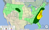
Lots of big potential for the Vjrginia and NC crowd as a MCS fires up and moves east. SPC calls for supercells early with 2+ inch hail threats for any supercells that get going. Gonna be a long afternoon for the local NWS offices
 
Possible severe today too for the western Carolinas into north GA with an MCS coming out of Tenn. Tomorrow looks rough especially east of I-77 in NC and VA. I would not be shocked to see a moderate risk for a small part of both states.
 
Possible severe today too for the western Carolinas into north GA with an MCS coming out of Tenn. Tomorrow looks rough especially east of I-77 in NC and VA. I would not be shocked to see a moderate risk for a small part of both states.
Yeah the Midwest down to the are you highlighted under the gun today and all that shifts east tomorrow. Awaiting the the day 2 spc disco soon.
 
day1otlk_1300.gif


day2otlk_0600.gif
 
Level 3 threat for tomorrow.

model forecasts suggests the greatest instability will develop from
central North Carolina into southern and central Virginia, where
MLCAPE values appear likely to reach the 2000 to 3000 J/kg range. In
addition to moderate instability, NAM forecast soundings near
Richmond, Virginia and Raleigh, North Carolina have steep mid-level
lapse rates with relatively cool temperatures aloft. This, combined
with 0-6 km shear in the 30 to 35 knot range will likely support
supercell development. The potential for supercells will be greatest
early in the afternoon, before storms merge into a line. Hailstones
of greater than 2 inches in diameter will be possible with
supercells that develop in areas that destabilize the most. The
current thinking is that a relatively quick transition to a line
will occur. This line is forecast to become organized, moving
eastward across the Piedmont into the Raleigh/Durham and Richmond
areas during the late afternoon. Wind-damage will be likely along
the leading edge of the stronger parts of this line segment.spccoday2.categorical.latest.png
 
Level 3 threat for tomorrow.

model forecasts suggests the greatest instability will develop from
central North Carolina into southern and central Virginia, where
MLCAPE values appear likely to reach the 2000 to 3000 J/kg range. In
addition to moderate instability, NAM forecast soundings near
Richmond, Virginia and Raleigh, North Carolina have steep mid-level
lapse rates with relatively cool temperatures aloft. This, combined
with 0-6 km shear in the 30 to 35 knot range will likely support
supercell development. The potential for supercells will be greatest
early in the afternoon, before storms merge into a line. Hailstones
of greater than 2 inches in diameter will be possible with
supercells that develop in areas that destabilize the most. The
current thinking is that a relatively quick transition to a line
will occur. This line is forecast to become organized, moving
eastward across the Piedmont into the Raleigh/Durham and Richmond
areas during the late afternoon. Wind-damage will be likely along
the leading edge of the stronger parts of this line segment.View attachment 135552
Wouldn't be surprised to see the enhanced area expand west into the western piedmont. New disco will be out shortly
 
Last night I was in Waterloo for this beast! 033560C8-3C74-461B-8CE9-73F1432C7018.png297C9586-4AFF-4AA4-A020-B7D2154ECF51.jpegDEE50E90-3B81-410F-99C2-29CF80652A3D.jpeg60705501-13C3-4AB2-8625-5ACF9092DDE5.jpeg
 
It'll be interesting to see how quickly tomorrow goes linear. Any discreet cells early in the life cycle of the event will have a higher likelihood of dropping golf ball or potentially larger hail. As the line congeals wind will be the primary threat with a well defined ofb ahead of the main line of storms. Additionally there is a lower threat of flash flooding as storms may attempt to redevelop and train behind the initial line tomorrow evening
 
Back
Top