-
Hello, please take a minute to check out our awesome content, contributed by the wonderful members of our community. We hope you'll add your own thoughts and opinions by making a free account!
You are using an out of date browser. It may not display this or other websites correctly.
You should upgrade or use an alternative browser.
You should upgrade or use an alternative browser.
Severe 3/23-26 Severe Weather
- Thread starter SD
- Start date
Moderate risk issued.
Had a dry forcast from tv mets early this morning before heading out to church. Since then thunder an rain on and off all day
- Joined
- Jan 5, 2017
- Messages
- 3,769
- Reaction score
- 5,966
That storm west of Montgomery looks like it has a hook on it. Not sure why it doesn't have some kind of warning...
Rotation too weak.That storm west of Montgomery looks like it has a hook on it. Not sure why it doesn't have some kind of warning...
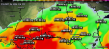
I don’t ever put much stock in the HRRR, but the 17z is wicked.
HugeSnowStick
Member
SPC Day 1 Outlook
Severe weather, tornado, thunderstorm, fire weather, storm report, tornado watch, severe thunderstorm watch, mesoscale discussion, convective outlook products from the Storm Prediction Center.
www.spc.noaa.gov
A trio of tornado warnings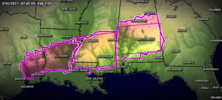
Radar loop with severe tstorm warnings (red) and tor warnings (purple)
View attachment 032623.mp4

Radar loop with severe tstorm warnings (red) and tor warnings (purple)
View attachment 032623.mp4
Most of these storms are in the same if not exact locations from the morning storms. I hope everyone in this systems path stays safe tonight!! My aunt in LaGrange/Lanett area is planning on sleeping in her closet tonight!
BufordWX
Member
Oof!!!
Severe Weather Statement
National Weather Service Peachtree City GA
921 PM EDT Sun Mar 26 2023
GAC063-113-121-270130-
/O.CON.KFFC.SV.W.0118.000000T0000Z-230327T0130Z/
Fayette GA-Fulton GA-Clayton GA-
921 PM EDT Sun Mar 26 2023
...A SEVERE THUNDERSTORM WARNING REMAINS IN EFFECT UNTIL 930 PM EDT
FOR NORTHERN FAYETTE...SOUTH CENTRAL FULTON AND NORTHERN CLAYTON
COUNTIES...
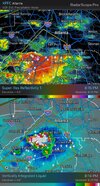
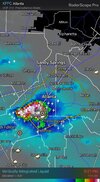
At 921 PM EDT, a severe thunderstorm was located over Union City, or
8 miles southeast of City of South Fulton, moving northeast at 40
mph.
HAZARD...Tennis ball size hail and 60 mph wind gusts.
SOURCE...Radar indicated.
IMPACT...People and animals outdoors will be injured. Expect hail
damage to roofs, siding, windows, and vehicles. Expect wind
damage to roofs, siding, and trees.
Locations impacted include...
Atlanta, Jonesboro, City of South Fulton, East Point, Union City,
Forest Park, Riverdale, College Park, Fairburn, Tyrone, Morrow,
Hapeville, Palmetto, Lake City, Hartsfield-Jackson Airport, Cascade
Heights, Lakewood Park, Sandy Creek, Conley and Sandtown.
PRECAUTIONARY/PREPAREDNESS ACTIONS...
For your protection move to an interior room on the lowest floor of a
building.
&&
LAT...LON 3359 8472 3377 8452 3369 8436 3365 8435
3365 8434 3354 8429 3346 8457 3351 8462
3351 8463
TIME...MOT...LOC 0121Z 234DEG 35KT 3358 8450
THUNDERSTORM DAMAGE THREAT...CONSIDERABLE
HAIL THREAT...OBSERVED
MAX HAIL SIZE...2.50 IN
WIND THREAT...RADAR INDICATED
MAX WIND GUST...60 MPH
$$
bingcrosbyb
Member
Most of these storms are in the same if not exact locations from the morning storms. I hope everyone in this systems path stays safe tonight!! My aunt in LaGrange/Lanett area is planning on sleeping in her closet tonight!
I've been watching LaGrange off and on in particular day. They've been ground zero for all of the flash fooding and severe t'storms so far.
Not quite tennis ball size where I am, but the hail was golf ball size. I recorded a clip of it from my front porch. I’ll try to post it when I can.
It seems the cell peaked in intensity bwtween Newnan and downtown Atlanta. Palmetto, Fairburn, Union City and the Airport all appeared to have got slammed with the largest hail, per the radar indication
HugeSnowStick
Member
The light show is insane..
Right before the hail moved in it was lightning over here about every 2 seconds. It was pretty intense.The light show is insane..
Serious flooding situation developing
Brent
Member
Wow at the rain. Holy cow and it’s been worse a few miles to my south. I’m not even gonna try to take my normal route to work because I know it’s underwater.
Cbmatt2408
Member
We got hammered for pretty much 22 of the last 26 hours. Woke up to the tornado siren yesterday and a lightning show that was insane. Last night was just one strong storm after another and we registered just under 9" of rain in the gauge before I left this morning at 7. This has been a crazy year to date, 4 confirmed tornadoes within 20 miles in under 3 months. Yesterday being the largest, luckily in a fairly lower population area, but still a lot of damage.I've been watching LaGrange off and on in particular day. They've been ground zero for all of the flash fooding and severe t'storms so far.
Right there with you in Mcdonough.....just didn't get any tornado warnings.....this time.....but January was a different storyWe got hammered for pretty much 22 of the last 26 hours. Woke up to the tornado siren yesterday and a lightning show that was insane. Last night was just one strong storm after another and we registered just under 9" of rain in the gauge before I left this morning at 7. This has been a crazy year to date, 4 confirmed tornadoes within 20 miles in under 3 months. Yesterday being the largest, luckily in a fairly lower population area, but still a lot of damage.
Idk if it was the excitement of it in the moment or what, but looking back over the clip I recorded it definitely wasn't golf ball size either, more like quarter size. It sure seemed bigger in real time then.?Not quite tennis ball size where I am, but the hail was golf ball size. I recorded a clip of it from my front porch. I’ll try to post it when I can.

