-
Hello, please take a minute to check out our awesome content, contributed by the wonderful members of our community. We hope you'll add your own thoughts and opinions by making a free account!
You are using an out of date browser. It may not display this or other websites correctly.
You should upgrade or use an alternative browser.
You should upgrade or use an alternative browser.
Severe 3/23-26 Severe Weather
- Thread starter SD
- Start date
Darklordsuperstorm
Member
Birmingham being a little bit bullish with this system.
The warmth will continue into Friday as an upper-level trough
takes shape over the Southern Plains and Mississippi Valley. The
nearby ridge should hold a lid on convection through most of the
day before relenting in the evening. Dewpoints during the
afternoon should dip into the upper 50s and lower 60s due to
shallow quality moisture depth associated with low-level
anticyclonic curvature. Moisture quality should increase across MS
and AL late in the afternoon through the evening as the surface
pressure pattern and height pattern takes on more cyclonic
curvature. This is also when the severe weather threat should
increase. Storms should develop and mature over Mississippi during
the late afternoon and early evening and cross through Alabama
during the night. Dewpoints in the mid to upper 60s and surface
temperatures in the lower 70s through the evening and overnight,
may support MLCAPE of 700-1000 J/kg. Hodographs are expected to
become increasingly large as the low-level jet strengthens to
around 50 kts. The low-amplitude nature of the 500 mb trough with
broad cyclonic curvature, and 200-250 mb diffluence overspreading
the warm sector, indicates that supercells will be a part of the
equation. Assuming sufficient instability moves into our forecast
area, relatively strong height and pressure falls suggest the
threat for tornadoes and damaging winds could be elevated.
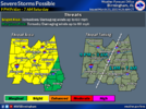

Bham still going for event. Wording sure has my attention.
LONG TERM...
(Thursday through Tuesday)
Issued at 351 AM CDT WED MAR 22 2023
Thursday night through Tuesday.
An upper-level ridge will shift eastward Thursday night and
Friday, paving the way for strengthening southerly flow and
positive theta-e advection. As expected, the NBM has trended
downward significantly with POPs for Friday afternoon due to
subsidence associated with influence of the nearby ridge.
Dewpoints during the afternoon should dip into the upper 50s and
lower 60s due to shallow quality moisture depth associated with
low-level anticyclonic curvature. Moisture quality will increase
across MS and AL through the evening as the surface pressure
pattern and height pattern takes on more cyclonic curvature.
From a synoptic perspective, there are several bullish factors
pointing toward a potentially significant severe weather event
across the MS/AL region. In fact, the shape of the 500mb trough on
the global models is classic and suggestive of a tornado outbreak
across the Deep South. Of course there are other ingredients that
need to fall into place for that potential to be realized, but we
are seeing trends in that direction. Moisture quality and
instability has improved when looking at the trend of 850-925 mb
dewpoints, but models are very likely not handling the lowest part
of the boundary layer correctly during the overnight hours.
Temperatures on Friday will reach the 80s across the region, and
there is no good reason why temperatures should fall into the mid
to upper 60s during the evening in the midst of southerly winds
and an increasing low-level jet, as shown by some models.
Correcting for this bias suggests that temperatures will be in the
70-73F range as dewpoints increase into the mid to upper 60s.
This should yield more instability than currently depicted by the
GFS and ECMWF. Additionally, cold advection at 500mb is being
indicated, and the leading edge of this appears to be paired with
the expected corridor of severe storms. This should help maintain
or enhance mid-level lapse rates through the event, while
tempering the effects of latent heat release and not allowing the
atmosphere to turn over.
The low-amplitude nature of the 500 mb trough with broad cyclonic
curvature, and 200-300 mb diffluence overspreading the warm sector,
indicates that discrete supercells or line-embedded supercells
could be the primary storm mode. This has been explicitly
indicated by the ECMWF for several days.
Storms should develop and mature near the Mississippi River during
the late afternoon and early evening and move across Alabama
during the night. The environment should be characterized by
MLCAPE of 600-1000 J/kg spread efficiently throughout the column,
and increasingly large hodographs as the low-level jet increases
to 50-55 kts. Assuming this amount of instability develops,
relatively strong height and pressure falls suggest the threat for
tornadoes and damaging winds could be elevated.
Our public severe weather graphic will remain unchanged to remain
somewhat consistent with other national products, but an upgrade
may become necessary tomorrow night.
Dry conditions should return by sunrise on Saturday as the system
moves quickly to the east. The associated frontal passage will be
rather weak as low-amplitude west-southwest flow continues aloft.
The front to our south is expected return northward and become
nearly stationary for Sunday through Tuesday with increasing
instability and the potential for numerous showers and
thunderstorms.
87/Grantham
bouncycorn
Meteorologist
MMFS-AI Tornado Model


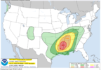
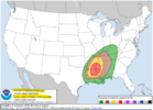
ENHANCED RISK OUT NOW
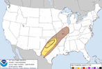
y 2 Convective Outlook
NWS Storm Prediction Center Norman OK
0100 AM CDT Thu Mar 23 2023
Valid 241200Z - 251200Z
...THERE IS A MODERATE RISK OF SEVERE THUNDERSTORMS ACROSS NORTHEAST
LOUISIANA...SOUTHEAST ARKANSAS...AND WESTERN MISSISSIPPI...
...SUMMARY...
Supercell thunderstorms capable of all severe hazards, including
strong tornadoes, are possible across the Lower Mississippi Valley
on Friday.
...Synopsis...
Upper troughing is expected to be in place over the western CONUS
early Friday morning. Strong mid-level flow will extend throughout
the periphery of this trough into the more confluent flow north of
the subtropical ridging across the eastern CONUS. A shortwave trough
is forecast to move through this enhanced mid-level flow, tracking
quickly eastward across the southern Plains during the day, and more
northeastward into the Mid MS Valley overnight. Mid-level flow is
expected to strengthen as the shortwave moves eastward, with 100+ kt
at 500 mb spreading across TX into the Mid-South.
At the surface, a low initially over north TX is forecast to move
northeastward ahead of the approaching shortwave, moving into
northern AR by Friday evening and through the Lower OH Valley
overnight. This low is expected to deepen throughout the day, and
this cyclogenesis will result in a broad area of moderate southerly
flow across the Lower MS Valley/Mid-South into the Southeast and TN
Valley. Environmental conditions appear favorable for numerous
severe thunderstorms from the Lower MS Valley through the Mid-South
and into the Mid MS and Lower OH Valleys.
...Lower MS Valley into the Southeast...
A broad warm sector, characterized by dewpoints in the upper 60s, is
forecast to be in place from east TX across much of the Lower MS
Valley and Mid-South early Friday morning. Thunderstorms may be
ongoing early Friday morning along a cold front moving eastward
across east TX. This cold front is expected to make gradual eastward
progress, as its parent surface low deepens while moving from
eastern OK into AR. This overall evolution will contribute to a
continued mass response across the warm sector, with low-level
moisture increasing throughout the day amid strengthen southerly
flow. This increase in low-level moisture coupled with modest
heating is expected to result in airmass destabilization during the
late afternoon. This destabilization coupled with large-scale ascent
attendant to the approaching shortwave (perhaps augmented by
low-level confluence) will likely result in discrete thunderstorm
development within the warm sector ahead of the front.
Current thinking is that this initial development is most likely to
occur in the TX/LA border vicinity. The downstream air mass will be
moderately buoyant, with guidance suggesting MLCAPE around 1000-1500
J/kg and max 2-6 km AGL lapse rates around 8 deg C per km. Robust
vertical shear is also expected, with a strong low-level jet (i.e.
50-60 kt at 850 mb) developing during the evening beneath
strengthening mid-level flow. Forecast hodographs depict
substantial low-level speeds and veering, with 0-1 km storm-relative
helicity from 200 to 300 m2/s2. A discrete supercell mode is
anticipated initially, with all severe hazards possible, including
strong tornadoes. With storms expected to develop in the LA/TX
border vicinity, discrete storm maturation is anticipated across
northeast LA, southeast AR, and western MS.
Upscale growth into a convective line is anticipated after this
initially discrete mode, with the line pushing eastward across MS
and AL overnight. Robust kinematic fields are expected to persist,
support a continued threat for strong gusts and line-embedded
tornadoes.
...Mid-South into the TN and Lower OH Valleys...
A more convoluted convective evolution is anticipated from
central/northern AR northeastward into the Lower OH Valley on
Friday. Storms will likely be ongoing along and north of stationary
boundary extending from east-central OK northeastward into northern
KY. A low-probability threat for hail is expected throughout the
morning and into the early afternoon as warm-air advection promotes
continued thunderstorm development along this boundary.
A gradual increase in storm intensity is then expected during the
afternoon as the surface low begins to deepen across AR and
large-scale forcing for ascent attendant to the shortwave increases.
Buoyancy will be more modest than areas farther south, but the
strong ascent and increasing shear is still expected to support
intense updrafts. Given the presence of the stationary front and
stronger forcing, a linear mode is anticipated, with this line then
progressing quickly east-northeastward across the Mid-South during
the evening and into more of the Lower OH and TN Valleys overnight.
Strong wind gusts will be primary hazard within this line, but
line-embedded tornadoes will be possible as well.
..Mosier.. 03/23/2023
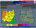
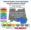
NEW NWS BMX
LONG TERM...
(Friday night through Wednesday)
Issued at 330 AM CDT THU MAR 23 2023
Friday night into Saturday
The signal of a severe weather event late Friday night and into the
early morning hours Saturday continues to increase, with potential
for tornadoes and damaging winds to move across the area. A
negatively tilted trough will move across the Central Plains and
toward to Upper Midwest overnight Friday, with an accompanying
surface low moving northeastward from AR/OK into IN/MI. Model runs
have shown the potential for this low to deepen as time goes into
Saturday morning. Moisture feed looks to be plentiful overnight,
with dew points remaining in the mid to upper 60s across much of the
area along with temperatures likely staying in at least the low 70s
ahead of the storms. Along with an increasing low-level jet,
accompanied by height falls over the region, CAPE values will be on
the order of 700 to 1000 J/kg. Hodographs look supportive of
tornadic potential, along with over 250 m2/s2 low-level SRH. Initial
discrete convection to the west in the form of supercells will
likely grow upscale somewhat into a broken line of storms, with line-
embedded supercells possibly becoming the dominant storm mode moving
into Central Alabama. This broken line of storms will carry the
potential for tornadoes and severe damaging winds as it progresses
through the state during the overnight hours.
Beginning with this forecast update, our threat graphics have been
updated to include a higher-level risk for severe weather,
especially across the western counties, where instability and shear
will be greatest. The southeastern parts of the area cannot be
forgotten, as severe potential remains in areas along and south of
the I-85 corridor into Saturday morning, although carrying a lower
overall threat.
After the severe threat ends Saturday morning, Saturday afternoon
looks to be another warm day, with highs in the upper 70s to mid 80s
across the area .
Last edited:
Darklordsuperstorm
Member
Kudos to BMX they were on this thing a couple of days ago when the CWA wasn't even outlooked yet by SPC. They sniffed this one out early and rightly so. Potential coming together for a potentially significant event!
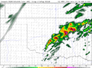
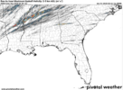
updraft helicity from the 3k
View attachment 032323.mp4
3k radar and spc day 2
View attachment 032323.mp4
View attachment 032323.mp4
3k radar and spc day 2
View attachment 032323.mp4
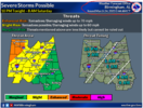
BMX HAS SOME DECENT WORDING THE LATEST AFD..
National Weather Service Birmingham AL
317 AM CDT Fri Mar 24 2023
...New SHORT TERM, LONG TERM...
.SHORT TERM...
(Today through Saturday)
Issued at 312 AM CDT FRI MAR 24 2023
It is a much warmer night than the previous several days, with lows
in the 60s overnight. There is potential for low clouds and/or foggy
conditions to develop this morning across the southern and
southeastern parts of the area before skies clear and temps warm
into the mid to upper 80s this afternoon. Surface winds will
increase during the evening hours, with gusts upwards of 30kts
possible going into the overnight ahead of the incoming severe
weather. A Wind Advisory was considered but will hold off at this
time. There is the potential to reassess at the next forecast update
later this morning.
Meanwhile, an approaching shortwave across the lower Plains will
move toward the Ohio Valley region tonight, with a strong mid-level
jet on the order of 90 kts as a result of the proximity to the ridge
of high pressure that has been stationed over Florida and the
Bahamas. In conjunction, a deepening surface low will make its way
from OK/AR toward IN/MI by this evening and tonight. The
accompanying front will be the focus for a severe weather outbreak
this evening and overnight, first originating around the Mississippi
River basin and moving eastward through the evening.
A strengthening 50-60 kt low level jet will move across the area
during the evening hours, and convection originating in AR/LA moving
eastward through MS will begin to grow upscale into a partially
broken but mostly intact line by the time it reaches northwest
Central Alabama around 4z/11pm. As mentioned in previous forecasts,
there is a high potential for instances of line-embedded supercells
to be tornadic as they enter the state, owing to modest CAPE values
of 700 to 1000 J/kg along with low-level SRH of up to 400 m2/s2 and
0-6 km bulk shear values on the order of 60 kts. Cold air advection
at the 500 mb level will aid in more robust updrafts, and a couple
tornadoes occurring within this broken line of embedded supercells
may potentially be more than just the garden-variety brief spinups
usually seen with QLCS events.
The greatest severe risk in Alabama currently falls from Tuscaloosa
northward toward Tennessee and westward to Mississippi. Confidence
has increased that areas such as the I-22 corridor from Jasper
northwestward will be at greatest risk for tornadoes and damaging
straight-line winds up to 60-70 mph. In the southwestern counties,
the line will likely be more broken in nature than to the north, but
guidence has shown CAPE values will likely be higher to the south.
If any storms are able to take advantage of the higher CAPE values
and slightly lower shear parameters, the tornado potential remains
decently strong.
As with any severe weather event in Alabama, especially those that
occur overnight, it is of utmost importance to stay tuned to the
evolution of the event in real-time and be prepared to take any
necessary precautions to protect life in the event of impactful
severe weather. Nocturnal severe weather, whether that be tornadoes
or damaging winds, is unfortuately far too common across Alabama,
and it is imperative to have safety plans in place in the event of a
severe weather risk.
As the event transitions eastward during the early morning hours,
the overall severe potential looks to be lessened. Instability will
remain present but a general lack of forcing over this part of the
area will limit the overall severe threat going into the daylight
hours Saturday morning.
The storms tonight will not have much of an impact of Saturday`s
highs, as all of Central Alabama looks to remain in the mid 70s to
mid 80s, a very warm and rain-free start to the weekend.
Downeastnc
Member
Holy crap Batman
Downeastnc
Member
Dang
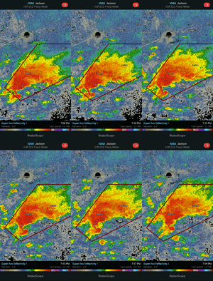
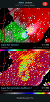
absolute monster tornado
absolute monster tornado
bingcrosbyb
Member
Reed timmer transporting severely injured to hospital

 www.youtube.com

Rolling Fork, MS Tornado Livestream - As It Happened
SITREP - Live storm chase mode has been activated for a dangerous tornado outbreak across Louisiana, Arkansas and Mississippi. This is live immersive storm c...
bingcrosbyb
Member
Downeastnc
Member
Looks like the tornado was pretty strong, lots of vehicles tossed about and fully razed structures....
Darklordsuperstorm
Member
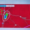
Gotta wonder if the streak is going to be broken tonight....

