-
Hello, please take a minute to check out our awesome content, contributed by the wonderful members of our community. We hope you'll add your own thoughts and opinions by making a free account!
You are using an out of date browser. It may not display this or other websites correctly.
You should upgrade or use an alternative browser.
You should upgrade or use an alternative browser.
Severe 3/21-3/24 Severe Weather
- Thread starter SD
- Start date
bingcrosbyb
Member
Amazing only 1 death from this tornado.
A band of moderate to heavy rain with likely embedded thunderstorms is to our SW and is moving NE toward this area, probably arriving within the next 1/2 hour. I’ll be bringing home my brother from the hospital (he has just been discharged), but will wait for this mess to go through first as I made the nurse aware of the bad wx coming and there’s flexibility on the timing.
Jessy89
Member

This cell near Knoxville rotating some
Sent from my iPhone using Tapatalk

Here comes the cape
NBAcentel
Member
Cape is basically on track like the HRRR has been showing
NBAcentel
Member
Satellite imagery showing breaks/some sun in SC and it’s moving north
Something I'm trying to understand is the relationship between cape and DP values. Is there a direct correlation? My weather station has gone from 50DP at 11pm to 66DP at 2:25pmCape is basically on track like the HRRR has been showing
Jessy89
Member
Tennessee and Kentucky just saw a explosion of severe thunderstorm warnings. Few of them has broad rotation
Sent from my iPhone using Tapatalk
Sent from my iPhone using Tapatalk
NBAcentel
Member
Dew points is a part of it, mid level lapse rates are another big part, but typically higher dews is more likely to have higher instability, unless mid levels are a issueSomething I'm trying to understand is the relationship between cape and DP values. Is there a direct correlation? My weather station has gone from 50DP at 11pm to 66DP at 2:25pm
HRRR really trying to do some refiring along the cold front in the overnight bourse from about Raleigh eastward .. could be interesting but obviously limiting factor being time of day
BufordWX
Member
Likely tornado in southern Georgia. Clinch county.
Hmmmm new HRRR fires cells up in the wake of morning rain but it seems to be too happy with initial conditions and how much rain there actually is around the area… 

lj0109
Member
Another brief TDS between Folkston and Race Pond GA:
lj0109
Member

Mesoscale Discussion 0326
NWS Storm Prediction Center Norman OK
0312 PM CDT Wed Mar 23 2022
Areas affected...Parts of the South Carolina into North Carolina
Piedmont
Concerning...Severe potential...Watch possible
Valid 232012Z - 232245Z
Probability of Watch Issuance...40 percent
SUMMARY...Scattered strong thunderstorm development, including one
or two supercells posing a risk for tornadoes, appears possible by
6-8 PM EDT. While it is not certain that a severe weather watch
will be needed, trends are being monitored for this possibility.
DISCUSSION...Low-level warm air and moisture advection, and
insolation with increasing breaks in cloud cover, are contributing
to gradual boundary-layer destabilization along a remnant surface
frontal zone across the Piedmont. With further insolation, and weak
cooling in the 700-500 layer forecast through late afternoon, models
suggest that mixed-layer CAPE on the order of 500-1000 J/kg may
develop. It appears that this will coincide with the
east-northeastward propagation of a 45-50 kt speed maximum around
850 mb.
Mid/upper forcing for ascent appears likely to remain generally
weak, but models have been suggestive that scattered discrete
thunderstorm development is increasingly possible through 22-00Z.
With deep-layer shear already strong, beneath 50-70 kt southwesterly
flow around 500 mb, enlarging, clockwise-curved low-level hodographs
may become favorable for the evolution of at least one or two
supercells that may pose a risk of producing tornadoes.
BufordWX
Member
Where did this guy come from? Lol
Jessy89
Member

Headed into South Carolina
Sent from my iPhone using Tapatalk
BufordWX
Member
Oh snap
BufordWX
Member
Tornado warning now.
JHS
Member
851
WFUS52 KGSP 232157
TORGSP
SCC001-007-232245-
/O.NEW.KGSP.TO.W.0001.220323T2157Z-220323T2245Z/
BULLETIN - EAS ACTIVATION REQUESTED
TORNADO WARNING
NATIONAL WEATHER SERVICE GREENVILLE-SPARTANBURG SC
557 PM EDT WED MAR 23 2022
THE NATIONAL WEATHER SERVICE IN GREENVILLE-SPARTANBURG HAS ISSUED A
* TORNADO WARNING FOR...
SOUTHEASTERN ANDERSON COUNTY IN UPSTATE SOUTH CAROLINA...
ABBEVILLE COUNTY IN UPSTATE SOUTH CAROLINA...
* UNTIL 645 PM EDT.
* AT 556 PM EDT, A SEVERE THUNDERSTORM CAPABLE OF PRODUCING A TORNADO
WAS LOCATED 11 MILES WEST OF ABBEVILLE, OR 4 MILES SOUTHEAST OF
LOWNDESVILLE, MOVING NORTHEAST AT 40 MPH.
HAZARD...TORNADO AND QUARTER SIZE HAIL.
SOURCE...RADAR INDICATED ROTATION.
IMPACT...FLYING DEBRIS WILL BE DANGEROUS TO THOSE CAUGHT WITHOUT
SHELTER. MOBILE HOMES WILL BE DAMAGED OR DESTROYED.
DAMAGE TO ROOFS, WINDOWS, AND VEHICLES WILL OCCUR. TREE
DAMAGE IS LIKELY.
* THIS DANGEROUS STORM WILL BE NEAR...
ABBEVILLE AND LAKE SECESSION AROUND 610 PM EDT.
OTHER LOCATIONS IMPACTED BY THIS DANGEROUS THUNDERSTORM INCLUDE
ANTREVILLE.
PRECAUTIONARY/PREPAREDNESS ACTIONS...
TAKE COVER NOW! MOVE TO A BASEMENT OR AN INTERIOR ROOM ON THE LOWEST
FLOOR OF A STURDY BUILDING. AVOID WINDOWS. IF YOU ARE OUTDOORS, IN A
MOBILE HOME, OR IN A VEHICLE, MOVE TO THE CLOSEST SUBSTANTIAL SHELTER
AND PROTECT YOURSELF FROM FLYING DEBRIS.
IF ON OR NEAR LAKE RUSSELL, GET AWAY FROM THE WATER AND MOVE TO SAFE
SHELTER IMMEDIATELY. IF YOU CAN HEAR THUNDER, YOU ARE CLOSE ENOUGH
TO BE STRUCK BY LIGHTNING. SEVERE THUNDERSTORMS CAN PRODUCE LARGE
CAPSIZING WAVES, EVEN ON SMALL BODIES OF WATER. MOVE INTO DOCK AND
SEEK SAFE SHELTER NOW! DO NOT BE CAUGHT ON THE WATER IN A
THUNDERSTORM.
PLEASE REPORT DAMAGING WINDS, HAIL, OR FLOODING TO THE NATIONAL
WEATHER SERVICE BY CALLING TOLL FREE, 1, 800, 2 6 7, 8 1 0 1, OR BY
POSTING ON OUR FACEBOOK PAGE, OR TWEET IT USING HASHTAG NWSGSP. YOUR
MESSAGE SHOULD DESCRIBE THE EVENT AND THE SPECIFIC LOCATION WHERE IT
OCCURRED.
LAT...LON 3408 8265 3409 8264 3411 8266 3413 8267
3415 8271 3418 8273 3419 8273 3443 8251
3416 8224 3413 8225 3406 8263
TIME...MOT...LOC 2156Z 232DEG 34KT 3417 8259
TORNADO...RADAR INDICATED
MAX HAIL SIZE...1.00 IN
Where are all the thunderstorms and flooding rains that we were supposed to get?
Shaggy
Member
Hrrr says wait a few more hoursWhere are all the thunderstorms and flooding rains that we were supposed to get?
SWVAwxfan
Member
Tornado watch for parts of SW VA. Wasn't expecting that.
Junkvection will always screw things up .. I’ll harp it to the day I dieWhere are all the thunderstorms and flooding rains that we were supposed to get?
How long has it been since we lost the clown ? emoji? I miss him!Where are all the thunderstorms and flooding rains that we were supposed to get?
BufordWX
Member
Some action has sparked up north of Greenville this evening. Multiple tornado warning. There are also unconfirmed reports of potential damage near Pickens.
It's getting about as hard to get severe storms here as it is to get snow. 80% of the time we get plenty of kinematics but no instability.Junkvection will always screw things up .. I’ll harp it to the day I die
Parrothead
Member
Well.... just looked at the NWS Greenville page and there's 4 tornado warnings along the Blue Ridge & foothills.
4 tornado warnings in those regions with very hilly terrain is unusual. Right?
Jessy89
Member
Tornado possibly touched down 6 mile’s from me in pickens county. Possible house destroyed
Sent from my iPhone using Tapatalk
Sent from my iPhone using Tapatalk
BufordWX
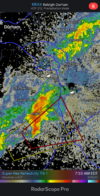
Member
Went back through the radar history and I’m pretty sure this is the tornado.Tornado possibly touched down 6 mile’s from me in pickens county. Possible house destroyed
Sent from my iPhone using Tapatalk

Jessy89
Member
Went back through the radar history and I’m pretty sure this is the tornado.View attachment 116190
Yep that’s it
Sent from my iPhone using Tapatalk
SWVAwxfan
Member
Things going crazy in Western NC And SW VA. Hearing reports of a damaging tornado that hit Carroll County VA tonight. Multiple warnings in NC.
If the Gfs is right we will have plenty of opportunities in the future to get it right.. delicate set ups to get the perfect storm dayIt's getting about as hard to get severe storms here as it is to get snow. 80% of the time we get plenty of kinematics but no instability.
My exact statement when I woke up. Let's see what she brings. Couplet looks weaker, but was also getting close to site. I do not believe there is much there, just a bit over threshold for a warning tbh.Good morning what the hell

I was right in the middle of that. There wasn't even a wisp of wind.