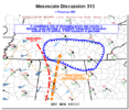
conditional risk / 40% watch probability into southern Tennessee.

Mesoscale Discussion 0313
NWS Storm Prediction Center Norman OK
0455 PM CDT Tue Mar 22 2022
Areas affected...portions of Southern-Middle Tennessee...extreme
northeast Alabama...extreme northwest Georgia
Concerning...Severe potential...Watch possible
Valid 222155Z - 222330Z
Probability of Watch Issuance...40 percent
SUMMARY...A conditional severe threat may develop with the
approaching squall line across southern-Middle Tennessee if adequate
moisture can arrive on time. A couple of damaging gusts would be the
main threat, though a tornado cannot be ruled out. A WW issuance is
possible.
DISCUSSION...A mature QLCS with a history of damaging gusts and
tornadoes is approaching portions of southern-Middle Tennessee.
Ahead of the QLCS, temperatures are in the mid-70s F surface
dewpoints, with dewpoints approaching 57 F. At the moment, buoyancy
is scant ahead of the squall, and RAP forecast soundings suggest
that dewpoints need to reach or exceed 59 F before convection can
become sufficiently rooted in the surface-layer to ingest the
abundant low-level streamwise vorticity to otherwise support a more
appreciable severe threat. Latest surface observations have shown up
to 59 F surface dewpoints across Lauderdale County, AL. As such, it
is possible that enough surface-based buoyancy may advect ahead of
the line into far southern-Middle TN to support the potential for a
few damaging gusts and perhaps a tornado. Either way, conditions
will continue to be monitored increasing buoyancy into TN and the
need for a possible WW issuance.

. Yeah that ain't going to touchdown. May get some hail and gusty winds. But 250 sbcape ain't going to cut it


