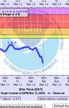
• Hello, please take a minute to check out our awesome content, contributed by the wonderful members of our community. We hope you'll add your own thoughts and opinions by making a free account!

Severe 3/11-12 Severe Weather

Pretty energetic system but timing is on our side if we want to see lessened severe chances. If it was coming through mid afternoon we would have some bigger issues. I am surpsied looking at temps at how quickly we recover and get into the upper 60s tomorrow morning. Huge temp gradient between here and Raleigh tomorrow as the front crosses.
Yeah if this was moving in from like 3-7 pm instead of like 7 am to noon we would be in deep ---- imo, we are really catching a break there
 
Yeah if this was moving in from like 3-7 pm instead of like 7 am to noon we would be in deep ---- imo, we are really catching a break there
Yeah but with the slp moving right over head and the wind dynamics still can't rule out a rogue Tor I guess, really are catching a break otherwise. UH not that strong but seem to be right along the lp track, should be a fun run in the morning lol

uh25_max.us_ma.png
 
Just curious, how many times, if at all, has there ever been a tornado and then snowfall at the same location on the same day around here? I'd say there is obviously a very slim chance but non-zero chance none the less
 
Just curious, how many times, if at all, has there ever been a tornado and then snowfall at the same location on the same day around here? I'd say there is obviously a very slim chance but non-zero chance none the less
In the true SE not hardly ever.. I do remember in mid 70's there was an instance that in Oklahoma they had tornadoes ina "minor" outbreak that occurred with convection that formed behind a cold front with snow on ground..
 
Just curious, how many times, if at all, has there ever been a tornado and then snowfall at the same location on the same day around here? I'd say there is obviously a very slim chance but non-zero chance none the less
Maybe after the March 84 tors?
 
Yeah but with the slp moving right over head and the wind dynamics still can't rule out a rogue Tor I guess, really are catching a break otherwise. UH not that strong but seem to be right along the lp track, should be a fun run in the morning lol

uh25_max.us_ma.png

Yeah there could be some curley Q type tornados on bowing segments, but if this squall line gets even a little bit organized its gonna have a screaming LLJ to tap into....70-80 mph winds will be 1500 ft up....even the ambient wind field is gonna crank 30-40 mph gust out and maybe even 40-50 mph gust for several hrs before the squall/front even hits. Probably be hopping between 6-10 tomorrow morning.
 
Yeah but with the slp moving right over head and the wind dynamics still can't rule out a rogue Tor I guess, really are catching a break otherwise. UH not that strong but seem to be right along the lp track, should be a fun run in the morning lol

uh25_max.us_ma.png
Lol you are crazy to run in the am. I think we are also getting aided by the overall forcing here and that should help things go fairly linear here instead of being more cellular so the bigger tor threat is from qlcs spin ups vs true supercells
 
Maybe after the March 84 tors?
Interesting, I'm not sure but just look at that event and Raleigh had a minimum pressure of 977mb, Norfolk 972, man what an insane dynamic system. So was there some snow on the backside? I can't remember and can't seem to find it, all attention on the tornado outbreak, which it should be.
 
Interesting, I'm not sure but just look at that event and Raleigh had a minimum pressure of 977mb, Norfolk 972, man what an insane dynamic system. So was there some snow on the backside? I can't remember and can't seem to find it, all attention on the tornado outbreak, which it should be.
As bad as 3-28-1984 was it could have been much worse. The storms stayed in about a 20-25 mile wide corridor with areas on either side of it not being hit as hard. Just one or two more long tracked storms would have made a big difference. Also if my memory is correct the storms missed all of the major metro areas. An outbreak like that today tracking along the I-85 corridor would be the worst case scenario for the Carolinas.

By the way here is a great sight that has data back to 1983 from the NWS on it
 
Lol you are crazy to run in the am. I think we are also getting aided by the overall forcing here and that should help things go fairly linear here instead of being more cellular so the bigger tor threat is from qlcs spin ups vs true supercells
Yeah any signals that the line may break up.would be a concern but fortunately no models really showing that.

The only time I remember a warm morning with snow that night was the 93' superstore but I don't think we had tornado warnings here
 
On a nerdy note the strong northwest winds should really blow the water out of the Pamlico and watching the tide gauges should really show a good strong wind tide effect
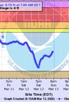
 
Just curious, how many times, if at all, has there ever been a tornado and then snowfall at the same location on the same day around here? I'd say there is obviously a very slim chance but non-zero chance none the less
I've got to smoke 4 butts tomorrow, have chopped by 4;30 lol. Can't get out of. Gonna be so much fun in the wind
 
Coastal plains of NC and SC in the enhanced zone now. Gonna have a wind chill of 9 degrees forecasted on Sunday morning. Gonna be a pretty epic temp swing
Yeah I just saw that and was coming in here to post, significant shift north with that

FNlh9LpUUAoPZNq
 
Mhx for the overnight into early mor ing before the main squall.

SW flow rapidly surges,
resulting in a screaming LLJ and 0-6km bulk shear clocking in 50-80+
kts. Along with weak, but increasing instability, any tstorms that
develop with this secondary warm front bears watching given the very
strong shear in the area. Because of this, SPC has placed our
FA in a Marginal Risk for severe weather overnight tonight.
 
Officially calling for a period of snow flurries/showers now after the morning severe weather.
 

Attachments

  • Screenshot_20220311-170930_Samsung Internet.jpg
    Screenshot_20220311-170930_Samsung Internet.jpg
    269.3 KB · Views: 12
Back
Top