Yeah if this was moving in from like 3-7 pm instead of like 7 am to noon we would be in deep ---- imo, we are really catching a break therePretty energetic system but timing is on our side if we want to see lessened severe chances. If it was coming through mid afternoon we would have some bigger issues. I am surpsied looking at temps at how quickly we recover and get into the upper 60s tomorrow morning. Huge temp gradient between here and Raleigh tomorrow as the front crosses.
-
Hello, please take a minute to check out our awesome content, contributed by the wonderful members of our community. We hope you'll add your own thoughts and opinions by making a free account!
You are using an out of date browser. It may not display this or other websites correctly.
You should upgrade or use an alternative browser.
You should upgrade or use an alternative browser.
Severe 3/11-12 Severe Weather
- Thread starter SD
- Start date
Yeah but with the slp moving right over head and the wind dynamics still can't rule out a rogue Tor I guess, really are catching a break otherwise. UH not that strong but seem to be right along the lp track, should be a fun run in the morning lolYeah if this was moving in from like 3-7 pm instead of like 7 am to noon we would be in deep ---- imo, we are really catching a break there

Just curious, how many times, if at all, has there ever been a tornado and then snowfall at the same location on the same day around here? I'd say there is obviously a very slim chance but non-zero chance none the less
gawxnative
Member
In the true SE not hardly ever.. I do remember in mid 70's there was an instance that in Oklahoma they had tornadoes ina "minor" outbreak that occurred with convection that formed behind a cold front with snow on ground..Just curious, how many times, if at all, has there ever been a tornado and then snowfall at the same location on the same day around here? I'd say there is obviously a very slim chance but non-zero chance none the less
Maybe after the March 84 tors?Just curious, how many times, if at all, has there ever been a tornado and then snowfall at the same location on the same day around here? I'd say there is obviously a very slim chance but non-zero chance none the less
Downeastnc
Member
Yeah but with the slp moving right over head and the wind dynamics still can't rule out a rogue Tor I guess, really are catching a break otherwise. UH not that strong but seem to be right along the lp track, should be a fun run in the morning lol
Yeah there could be some curley Q type tornados on bowing segments, but if this squall line gets even a little bit organized its gonna have a screaming LLJ to tap into....70-80 mph winds will be 1500 ft up....even the ambient wind field is gonna crank 30-40 mph gust out and maybe even 40-50 mph gust for several hrs before the squall/front even hits. Probably be hopping between 6-10 tomorrow morning.
Lol you are crazy to run in the am. I think we are also getting aided by the overall forcing here and that should help things go fairly linear here instead of being more cellular so the bigger tor threat is from qlcs spin ups vs true supercellsYeah but with the slp moving right over head and the wind dynamics still can't rule out a rogue Tor I guess, really are catching a break otherwise. UH not that strong but seem to be right along the lp track, should be a fun run in the morning lol
Interesting, I'm not sure but just look at that event and Raleigh had a minimum pressure of 977mb, Norfolk 972, man what an insane dynamic system. So was there some snow on the backside? I can't remember and can't seem to find it, all attention on the tornado outbreak, which it should be.Maybe after the March 84 tors?
JHS
Member
As bad as 3-28-1984 was it could have been much worse. The storms stayed in about a 20-25 mile wide corridor with areas on either side of it not being hit as hard. Just one or two more long tracked storms would have made a big difference. Also if my memory is correct the storms missed all of the major metro areas. An outbreak like that today tracking along the I-85 corridor would be the worst case scenario for the Carolinas.Interesting, I'm not sure but just look at that event and Raleigh had a minimum pressure of 977mb, Norfolk 972, man what an insane dynamic system. So was there some snow on the backside? I can't remember and can't seem to find it, all attention on the tornado outbreak, which it should be.
By the way here is a great sight that has data back to 1983 from the NWS on it
Iowa Environmental Mesonet
Iowa Environmental Mesonet of Iowa State University
Shaggy
Member
Yeah any signals that the line may break up.would be a concern but fortunately no models really showing that.Lol you are crazy to run in the am. I think we are also getting aided by the overall forcing here and that should help things go fairly linear here instead of being more cellular so the bigger tor threat is from qlcs spin ups vs true supercells
The only time I remember a warm morning with snow that night was the 93' superstore but I don't think we had tornado warnings here
Shaggy
Member
On a nerdy note the strong northwest winds should really blow the water out of the Pamlico and watching the tide gauges should really show a good strong wind tide effect
I've got to smoke 4 butts tomorrow, have chopped by 4;30 lol. Can't get out of. Gonna be so much fun in the windJust curious, how many times, if at all, has there ever been a tornado and then snowfall at the same location on the same day around here? I'd say there is obviously a very slim chance but non-zero chance none the less
Shaggy
Member
Nam3k is a nasty squall line for eastern NC.
pcbjr
Member


Shaggy
Member
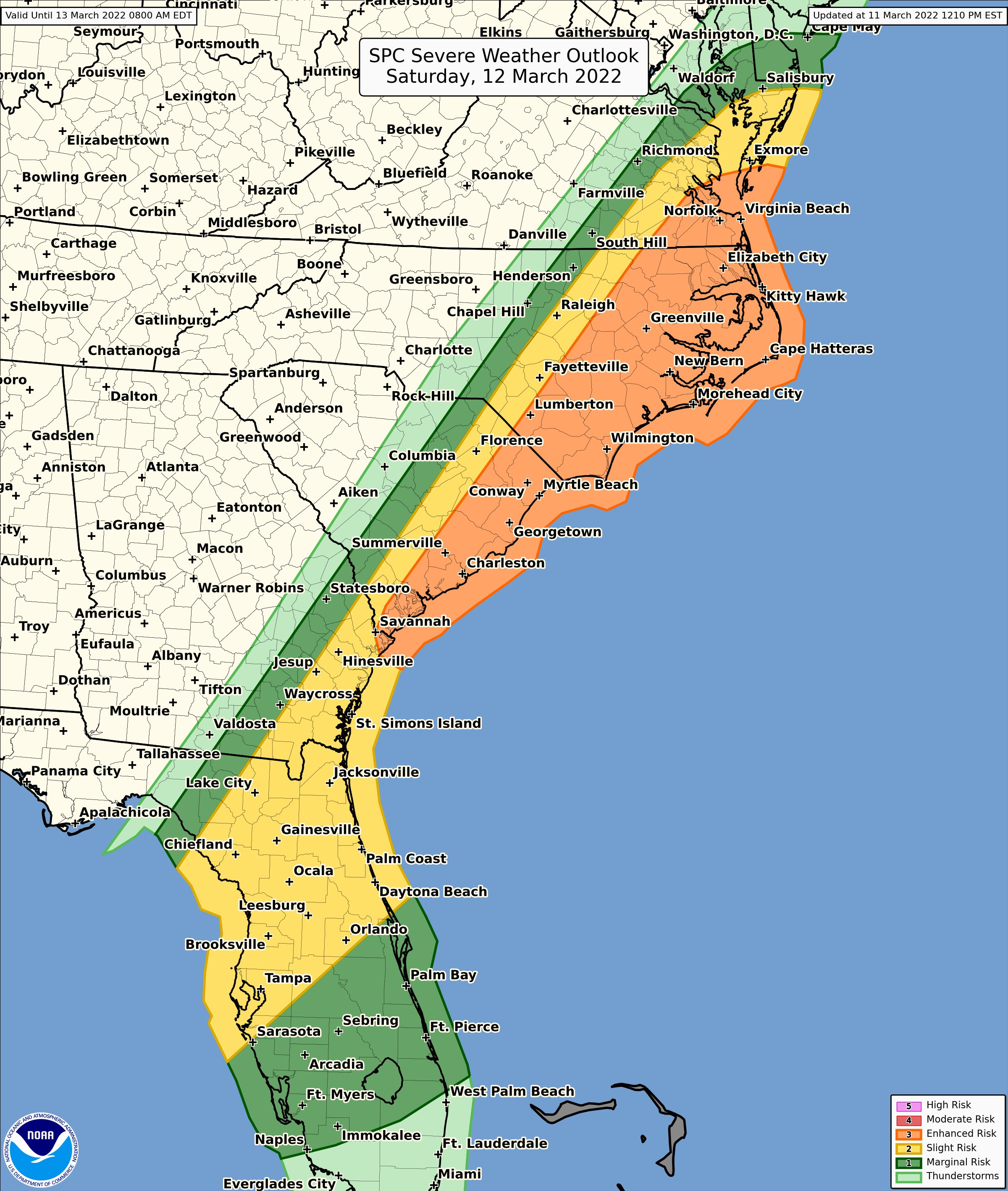
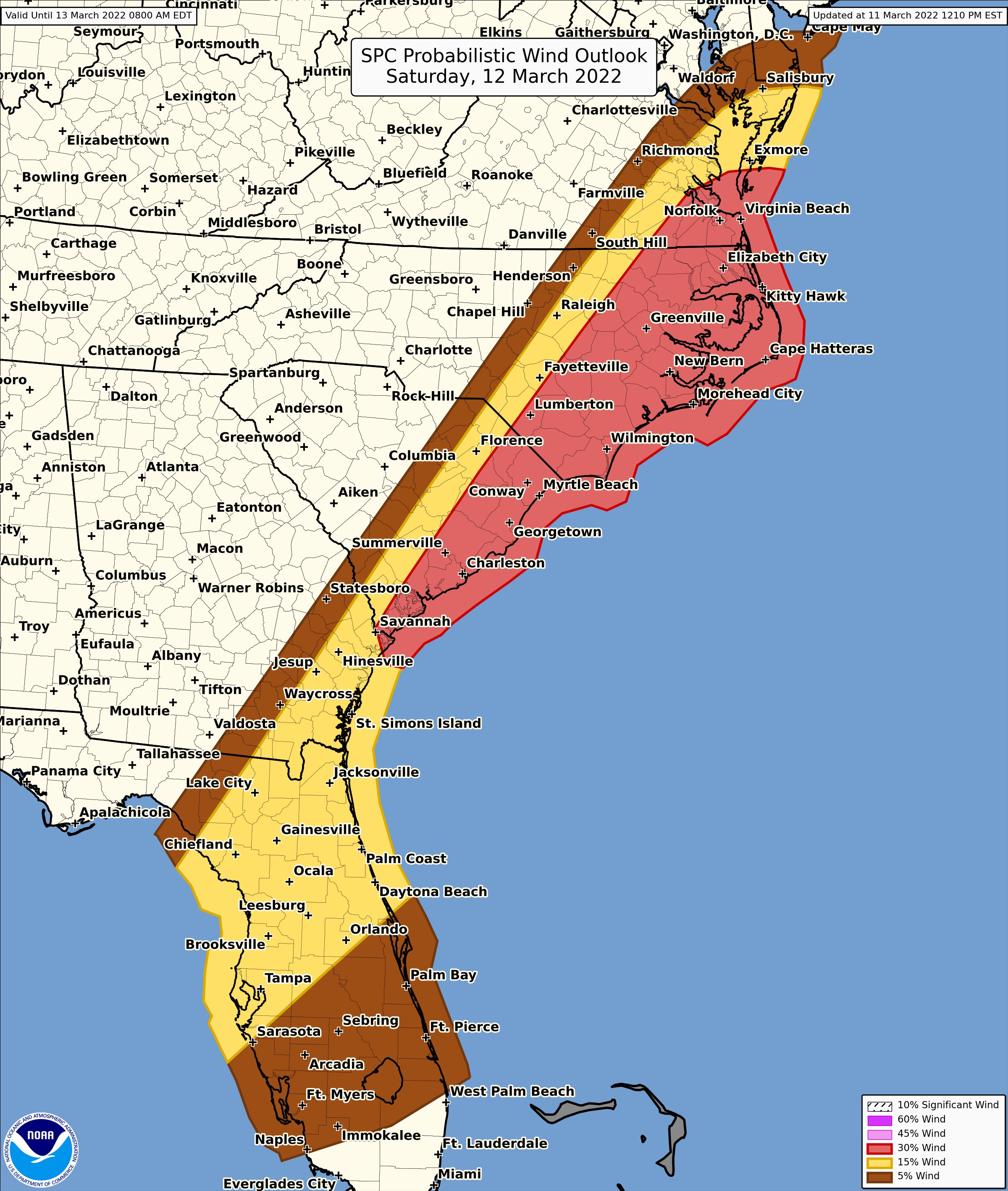
Coastal plains of NC and SC in the enhanced zone now. Gonna have a wind chill of 9 degrees forecasted on Sunday morning. Gonna be a pretty epic temp swing
NBAcentel
Member
Hrrr going crazy with that elevated Convection wonder if winds could be dragged down
Yeah I just saw that and was coming in here to post, significant shift north with thatCoastal plains of NC and SC in the enhanced zone now. Gonna have a wind chill of 9 degrees forecasted on Sunday morning. Gonna be a pretty epic temp swing

Shaggy
Member
Mhx for the overnight into early mor ing before the main squall.
SW flow rapidly surges,
resulting in a screaming LLJ and 0-6km bulk shear clocking in 50-80+
kts. Along with weak, but increasing instability, any tstorms that
develop with this secondary warm front bears watching given the very
strong shear in the area. Because of this, SPC has placed our
FA in a Marginal Risk for severe weather overnight tonight.
Shaggy
Member
Downeastnc
Member
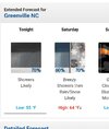
Awesome local forecast for tomorrow, has all my favorite words in it...
Saturday
Rain showers before 3pm, then a chance of rain and snow showers. Some thunder is also possible. Temperature rising to near 65 by 8am, then falling to around 36 during the remainder of the day. Breezy, with a south wind 16 to 23 mph becoming northwest in the afternoon. Winds could gust as high as 40 mph. Chance of precipitation is 80%. Little or no snow accumulation expected.
Darklordsuperstorm
Member
Supercells forming in the GOM

HSVweather
Member
Z
Zander98al
Guest
Z
Zander98al
Guest
Probably going to be active night in south Alabama tonight.
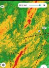
HRRR pretty stout around 7 in the morning

Downeastnc
Member
HRRR pretty stout around 7 in the morning
View attachment 115460
Seems likely that would tapping into that LLJ rather efficiently, gonna be a solid 40-50 mph wind along that I bet, probably last a good couple of minutes.
3k NAM is pretty outrageous with it's gusts in the morning. Pretty cool though how you can see the front and the stronger gusts south of the warm front in eastern NC
Downeastnc
Member
3k NAM is pretty outrageous with it's gusts in the morning. Pretty cool though how you can see the front and the stronger gusts south of the warm front in eastern NCView attachment 115471
The next two frames of the NAM moves that area of 50+ gust near Marion over central and eastern NC....probably be good enough for some scattered power outages, if this was a few weeks later and the trees were all leafed out it would be worse.
Downeastnc
Member
Latest 3k NAM run brings the business....its overdone but some 50 mph gust seem doable over a good chunk of NC...


Downeastnc
Member
LLJ stout

Stormsfury
Member
Latest 3k NAM run brings the business....its overdone but some 50 mph gust seem doable over a good chunk of NC...
View attachment 115502
View attachment 115503
Ground truth this morning in the Charleston Area bears this out as verified. Winds have been over 50mph at times and multiple trucks have been overturned in West Ashley on the Wando/Don Holt bridges this morning forcing closures of the two.
Pressure down to 29.16” HG
Z
Zander98al
Guest
3 decent rotations in Florida. One tornado warned.
994.3 minimum pressure and max wind gust of 19.5


Shaggy
Member
Yep, missed it by that much

Bottomed out at 992.5mb ~9am, 0.74” event total, wind gauge is sheltered but still managed to clock 26.8mph, guess is gusts were close to 40.