Not as exciting a storm as I expected at my house. Peak rain rate about 2"/hr, just over 0.5" total. Highest guts at my house about 26 mph (keep in mind, the anemometer is only at 4 m).
-
Hello, please take a minute to check out our awesome content, contributed by the wonderful members of our community. We hope you'll add your own thoughts and opinions by making a free account!
You are using an out of date browser. It may not display this or other websites correctly.
You should upgrade or use an alternative browser.
You should upgrade or use an alternative browser.
Severe 3/1-4 SEVERE WEATHER
- Thread starter SD
- Start date
Sunny, balmy with dp 63 and temp 72 in Athens GA right now.
Tor watch comin east
565
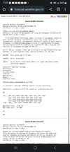
ACUS11 KWNS 031912
SWOMCD
SPC MCD 031912
TNZ000-NCZ000-SCZ000-GAZ000-032045-
Mesoscale Discussion 0247
NWS Storm Prediction Center Norman OK
0112 PM CST Fri Mar 03 2023
Areas affected...Eastern Tennessee into parts of northern Georgia
Concerning...Severe potential...Tornado Watch likely
Valid 031912Z - 032045Z
Probability of Watch Issuance...80 percent
SUMMARY...An additional watch will likely be needed for parts of
eastern Tennessee and northern Georgia. Despite weaker
thermodynamics, strong, veering low-level winds will support a risk
for damaging winds and brief tornadoes.
DISCUSSION...A fast moving line of storms will continue eastward
through Middle Tennessee and northern Alabama. Strong wind fields
continue to be sampled by regional VAD data. Some cloud cover has
kept temperatures a bit subdued, particularly in north Georgia.
Parts of eastern Tennessee have warmed into the mid 70s F. Between
cooler temperatures, decreased moisture, and warmer temperatures
aloft (especially with southward extent), the overall thermodynamic
environment will likely be weaker than areas to the west. However,
storm motion in addition to 50-70 kts within the boundary layer
would support a threat for damaging winds even with relatively weak
updrafts. Strong low-level shear would also promote some risk for
brief tornadoes within the line of storms. A watch for parts of this
region will likely be needed this afternoon.
..Wendt/Grams.. 03/03/2023
- Joined
- Jan 5, 2017
- Messages
- 3,769
- Reaction score
- 5,966
That couplet in NW GA is about to cross I-75...
The wind behind the storms ain't no joke, either!
I was watching it come in on my Ring camera that faces west. It is under a 10' overhang and well off the ground but just got knocked offline in the squall.
Same in McCalla AL. Had some of the biggest gusts of the day in the past hour.The wind behind the storms ain't no joke, either!
No wedge to save us today..incoming?
rburrel2
Member
njbarrineau
Member
Looks like the cells in the upstate are trying to strengthen closer to the GA border
Sent from my iPhone using Tapatalk
Sent from my iPhone using Tapatalk
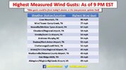
Rome, GA had a gust up to 54. Pretty impressive.
Tuscaloosa had a 71.6 mph gust when the QLCS blew through.
- Joined
- Jan 5, 2017
- Messages
- 3,769
- Reaction score
- 5,966
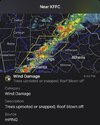
Is that a tornado near Holly Springs, GA?
Cbmatt2408
Member
The cell just outside of Carrollton, GA is becoming semi-discrete with a little rotation on the south end. Might be worth watching.
WXinCanton
Member
That cell has a warning on it nowIs that a tornado near Holly Springs, GA?
Last edited:
I hate the angle of this line. It’s taking its sweet time..
ForsythSnow
Moderator
That's very very close to my area but we didnt get it that bad
shortstopsergio
Member
Just pushed through midtown Atlanta. Not very impressive in my opinion… two claps of thunder… lasted like 5 minutes.. breezy with some heavy rain but overall very disappointing here
HugeSnowStick
Member
Yes, this was much ado about nothing...Morningside here,,,Just pushed through midtown Atlanta. Not very impressive in my opinion… two claps of thunder… lasted like 5 minutes.. breezy with some heavy rain but overall very disappointing here
Anybody talking about the fact that it's in the upper 40s in Northern Iredell and in the low 70s in Southern Iredell County?? Is that CAD? It's astonishing the difference in just a very short drive today
The big question was “will there be storms to take advantage of the extreme parameters?”. Yes, there were storms. Deep storms with strong updrafts, yet we lacked tornadogenesis. Mesocyclogenesis occurred but tornadogenesis didn’t. Not exactly sure why, maybe downdrafts were too cold due to the dry nature of the atmosphere.
Phil Connors
Member
The big question was “will there be storms to take advantage of the extreme parameters?”. Yes, there were storms. Deep storms with strong updrafts, yet we lacked tornadogenesis. Mesocyclogenesis occurred but tornadogenesis didn’t. Not exactly sure why, maybe downdrafts were too cold due to the dry nature of the atmosphere.
A deep layer of warm air aloft created a cap that was dominant
Sent from my iPhone using Tapatalk
SWVAwxfan
Member
Tornado warning just formed about 5 miles to my southeast
??
??
SWVAwxfan
Member
Saw a report that a tornado touched down near Gray Court SC.
SWVAwxfan
Member
Looks like that line could hit Columbia a bit later.
JHS
Member
Had a gust probably around 50-60 mph here with the line. The line strengthened once it got into the upstate, but looks to be weakening now, probably for good. Not sure about a tornado touchdown near Gray Court, but that storm was huge and had a lot of lightning in it. There are damage reports in Laurens county from it, but they seem to be from straight line winds.
Very thankful for the warm nose, because without it today would have been rough. Storms tried to form ahead of the line, but that mid level warm air kept them in check.
Very thankful for the warm nose, because without it today would have been rough. Storms tried to form ahead of the line, but that mid level warm air kept them in check.
WFFaithful
Member
Temps rose roughly 15 degrees here in under an hour. Very strange.Anybody talking about the fact that it's in the upper 40s in Northern Iredell and in the low 70s in Southern Iredell County?? Is that CAD? It's astonishing the difference in just a very short drive today
campamy
Member
SWVAwxfan
Member
79 degrees at KCAE with winds gusting to 41. Crazy warm for this late in the evening. Line is approaching from west.
RDU with wind gust to 41 but not in the wind advisory, seems about right
Posted this on Twitter but will copy over to here if anyone wants to chime in
I think some post-storm analysis is in order for this system, specifically looking at the lack of many tornadoes today. In Georgia/Alabama specifically, the question all week was “will deep convection form?”… and the answer to that was yes. Very deep convection formed across the warm sector and manifested as a strong QLCS, yet, *thankfully*, there weren’t many tornadoes.
This QLCS was ingesting inflow with high CAPE (>1500-2000 SBCAPE) and intense streamwise vorticity (ESRH >900!!).. overall an extremely environment (STP 9+).. we saw the line kink and saw mesocyclogenesis occur; there were several embedded supercells within the QLCS especially around 20-22z in west Georgia into Tennessee. These storms had *intense* inflows and appeared to be structurally sound; in fact, I witnessed 3 or 4 fully developed rotating wall clouds today and saw several weak & broad rotations on radar in these storms.
The one thing we didn’t see, which I would expect from a broken supercellular QLCS ingesting 9+ STP, was widespread tornadoes. It’s a great thing that we avoided having many tornadoes because these storms moved very quickly across densely populated areas. It is still curious, however, as to why we had such robust mesocyclogenesis with limited tornadogenesis.
I don’t think that the warm nose around 600mb was to blame for this. We still had robust deep convection form despite that warm nose. Perhaps that warm nose prevented discreet supercell formation ahead of the line, but it doesn’t explain the QLCS’ features itself. Only explanation I can really think of is the dryness of the atmosphere leading to downdrafts that were just too cold & stable to sustain tornadogenesis. I’m guessing we had many instances of failed tornadogenesis as a result of this. Studies have shown that QLCS tornado risk increases as PWAT increases, and these factors may be related. There are some notable exceptions, however.. Jan 12 of this year featured relatively low pwats and yet produced several sig tors.
Thoughts on this? We had mesocyclogenesis happen along the QLCS. We had decent separation at times between individual updraft regions. We had kinks, inflow notches, reflectivity drops.. only lacked, in general, successful tornadogenesis.
JHS
Member
NWSChat - NOAA's National Weather Service
An EF-1 tornado moved through parts of Laurens and Spartanburg counties.
Darklordsuperstorm
Member
Jam packed detailed video on what to possibly expect this spring. I have said it before but this guy knows his stuff!


